India
![]()
This article is about the country - for other meanings see India (disambiguation).
Template:Infobox State/Maintenance/TRANSCRIPTION
Template:Infobox State/Maintenance/NAME-German
India (pronunciation [ˈɪndi̯ən]) is a country in South Asia, comprising most of the Indian subcontinent. India is a federal republic formed by 28 states and also includes eight federally-unified territories. The proper name of the republic is Bharat Ganarajya (Hindi) and Republic of India (English) in the two official languages used throughout the country. The modern democratic and secular Indian Republic has been in existence since 1949, and the Constitution of India has been in force since 1950.
The Himalayas form the natural northern border of India, in the south the Indian Ocean encloses the national territory. India borders Pakistan, the Chinese Autonomous Region of Tibet, Nepal, Bhutan, Myanmar and Bangladesh. Other neighbouring countries in the Indian Ocean are Sri Lanka and the Maldives. In terms of land area, India is the seventh largest country in the world.
The territory of India has been civilized since at least the Bronze Age Indus civilization. With a population of over 1.393 billion (May 2020), the Indian state is the second most populous country on earth after the People's Republic of China (1.4 billion at the end of 2018), making it the most populous democracy in the world. If population growth remains high, India could overtake China as early as 2022. However, due to ongoing modernization, education, prosperity and urbanization, the birth rate has been falling since the early 1980s. India's capital is New Delhi, part of the Delhi metropolitan area; other metropolitan areas are Mumbai, Kolkata, Chennai, Bengaluru, Hyderabad, Ahmedabad and Pune.
Despite constitutional freedom of religion, Indian society is determined by the religious hierarchical caste system. Hindus are by far the largest religious group, followed by Muslims, Christians, and the Sikhs, Buddhists, and Jaina, who historically originated in India. According to the Human Development Index (HDI), India achieves "medium human development" status and was ranked 129 out of 189 in the world in 2019 (compared to PRC at 85). Economically, India is considered an emerging economy and belongs to the O5 and BRICS countries and the Group of Twenty major industrialized and emerging economies (G20). Despite its still low per capita income, India is already the world's third-largest and fifth-largest economic power (adjusted for purchasing power and in nominal terms, respectively) and was the fastest-growing economy in the G20 group for the first time in 2015.
Origin of the name
The name India is derived from the river Indus. Its name in turn goes back to the Sanskrit word sindhu meaning "river" through the mediation of ancient Greek (Indos) and ancient Persian (Hinduš). The European seafarers referred to the whole of South and Southeast Asia as India. Terms such as island India ("Insulinde") and the state name Indonesia still bear witness to this. The term East Indies was also used to distinguish it from the islands of the Caribbean known as the West Indies, which Christopher Columbus discovered in his search for a sea route to India. During the colonial period, the name was gradually reduced to the present-day territories of India, Pakistan and Bangladesh, and finally assumed its present meaning when the Indian state was founded.
The name Hindu and the name of the language Hindi are also derived from the Persian form Hind or Hindustan. The official name of India in most national languages (e.g. Hindi Bhārat) derives from the Sanskrit term Bhārata, which means "(land) of Bharata" and refers to a mythical ruler.
Geography and nature of the country
Landscape structure
With 3,287,490 square kilometres, India is the seventh largest country on earth. It extends in west-east direction from the 68th to the 97th eastern degree of longitude over about 3000 kilometers. From north to south, between the 8th and the 37th degree of northern latitude, the extension is about 3200 kilometres. India borders six countries: Pakistan (2912 kilometres), China (Tibet Autonomous Region; 3380 kilometres), Nepal (1690 kilometres), Bhutan (605 kilometres), Myanmar (1463 kilometres) and Bangladesh (4053 kilometres). Thus, the total border length is 14,103 kilometers. Since the northern part of disputed Kashmir has been under Pakistani control since 1949 (ceasefire after Kashmir conflict), India no longer shares a border with Afghanistan. The country's coastline is about 7000 kilometres long.
The natural border in the north and northeast is formed by the Himalayas, the highest mountains in the world, which are separated in the extreme northwest by the high valley of the Indus from the Karakoram and the Ladakh Range in front of it. To the south of the Himalayas are the broad, fertile flood plains of the Ganges and Brahmaputra rivers. To the west, the Ganges River floodplain merges into the Thar Desert, which is bounded by the Aravalli Mountains to the east and south. South of this lie the marshes of the Rann of Kachchh and the Kathiawar peninsula. The northeast of India, including the Brahmaputra Plain, is connected to the rest of the country only by a narrow corridor between Bangladesh and Nepal or Bhutan. The northeast region is shielded by the Patkai or Purvachal Mountains of Myanmar, which are up to 3800 meters high, and the Khasi Mountains of Bangladesh, which are nearly 2000 meters high.
The Deccan highlands occupy most of the Indian peninsula projecting in a wedge shape into the Indian Ocean. The Vindhya and Satpura Mountains shield the Deccan from the Ganges plain to the north. To the west it is bounded by the Western Ghats, which rise to 2700 metres, and to the east by the flatter Eastern Ghats. Both mountain ranges meet in the south, where the peninsula tapers to Cape Comorin. The Western Ghats drop steeply to the Konkan and Malabar coasts along the Arabian Sea. The Eastern Ghats merge with the broader eastern coastal plains on the Bay of Bengal.
India also includes three island groups off the Indian subcontinent. Around 300 kilometres west of the Malabar coast lie the coral atolls of Lakshadweep, which includes the island groups of the Lakkadives and Amindives as well as the island of Minicoy. Southeast of the peninsula, between 1000 and 1600 kilometers from the Indian mainland, stretch the Andaman and Nicobar Islands, which also mark the eastern border of the Bay of Bengal.
The highest point in India is the mountain Kangchendzönga with 8586 meters height. It lies in the far west of Sikkim; the border with Nepal runs across it. The highest mountain lying entirely within Indian territory is Nanda Devi at 7822 metres. Before the then Kingdom of Sikkim joined the Indian Union in 1975, this was also the highest mountain in India. The lowest point is the Kuttanad Depression, two meters below sea level, on the Malabar Coast.
Rivers and lakes
All of India's major rivers originate in one of the subcontinent's three main watersheds: the Himalayas, the central Indian Vindhya and Satpura Mountains, or the Western Ghats.
India's longest and most important river is the Ganges (Ganga), which rises in the Himalayas. Its longest tributaries are the Yamuna and the Gomti; the Chambal is a tributary of the Yamuna. The Brahmaputra, whose upper course in its turn separates the Himalayas from the Trans-Himalayas, and which flows through the country to the north-east, unites with the Ganges, and forms a vast delta before its mouth in the Bay of Bengal. India has a share of this in the west; the majority of the Ganges delta lies on the territory of the neighbouring state of Bangladesh. Almost one third of India's surface area belongs to the catchment area of the Ganges and Brahmaputra.
In the far north, the Indus River crosses the Union Territory of Ladakh in a southeast-northwest direction.
The Deccan highlands are drained by several major rivers. The Narmada and the Tapti flow into the Arabian Sea, while the Godavari, Krishna, Mahanadi and Kaveri flow to the Bay of Bengal.
Despite its size, India has only a few large natural lakes. For irrigation and power generation, huge reservoirs have been built throughout the country. The largest are the Hirakud Reservoir (746 square kilometres) in Odisha, the Gandhi Reservoir (648 square kilometres) in Madhya Pradesh and the Govind Ballabh Pant Reservoir (465 square kilometres) on the border between Uttar Pradesh and Chhattisgarh.
Geology
The theory of continental drift states that India belonged to the southern continent of Gondwana until towards the end of the Jurassic. In the Cretaceous period it tore away from the continental shelf of Antarctica and drifted across the entire Tethys Ocean towards the south of the Eurasian Plate in an extremely short 50 million years in terms of geological history. The collision of the two parts of the Earth occurred at the beginning of the Paleogene, estimated to be about 43 to 64 million years ago. In the resulting common "crumple zone" of these crustal movements, the Himalayas and adjacent mountain systems were pushed up (unfolding of the former continental margins) and the highlands of Tibet were uplifted.
Although individual parts of the crust have since welded together, the Indian Plate is still moving northwards today, so that the Himalayas rise by a few millimetres every year - just like other fold mountains on earth, of which they are one of the youngest. The river plains in front of it were formed by sediment deposits in the Pleistocene. More diverse are the rock formations of the Deccan. Proterozoic formations in the south and east, the Cretaceous volcanic Deccan trap in the west and northwest, and unformed cratons in the northeast and north, which are among the oldest parts of the Earth's crust, occupy the majority.
Natural disasters
India is repeatedly hit by various natural disasters, especially floods, which can occur during the summer monsoon due to extreme rainfall throughout the country. On the other hand, droughts are common during the dry season or in the absence of monsoon rains. Cyclones and the resulting tidal waves, especially on the east coast, also often cost many lives and cause devastating damage. There is also an increased risk of earthquakes in some areas, namely in the Himalayas, the north-eastern states, western Gujarat and the region around Mumbai. On 26 December 2004, a seaquake in the Indian Ocean caused a devastating tsunami that claimed 7793 lives and wreaked havoc on the east coast and in the Andaman and Nicobar Islands.
Climate
With the exception of the mountainous regions, the climate in northern and central India is mainly subtropical continental, while in the south and coastal areas the climate is more maritime and tropical. In the north, for example, there are sometimes considerable temperature fluctuations in the course of the year. In the northern lowlands, temperatures range from 10 to 15 °C in December and January; in the hottest period between April and June, maximum temperatures of 40 to over 50 °C are possible. In the south, on the other hand, it is hot (relatively constant) all year round.
Rainfall throughout the country is significantly influenced by the Indian monsoon. The southwest or summer monsoon begins in most parts of the country in June and, depending on the region, brings abundant rainfall until September or October. Due to the very different topography, the rainfall distribution is highly uneven. The heaviest rainfall occurs on the west coast, in the Western Ghats, on the slopes of the Himalayas and in north-eastern India. It is driest in the Thar. The northeast or winter monsoon winds coming from Central Asia between October and June bring little moisture, so in most areas 80 to over 90% of the total annual precipitation falls during the summer months. Only the southeast receives rain even during the northeast monsoon, as air currents over the Bay of Bengal pick up moisture.
Vegetation
Due to the size of the country and the different climatic conditions in the various parts of the country, India has a wide variety of landscapes. The flora of India ranges from high mountain vegetation in the Himalayas to tropical rainforests in the south. Large parts of the original vegetation cover have been destroyed today; instead, India is predominantly characterised by cultivated landscapes. Only about one fifth of the country is still forested, although official figures vary and include degraded areas and open forests. In 2015, a forest area of 701,700 km² was reported: 21.3% of the country's land area (3,287,300 km²). In 2001, the figures were still 768,400 km² and 23.4 % - in 14 years, India's forest area shrank by 9.5 %.
In the lower altitudes of the Himalayas, extensive forests still extend. As precipitation on the slopes of the mountains decreases from east to west, evergreen subtropical and temperate moist and rain forests are found in the eastern Himalayas, becoming thinner and drier towards the west. Deciduous forests of oak and chestnut predominate; rhododendrons are characteristic of the Eastern Himalaya. At higher altitudes conifers, especially cedars and pines, dominate. The steppe- and desert-like high valleys of Ladakh and other parts of the western Inner Himalaya merge into the dry highlands of Tibet. The vegetation limit is at about 5000 meters.
The northeast, which is difficult to access, is still densely forested in parts. Particularly high precipitation amounts allow semi-evergreen wet forests there.
By far the largest part of the Ganges plain, the Deccan and the adjacent marginal mountains used to be covered by monsoon forests; today there are only remnants of them, mostly in mountainous regions. The intensively farmed plains, on the other hand, are virtually forest-free. Monsoon forests shed leaves during dry periods. Depending on the amount of rainfall and the length of the dry period, a distinction is made between wet and dry forests. Forests that receive between 1500 and 2000 millimeters of annual precipitation are usually called deciduous moist forests. They prevail in the northeastern Deccan, Odisha and West Bengal and in the lee of the Western Ghats. When rainfall is between 1000 and 1500 millimetres per year, they are called deciduous dry forests; these dominate in India. Because of the thinner tree crowns, monsoon forests have a dense undergrowth. The characteristic tree species of the north is the sal (Shorea robusta), in the central and western Deccan highlands it is the teak tree (Tectona grandis) and the south of the peninsula is characterized by sandalwood trees (Santalum album). Bamboo species are widespread.
In the drier parts of India, such as Rajasthan, Gujarat, the western edge of the Ganga lowlands or the central Deccan, grow the endemic rivet trees, which are used especially for medicinal purposes. In the arid climate, open thorn forests have developed, which in the Thar desert change into semi-desert vegetation with isolated thorn bushes.
In the humid Western Ghats, there are still relatively large contiguous tracts of the original evergreen or semi-evergreen moist forests. They are characterized by the canopy structure typical of tropical rainforests. Some of the tall tree species of the uppermost storey shed their leaves seasonally, while species growing below them are evergreen. Perching plants such as orchids and ferns occur in great diversity.
Mangroves, saltwater-resistant tidal forests, are common only on the east coast of India. The Sundarbans in the Ganges-Brahmaputra delta have the densest mangrove stands in the country. Other tidal forests are found in the Mahanadi, Godavari and Krishna estuarine deltas.
Wildlife
Thanks to its landscape diversity, India is home to an extremely diverse fauna. It is estimated that about 350 species of mammals, 1200 species of birds, 400 species of reptiles and 200 species of amphibians are native to the country. However, many species are found only in refuges such as forests, swamps, mountainous and hilly areas. Indian waters are also home to more than 2500 species of fish.
India's largest mammal species is the Indian elephant, which is probably also the best known along with the Royal Bengal Tiger. The tiger was threatened with extinction for a long time, but through the establishment of tiger sanctuaries, the populations could recover. Nevertheless, there are only a few thousand specimens in the wild. Besides the tiger, other big cats live in India, including leopards and lions. The latter are found exclusively in the Gir National Park in Gujarat, the last refuge of the Asiatic lion. The rare snow leopard inhabits the high mountainous regions of the Himalayas. The best known and most widespread of the smaller predator species is the mongoose.
The tank rhinoceros lives only in swamp and jungle areas in Assam, especially in the Kaziranga National Park.
In contrast, cloven-hoofed animals are widespread. These include wild boar, muntjacs, sambars, axi deer, hog deer, barasinghas, water buffalo, gaur and several species of antelope.
The horse-types are represented by the Kiang in the Himalaya and the Khur, a subtype of the Asian donkey, in the semi-desert of Gujarat.
Monkeys are also common in India. Rhesus monkeys are considered sacred by Hindus, may not be molested and have therefore spread even in cities. In the south of the country, the is replaced by the slightly smaller Indian cap monkey. The Hanuman langurs, which are widespread throughout India, are also considered sacred. In addition, there are other species of langurs as well as macaques.
The dry areas of the northwest are still home to a few Indian half-assed donkeys, most of which are found in the Dhrangadhra Game Reserve in the Little Rann of Kachchh. In the humid east of the country, on the other hand, live species of the tropical rainforest, such as white-browed gibbons and clouded leopards. Other mammals worth mentioning are the red dogs, striped hyenas, Bengal foxes, which inhabit mainly grasslands, and the sloth bears, which prefer dense forests. In the Ganges, Brahmaputra and their tributaries the Ganges dolphin is occasionally found.
India's bird life is extremely diverse with over 1200 native species - more than in the whole of Europe. In addition, there are countless migratory birds from North Asia in winter. The peacock is considered the national bird and is widespread. Pigeons, crows, weavers, woodpeckers, pittas, drongos, parakeets, nectar birds and orioles are also common. Wetlands are home to storks, herons, cranes, ibises, and kingfishers. Among birds of prey, Egyptian and Bengal vultures were most common. While the latter was ubiquitous in the 1980s, it, along with two closely related species, has been unintentionally almost wiped out by a veterinary drug.
About half of all reptile species native to India are snakes such as the spectacled snake, the king cobra and the tiger python. However, swamp crocodiles are also found in wetlands. Very rare is the shy, fish-eating Ganges gavial. A special feature is the occurrence of chameleons in southern India and Sri Lanka, which are otherwise absent in South Asia.
Nature and environmental protection
With a very high species diversity and biodiversity (especially in a narrow strip on the humid tropical southwest coast), a markedly large number of endemic species, genera and families of plants and animals, as well as diverse ecosystems, India is considered one of the world's megadiverse countries. In addition, the rainforests of the Western Ghats are listed as a biodiversity hotspot due to their high vulnerability.
India has extensive environmental protection legislation, but in many cases its implementation is poor. Just under 5% of the country's land area is designated as nature reserves, which number almost 600, including 92 national parks.
Water scarcity is one of India's biggest environmental problems. Dams and artificial irrigation systems are intended to secure the water supply in dry areas. Excessive irrigation is one of the main reasons for falling groundwater levels in many places; in addition, an estimated 60 % of agricultural land is affected by soil erosion, salinisation or waterlogging. In addition, deforestation, over-irrigation and fertilization occur. The water supply situation of many households in rural areas has improved since the early 1980s; nevertheless, few households have sanitation. Polluted and contaminated water is a major contributor to the emergence and spread of infectious diseases; only 16% of India's residents have access to sanitation. NGOs such as the Water Literacy Foundation and government agencies such as the Ministry of Drinking Water and Sanitation are working to improve the situation.
Air pollution is very high, especially in Indian metropolitan areas. Factories, small industries, power plants (including numerous coal-fired power plants), traffic and private households emit numerous air pollutants, including large amounts of particulate matter. According to a study by the World Health Organization, Delhi was the dirtiest city in the world in terms of air quality in 2014. Kolkata was the first city to launch a metro network in 1984, followed by Delhi in 2002. Mumbai and Chennai have comparatively well-developed train networks. Trucks, buses, over 5,000 diesel locomotives, autorickshaws, private cars, motorcycles and mopeds contribute to air pollution. The number of cars per 1000 inhabitants is considered very low. CO2 emission has increased sharply in the past; causes included population growth, ongoing industrialization and increasing traffic. In 2015, India was considered the third largest greenhouse gas emitting country in the world; it emitted 1.6 tons per capita. India signed the Paris Agreement on 2 October 2016.
The inadequate technical installations in factories often lead to adverse effects or avoidable emissions. In Bhopal in 1984, highly toxic gases leaked from the pesticide factory of the American Union Carbide (UCC) (Bhopal disaster). Within days, 7000 people died, 15,000 more died of late effects, thousands suffered chronic health damage.
Protected areas
India-wide, as of March 2019, there are a total of 868 Protected Areas (PAs) in Nature and Landscape Conservation, accounting for 5% of India's total geographical area of 3,287,000 sq km (including the Indian-administered parts of Kashmir) - an increase of 11,000 sq km or 0.35% since 2009:
| Protected areas | 2019 | 2009 | Area | 2009 | 0Share0 | 2009 |
| National Parks in India | 104 | 99 | 40,501 km² | 39,442 km² | 1,23 % | 1,20 % |
| Game Reserves | 550 | 512 | 119,776 km² | 113,395 km² | 3,64 % | 3,45 % |
| Conservation Reserves | 87 | 45 | 4,286 km² | 1,260 km² | 0,13 % | 0,04 % |
| community reserves | 127 | 5 | 525 km² | 21 km² | 0,02 % | <0,01 % |
| Protected Areas (PAs) | 868 | 661 | 0165,088 km² | 154,118 km² | 5,02 % | 4,67 % |
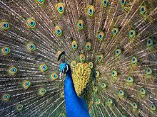
Blue peacock
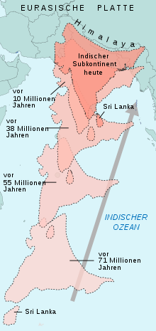
Indian Plate Displacement
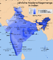
Annual rainfall in India
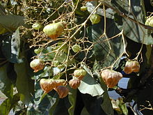
Leaves and fruits of the teak tree
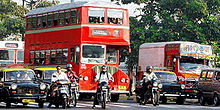
Growing traffic contributes to air pollution in major cities
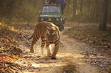
A Royal or Bengal tiger in Kanha National Park, India's "national animal".
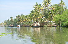
In the backwaters of Kerala
.png)
Important rivers in India
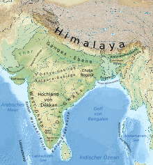
Topographic map of India
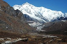
The Kangchendzönga, with 8586 m India's highest mountain
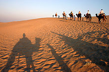
Thar Desert in Rajasthan
Questions and Answers
Q: What is India's official name?
A: The official name of India is the Republic of India (Hindi: Bhārat Gaṇarājya). It is also known as Hindustan or Bhārat within the country.
Q: How many people live in India?
A: India is the second largest country by number of people in the world.
Q: What are India's neighbors?
A: India has six neighbors - Pakistan in the north-west, China, Nepal, and Bhutan in the north, and Bangladesh and Myanmar in the east. Sri Lanka is nearby to the south.
Q: What is India's capital city?
A: The capital city of India is New Delhi.
Q: Is India a nuclear weapon state?
A: Yes, India is a nuclear weapon state.
Q: What are some social and economic issues facing India today?
A: Some social and economic issues facing India today include poverty and corruption.
Q:What religions are practiced inIndia? A:People of many different religions live there, including Hinduism, Buddhism, Jainism, Sikhism, Islam and Christianity. The first four religions originated from the Indian subcontinent
Search within the encyclopedia