Indian subcontinent: geography, geology, and cultural region
The Indian subcontinent is a distinct South Asian landmass bounded by the Himalayas and surrounding seas, home to varied climates, large river systems, deep geological history, and diverse cultures and ecosystems.
Overview
The Indian subcontinent is a large peninsula and cultural region at the southern end of Asia. Politically and commonly it comprises the modern states of Bangladesh, Bhutan, the Maldives, Nepal, Pakistan, Sri Lanka and, centrally, the Republic of India. To the south the landmass is flanked by the Indian Ocean and to the east by the Bay of Bengal. This grouping is used for geographic, ecological and historical discussion rather than representing a single political unit.
Image gallery
5 Images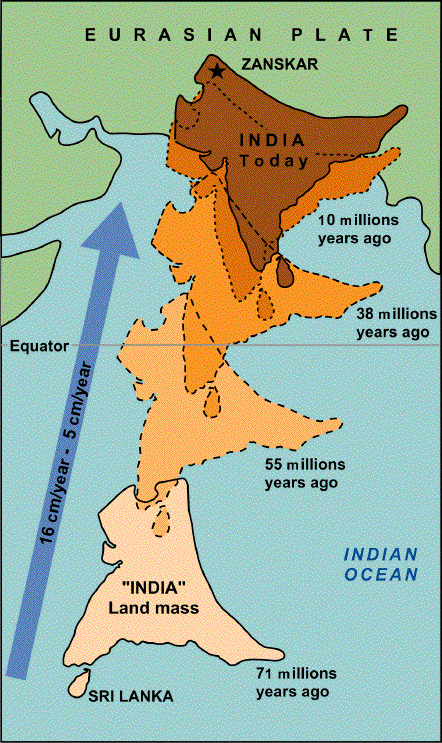


Geography and boundaries
The subcontinent is separated from the rest of Asia by high mountain ranges to the north. The most prominent of these is the Himalayas, which create a climatic and ecological barrier. River systems that originate or run off the mountain slopes—most notably the Ganges and Indus systems—have shaped plains that support dense populations and long agricultural traditions. The zone includes coastal plains, plateaus, deserts and tropical forests, producing a wide range of habitats within a relatively compact area.
Geological origin and development
Geologically, the Indian subcontinent represents a piece of continental crust that has had an active and mobile history. It was once part of the ancient landmass often called Gondwana, a southern supercontinent. Over tens of millions of years the Indian plate moved northward and eventually collided with the Eurasian plate. That collision closed what geologists call the Tethys Ocean and uplifted seabed and marine sediments into mountain chains. Evidence for this history includes marine and sedimentary rocks now found at high elevation and the presence of ancient volcanic and tectonic features along plate margins.
Rocks that formed on ancient sea floors have been raised to great height; for example, some high peaks contain marine fossils and layers of limestone, testimony to their oceanic origin. The continuing convergence between the Indian region and Asia drives deformation at the edges of the plate, with processes such as thrusting along mountain fronts and uplift of the Tibetan Plateau. These movements also make the region seismically active and liable to earthquakes.
Climate, ecosystems and human presence
The subcontinent supports a wide set of climates from tropical coasts to alpine highlands. Seasonal monsoon winds deliver much of the annual rainfall to large areas and play a central role in agriculture and hydrology. A mosaic of ecosystems—mangroves, dry deciduous forests, tropical rainforests, grasslands and alpine meadows—hosts high biodiversity and many endemic species. Human settlement is ancient and continuous: river valleys gave rise to early urban centres, long-distance trade routes connected coastal ports, and the region has been a crossroads for ideas, languages and religions.
Importance and distinctions
The Indian subcontinent is significant as both a distinct geological entity and a cultural region. Its complex terrain and climate have fostered varied modes of life and riches in natural resources, while its long history of kingdoms, empires and colonial encounters produced dense historical records and diverse contemporary societies. Today the subcontinent remains important for its economic activity, cultural influence, and strategic position between the oceans and continental Asia.
Key features at a glance
- Major countries often included: Bangladesh, Bhutan, Maldives, Nepal, Pakistan, Sri Lanka and India.
- Bounded by the Himalayas to the north and the Indian Ocean to the south; the Bay of Bengal lies to the east.
- Geological heritage: remnants of Gondwana and closure of the Tethys Ocean, illustrated by uplifted sedimentary rocks and former volcanic margins.
- Ongoing tectonics drive uplift, thrusting and seismicity; high-altitude rocks contain marine fossils and limestone.
The Indian subcontinent remains a subject of study across geology, ecology, history and social sciences because its physical formation and cultural development are tightly interwoven and continue to influence life across South Asia.

Questions and answers
Q: What is the Indian subcontinent?
A: The Indian subcontinent is a geographic region which includes Bangladesh, Bhutan, Republic of India, Maldives, Nepal, Pakistan and Sri Lanka. It is south of the Himalayas and was once part of Gondwana, an ancient southern supercontinent.
Q: How were the Himalayas formed?
A: The Himalayas were formed when the Indian tectonic plate travelled northward at 15 cm per year to slowly squeeze the Eurasian continent about 40-50 million years ago. This process caused the rock of seabeds from that time to be uplifted into mountains.
Q: What happened to the Tethys Ocean?
A: About 50 million years ago, this fast moving plate had completely closed off the Tethys Ocean. Evidence for its existence can be found in sedimentary rocks settled on its ocean floor and volcanoes that fringed its edges.
Q: How fast is the Indo-Australian plate moving?
A: The Indo-Australian plate is currently moving at 67 mm per year. Over the next 10 million years it may travel about 1,500 km into Asia.
Q: How does this movement affect the Himalayas?
A: About 20 mm per year of India-Asia convergence is absorbed by thrusting along the Himalaya southern front which leads to them rising by about 5 mm per year making them geologically active.
Q: What other effects does this movement have?
A: This movement also causes earthquakes from time to time due to pressure being put on land masses as they move towards each other.
Related articles
Author
AlegsaOnline.com Indian subcontinent: geography, geology, and cultural region Leandro Alegsa
URL: https://en.alegsaonline.com/art/47137
Sources
- eurekalert.org : "The fastest continent: India's truncated lithospheric roots"
- geology.about.com : A site which uses this dramatic fact first used in illustration of "deep time" in John McPhee's book Basin and Range
- ui.adsabs.harvard.edu : 2007Natur.449..894K
- doi.org : 10.1038/nature06214