Nanga Parbat: geography, climbing history and significance
Nanga Parbat (8,126 m) is the ninth-highest mountain, a remote peak in Gilgit‑Baltistan famed for its steep faces, difficult routes and early 20th‑century climbing history that earned it the nickname “Killer Mountain.”
Overview
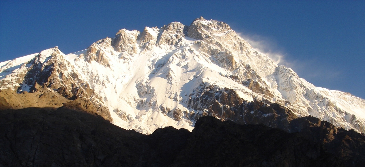
Nanga Parbat rises to 8,126 metres above sea level and is the ninth-highest mountain on Earth. Its name is commonly translated as "Naked Mountain," a reference to its exposed upper slopes. The massif dominates a remote section of northern Pakistan and is a landmark for both geographic and mountaineering history. The mountain’s dramatic relief, especially the towering Rupal Face, and its position at the western edge of the high Himalaya have long made it an object of fascination and danger.
Image gallery
10 Images


Location and geography
Nanga Parbat stands in Gilgit‑Baltistan, between the towns of Chilas and Astore, and within the Astore District. It sits just south of the Indus River and near the western end of the Karakoram, forming the most westerly of the peaks higher than 8,000 metres and marking the western margin of the Himalayas. The Nanga Parbat Range is a compact chain roughly 120 miles (about 190 km) in length and 12–24 miles (19–39 km) in width, joining toward the east with parts of the Pir Panjal Range (range details).
Topography, glaciers and faces
The peak presents several great faces and ridges: the south‑facing Rupal Face, the steep Diamir (west) flank, and the Rakhiot (north‑east) side. The Rupal Face rises in enormous vertical relief from valley floor to summit and is often cited as one of the highest mountain faces in the world. Glaciers descend from these flanks into deep valleys, creating complex access approaches and a range of objective hazards such as avalanches, serac fall and unstable cornices.
Climbing history and routes
Attempts on Nanga Parbat began in the early 20th century and increased in the 1930s. Several pre‑war and wartime expeditions, including those organised from German‑speaking Europe, suffered heavy losses and severe setbacks; this fraught early history helped produce the mountain’s grim popular epithet, the "Killer Mountain." The first confirmed ascent was completed in 1953 by the Austrian climber Hermann Buhl, who reached the summit after a demanding climb that included a bold solo finish. Main modern approaches use the Diamir (western) and Rupal (southern) routes, while the Rakhiot side provides alternative lines; each requires technical high‑altitude climbing, glacier travel and careful acclimatisation.
Risks, advances and modern significance
Nanga Parbat’s combination of steep rock and ice, long approach marches and highly changeable weather keeps it among the more serious objectives in high‑altitude alpinism. Improvements in equipment, forecasting and route knowledge have reduced some historical dangers, but avalanches and objective hazards still cause fatalities. The mountain’s history influenced developments in expedition organisation, acclimatisation practice and high‑altitude rescue techniques. Today it remains an important test for experienced climbers and continues to attract attention from mountaineers, geologists and regional travellers.
Cultural and regional context
Nanga Parbat lies within a region of complex geography and political history associated with Kashmir. Its remoteness, dramatic presence and role in early Himalayan exploration have made it a powerful symbol in mountaineering literature and a focus for local tourism and research. For more detailed route descriptions, historical accounts and current access guidance consult specialised climbing guides and regional sources, and local authorities in Gilgit‑Baltistan and the Astore District.
Further reading and resources
- Overview of the mountain and region: Gilgit‑Baltistan.
- Biographical and ascent accounts: Hermann Buhl and contemporary expedition narratives.
- Historical context of early German‑language expeditions: German expeditions in the 1930s.
- Physical setting: Himalayas, Karakoram adjacency, and the Pir Panjal Range.
- Local geography and rivers: Indus River, Astore District.
- Range measurements and technical details: range details.
- Nickname, legacy and cultural references: killer mountain nickname.
Related articles
Author
AlegsaOnline.com Nanga Parbat: geography, climbing history and significance Leandro Alegsa
URL: https://en.alegsaonline.com/art/68244
Sources
- britannica.com : "Nanga Parbat"