Himalayas: geography, origins, ecosystems and human importance
The Himalayas are the great mountain system of South Asia. This article explains their geography, geological origin, major peaks and rivers, ecological zones, human uses, and contemporary challenges.
The Himalayas are the highest and one of the most extensive mountain systems on Earth. Stretching across much of South Asia, the chain forms a vast arc that separates the plains of the Indian subcontinent from the high Tibetan Plateau. The range contains many of the world’s tallest peaks and is the source of major river systems that sustain hundreds of millions of people. For a broad view of its position and extent see a regional map.
Image gallery
10 Images


Geography and major features
The Himalayan system spans several countries and many subregions. From the western end it approaches Pakistan, runs along the length of northern India (including states such as Jammu and Kashmir, Himachal Pradesh, Uttarakhand, Sikkim, and Arunachal Pradesh), continues through Nepal and Bhutan, and meets the elevated regions of Tibet to the north. Geographers often divide the chain into three main parallel belts: the high or Greater Himalaya (Himadri), the Middle or Lesser Himalaya (Himachal), and the outer foothills known as the Siwalik or Shiwalik range.
Formation and geological history
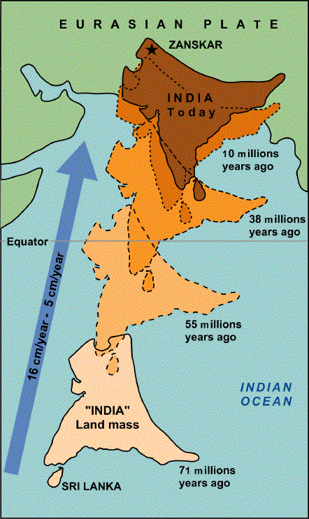
The range formed by the collision of the Indian tectonic plate with the Eurasian plate, a process that began tens of millions of years ago and continues today. Ongoing plate convergence lifts peaks and creates intense seismic activity across the region. The massif preserves a record of tectonic uplift, folded strata and some of the highest peaks on Earth, among them Mount Everest, and notable mountains such as Annapurna and Nanga Parbat. The name "Himalaya" derives from an ancient language and is commonly rendered in English as meaning "House of Snow" from Sanskrit.
Climate, glaciers and rivers
The Himalayas have a strong influence on regional climate. To their north lies the high Tibetan Plateau, often called the "roof of the world," while the southern slopes receive heavy monsoon precipitation. The mountains create a rain shadow effect that helps shape climate patterns across Asia and blocks frigid winds from Central Asia. The monsoon from the Bay of Bengal delivers moisture that is forced to rise and cool over the Himalayas, shedding rain and snow along its flanks; this interaction with the Bay of Bengal Monsoon branch is a central feature of the region’s weather.
Ecology, resources and human uses
Altitude gradients in the Himalayas create a wide range of ecological zones, from subtropical forests at lower elevations to alpine meadows and permanent ice above. Glaciers and snowfields feed some of Asia’s great rivers — notably tributaries of the Indus, Ganges and Brahmaputra systems — and provide freshwater for irrigation, hydropower and domestic use. The mountains support unique biodiversity and many cultural landscapes: pastoralism, terrace farming, pilgrimage routes and mountain tourism are important livelihoods. Peaks and passes are also historically significant corridors for trade, religion and cultural exchange between south and east Asia.
Risks and conservation
The Himalayas face environmental pressures from warming temperatures, glacier retreat, deforestation, infrastructure development and intensifying tourism. Natural hazards include earthquakes, landslides and glacial lake outburst floods, all of which threaten communities and infrastructure. Conservation efforts focus on protecting habitats, sustainable water management and disaster risk reduction while balancing the needs of local populations and cross-border cooperation.
- Major countries crossed: Pakistan, India, Nepal, Bhutan, Tibet/China.
- Commonly cited peak: Mount Everest (about 8,849 m).
- Three traditional belts: Himadri (Greater), Himachal (Lesser), Shiwalik (Outer).
Outline
The High Himalaya in the proper sense are the mountain ranges, up to more than 8000 m high, which extend between the hill zones of the Ganges lowlands and the longitudinal furrow of the headwaters of the Indus and Brahmaputra (Tsangpo: Mazang/Damqog/Mǎquán and Yarlung/Yǎlǔ Zàngbù, respectively). To the north, the High Himalaya is separated by the Indus-Brahmaputra line from the Transhimalayan range (consisting of Gangdisê and Nyainqêntanglha), the fringe mountains of the Tibetan Plateau. The Himalayas reach their greatest heights in the north. The southern foothills of the Himalaya, which accompany it along its entire length, are called Siwaliks (also Churia or Margalla Hills). They are separated from the main ranges by the zones of the Inner Terai. To the south, these strike out in the Bhabhar and Terai belts. In addition, the chains of the Southern Himalaya, which only reach heights comparable to the Alps, are distinguished from the High Himalaya as the Front Himalaya (Lesser Himalaya "Little Himalaya").
enlarge and show information about the picture
![]()
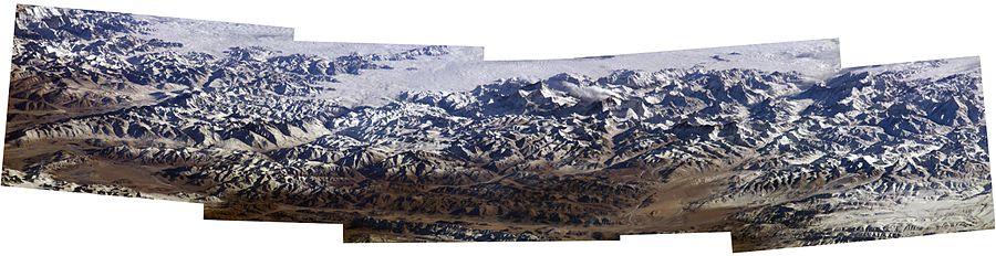
Panorama of the Himalayas taken by an astronaut on board the International Space Station (ISS)
serves for image positioning, please do not remove
Geology
The Himalayas are the largest currently existing mountain range on earth. The mountain ranges tectonically connected with it, such as the Karakorum Mountains, have peaks of over 8000 meters high. They form part of the alpine mountain belt and are among the youngest high mountains on earth.
The Himalayas are a folded mountain range formed as a result of the plate collision of India with Eurasia. When the Indian landmass broke away from Gondwana about 200 million years ago, the Tethys Ocean lay between the Indian and Eurasian landmasses. The Indian drifted northward at a rate of about 9 meters per century, covering about 6400 kilometers, and rammed into the Eurasian plate about 40 to 50 million years ago. The collision slowed the rate of northward drift by half to about 5 centimeters per year and is considered the beginning of the rapid uplift of the Himalayas. The drift continues to this day and is so strong that the Himalayas are rising more than a centimeter per year. This is equivalent to a height increase of 10 kilometers in a million years. Since the collision, India has pushed itself another 2000 kilometers into Asia. This process has resulted in strong earthquakes, displacements and folding, the effects of which are noticeable far into China and Southeast Asia. The Nanga Parbat area of Pakistan has been uplifted more than 10 kilometers in less than 10 million years. Today's rates of uplift of the Himalayas are still remarkable. Even severe erosion could not keep pace with this. Nevertheless, the southern slope of the Himalayas is surrounded by large alluvial cones with fluvial deposits (molasse); these form the Siwaliks.
Although the Himalayas are the highest elevation on the Earth's surface, they are not the furthest place on the Earth's surface from the center of the Earth.


Questions and answers
Q: Where are the Himalayas located?
A: The Himalayas are a mountain range in South Asia. They run through Jammu and Kashmir, Himachal Pradesh, Uttarakhand, Sikkim and Arunachal Pradesh states in India, Nepal, and Bhutan. The west end is in Pakistan and the east end is in the south of Tibet.
Q: What is the highest mountain peak in the world?
A: Mount Everest is the highest mountain on Earth, at 8,849 meters.
Q: How many of the fifteen highest mountains peaks are located in the Nepali Himalayas?
A: Nine of the fifteen highest mountain peaks in the World are located in the Nepali Himalayas.
Q: What does "Himalaya" mean?
A: The word "Himalaya" means House of Snow in Sanskrit, an old Indian language.
Q: How has this mountain range influenced climate patterns?
A: The Himalayas have greatly influenced climate patterns by blocking extremely cold winter winds from Central Asia from entering Subcontinent and forcing Bay of Bengal Monsoon branch to shed its moisture along NE and Northern Indian States, Bhutan, Nepal and Bangladesh.
Q: What lies north of this mountain range?
A: North of the Himalayas is the Tibetan Plateau which is often referred to as “the roof of the world”.
Q: Why is it called “the roof of world”?
A: It's called “the roof of world” because it's very high up but also very dry due to acting as a gigantic rain shadow that forces rain to fall on south side instead.
Related articles
Author
AlegsaOnline.com Himalayas: geography, origins, ecosystems and human importance Leandro Alegsa
URL: https://en.alegsaonline.com/art/44255
Sources
- geology.about.com : A site which uses this dramatic fact first used in illustration of "deep time" in John McPhee's book Basin and Range
- kwintessential.co.uk : "Fun facts about the Himalayas"
- himalaya2000.com : "Wildlife Travel in Himalayas - Himalayan Wildlife Travel - Wildlife in Himalaya - Himalayan Wildlife Tour"
- commons.wikimedia.org : Himalayas