Lake Lugano — border lake between Switzerland and Italy
Lake Lugano is a glacial subalpine lake on the Swiss–Italian border, noted for its scenic shorelines, mild microclimate, ferry services and mix of Swiss and Italian towns, including the city of Lugano.
Overview
Lake Lugano is a scenic glacial lake that lies on the border between Switzerland and Italy. The body of water takes its name from the city of Lugano and sits geographically between Lake Maggiore and Lake Como. Roughly two thirds of the lake surface is in the Swiss canton of Ticino and about one third in the Italian Lombardy region. It is often described as a subalpine lake with steep shores and an irregular shoreline.
Image gallery
10 Images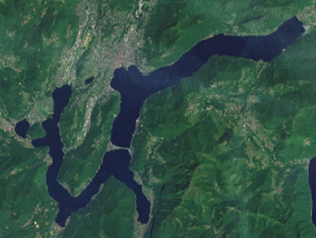


Geography and physical features
The lake is shaped by ancient glaciers and is split into basins separated by narrow channels and peninsulas. A well-known crossing at Melide carries road and rail across a causeway that influences local water circulation. Surrounded by wooded hills and mountains, the shores include a mix of steep rock faces and gentler, built-up promenades at towns.
Several small towns and settlements fringe the water, from larger urban Lugano to smaller villages and one Italian exclave on the lakeshore. The lake drains toward the region of the greater Po basin, with short surface connections linking it into the nearby lake system.
Human use, recreation and transport
Lake Lugano has long been valued for tourism and local transport. Regular ferries and pleasure craft serve passengers and commuters; hiking trails and panoramic viewpoints attract visitors year-round. Popular activities include boating, lakeside promenades, swimming in designated areas and dining in lakeside towns.
- Passenger ferries and boat tours
- Lakeside promenades and parks
- Hiking and viewpoints on surrounding hills
- Local fishing and seasonal swimming
Historically the area developed around trade routes and later as a destination for 19th‑ and 20th‑century tourism, with villas and hotels built on attractive bays. Environmental management has been important in recent decades: municipal sewage treatment, shoreline planning and water quality monitoring aim to balance tourism, transport and habitat conservation while preserving the lake’s characteristic mild microclimate.
Related articles
Author
AlegsaOnline.com Lake Lugano — border lake between Switzerland and Italy Leandro Alegsa
URL: https://en.alegsaonline.com/art/55519
Sources
- commons.wikimedia.org : Lake Lugano