
Lake Marion (South Carolina): history, features, and recreation
Lake Marion is South Carolina's largest lake, an inland sea formed by damming the Santee River in the 1940s. It supports hydroelectric power, navigation, fisheries and year-round recreation.
Overview
Lake Marion is the largest reservoir in South Carolina, often called the state's "inland sea" for its broad open water and extensive shoreline. Created during the mid-20th century, the lake covers roughly 110,000 acres (about 450 km²) and offers more than 300 miles of shoreline where river valleys, marshes and low rolling farmland meet a large freshwater basin. Parts of the lake lie within five different counties, making it a regional natural and economic resource.
Image gallery
2 Images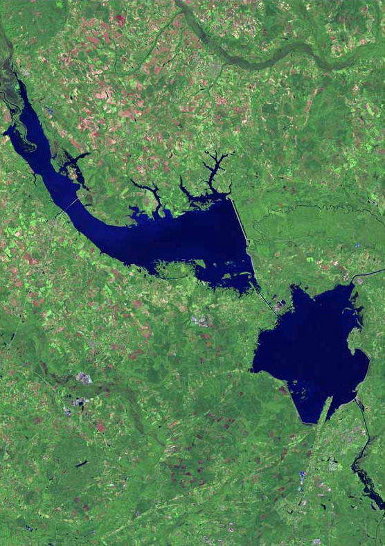

Formation and history
Lake Marion was formed when the Santee River system was impounded as part of a large public works project in the 1930s–1940s intended to provide electricity and improve navigation. The effort was associated with national rural electrification and economic recovery programs during the administration of Franklin D. Roosevelt and the era of the Great Depression. Impoundment altered the landscape—flooding lowlands and creating a reservoir that would serve multiple purposes including power generation, flood control, transport, and recreation.
Physical characteristics and infrastructure
As a large man-made lake, Lake Marion functions as part of a linked waterway network. Water from the lake can be routed through the Diversion Canal into Lake Moultrie, and navigation between basins is controlled by a lock system. At the downstream end where Lake Moultrie flows toward the coast, the Pinopolis Lock lowers vessels to the Tailrace Canal that connects with the Cooper River and ultimately leads toward Charleston. The impoundments created by the project also host hydroelectric facilities that were a key justification for their construction.
Ecology, wildlife and fishing
Lake Marion supports a varied freshwater ecosystem. Shallow flats, drowned timber, and marshy margins provide habitat for waterfowl, wading birds and a range of fish species. The lake is popular with anglers seeking largemouth bass, crappie, catfish and other sport and panfish; managed fisheries and breeding habitat make it an important recreational fishery in the region. Nearby protected areas and wetland tracts support migratory birds and local biodiversity.
Uses, recreation and local importance
The lake is used year-round for boating, fishing, hunting, camping and wildlife viewing. Commercial and recreational boating benefit from the inland waterway connection to coastal rivers. Shoreline communities and tourism businesses rely on the lake for economic activity, while the reservoir continues to contribute to regional power supply and water management. Because of its size and open water, Lake Marion is a focal point for events, tournaments and outdoor education in the central part of the state.
Notable facts and distinctions
- Lake Marion is frequently described as South Carolina's "inland sea" due to its large surface area and expansive horizons.
- It ranks among the largest lakes in the United States when natural and man-made reservoirs are combined; for broader context see resources that list major U.S. reservoirs and lakes (rankings and data).
- The Santee Cooper impoundment system that created Lake Marion remains an example of multi-purpose water resource development from the mid-20th century.
Practical information
Visitors typically reach public boat ramps, marinas and parks located around the lake's perimeter; seasonal regulations apply for fishing and hunting, and safety advisories are posted for boating. For maps, access points and official guidance consult regional recreational resources and local authorities before planning a visit.
Questions and answers
Q: What is Lake Marion?
A: Lake Marion is the largest lake in South Carolina and is referred to as South Carolina's inland sea.
Q: How large is Lake Marion?
A: Lake Marion covers almost 110,000 acres (450 square kilometers or 173.7 square miles) of rolling farmlands, former marshes, and river valley landscape.
Q: What is the shoreline length of Lake Marion?
A: Lake Marion has a 315-mile (507-kilometre) shoreline.
Q: Why was the Santee River dammed in the 1940s?
A: The Santee River was dammed in the 1940s to supply hydroelectric power.
Q: What was the purpose of damming the Santee River in the 1940s?
A: Damming the Santee River was part of the rural electrification efforts initiated under President Franklin D. Roosevelt's New Deal during the Great Depression.
Q: What can visitors do at Lake Marion?
A: Visitors can travel from Lake Marion through the Diversion Canal to Lake Moultrie.
Q: Where can boaters go from the end of Lake Moultrie?
A: At the end of Lake Moultrie lies the 75-foot high Pinopolis Lock which will lower boaters down to the Tailrace Canal which takes you to the Cooper River and on to Charleston.
Related articles
Author
AlegsaOnline.com Lake Marion (South Carolina): history, features, and recreation Leandro Alegsa
URL: https://en.alegsaonline.com/art/55526