
Lake Maracaibo — Venezuela’s brackish bay and estuarine basin
Large brackish tidal bay in northwestern Venezuela, connected to the Caribbean Sea; notable for its size, inflowing rivers (including the Catatumbo), rich ecology, oil industry and unique weather.
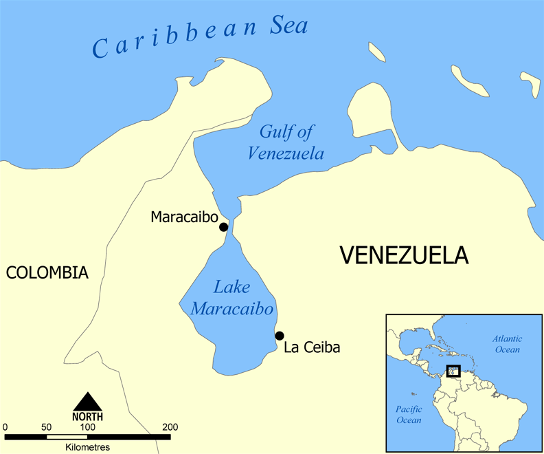
Lake Maracaibo (Spanish: Lago de Maracaibo) is a broad, shallow estuarine basin in northwestern Venezuela. Geographically and culturally it is often called a lake, but scientifically it functions as a large tidal estuary or inlet of the Caribbean Sea. A natural channel about 55 km long connects the basin to the open sea, producing tides and a salinity gradient that distinguish the northern and southern parts of the system.
Image gallery
10 Images




Physical characteristics
Lake Maracaibo covers an irregular area that measures roughly 160 km by 110 km at its greatest extents and receives freshwater from many rivers. Some sources indicate about 135 tributaries empty into the basin. The largest feeder is the Catatumbo River, which drains a wide catchment and is responsible for a large share of the lake’s inflow. The northern reaches are influenced by marine water and are brackish, while the more southerly zones tend toward freshwater, producing a pronounced salinity gradient and diverse habitats.
Islands, shoreline and human infrastructure
The basin contains numerous islands and marshy shorelines. The city of Maracaibo, on the eastern side of the northern channel, is the region’s principal urban center; at the channel the span is about 8.5 km wide and is crossed by the long General Rafael Urdaneta Bridge. Because the waterway links to the Caribbean it supports local navigation, fishing communities and ports serving the surrounding lowlands.
Ecology and notable phenomena
Salinity gradients, tidal mixing and freshwater inflow create varied ecological zones from mangrove fringes to brackish marshes and open-water habitats. The lake’s productivity supports fish and bird life important to local fisheries, though habitats have been altered by development and pollution. The mouth of the Catatumbo basin is famous for the Catatumbo lightning, a persistent, localized display of storms and lightning that has cultural and scientific interest.
History, resources and environmental concerns
Human settlement around the basin dates back centuries, and the area rose in global importance with the discovery and exploitation of petroleum in the 20th century. The lake and adjacent fields have been central to Venezuela’s oil industry, bringing economic growth but also environmental pressures. Oil extraction, spills, agricultural runoff and urban wastewater have contributed to contamination, eutrophication and changes in aquatic life. Conservation and remediation efforts are ongoing amid competing social and economic priorities.
Quick facts and distinctions
- Also described as a bay or lagoon in different contexts, reflecting its mixed marine and freshwater characteristics.
- Approximately 55 km long sea channel connects the basin to the Caribbean Sea.
- Receives inflow from many rivers, the principal being the Catatumbo River.
- The northern sector is predominantly brackish, while the southern reaches are more freshwater.
- Major urban and industrial presence near Maracaibo shapes both economy and environmental risk.
Lake Maracaibo remains a geographically and economically significant body of water in Venezuela: a hybrid system where marine, fluvial and human factors combine to create complex ecological dynamics and pressing management challenges.
Questions and answers
Q: What is Lake Maracaibo?
A: Lake Maracaibo is a large brackish tidal bay (or tidal estuary) in Venezuela.
Q: What connects Lake Maracaibo to the Caribbean Sea?
A: A channel 55 km long connects Lake Maracaibo to the Caribbean Sea.
Q: Why is Lake Maracaibo often called a lake rather than a bay or lagoon?
A: Despite being a tidal bay, Lake Maracaibo is often called a lake because of its large size and unique characteristics.
Q: What is the name of the city on the east side of the channel that connects Lake Maracaibo to the Caribbean Sea?
A: The city on the east side of the channel is named Maracaibo.
Q: What river is the biggest one flowing into Lake Maracaibo?
A: The biggest river flowing into Lake Maracaibo is Catatumbo River, which is 500 km long.
Q: Is the northern part of Lake Maracaibo brackish water or freshwater?
A: The northern part of Lake Maracaibo is brackish water.
Q: Are there any islands in Lake Maracaibo?
A: Yes, there are many islands in Lake Maracaibo.
Related articles
Author
AlegsaOnline.com Lake Maracaibo — Venezuela’s brackish bay and estuarine basin Leandro Alegsa
URL: https://en.alegsaonline.com/art/55525
Sources
- britannica.com : "Lake Maracaibo"
- merriam-webster.com : Webster's New Geographical Dictionary
- qunlimited.com : "Who Wants to Be a Judge at the National Academic Championship?"
- icb.oxfordjournals.org : "Marine Invasions by Non-Sea Snakes, with Thoughts on Terrestrial–Aquatic–Marine Transitions"
- doi.org : 10.1093/icb/ics060
- theguardian.com : "Venezuela's nightly lightning show"
- bartleby.com : Maracaibo, Lake · web.archive.org
- sciencedirect.com : "Hydrogeochemical characterization of oilfield waters from southeast Maracaibo Basin (Venezuela): Diagenetic effects on chemical and isotopic composition"
- doi.org : 10.1016/j.marpetgeo.2016.02.020
- worldlakes.org : "LakeNet - Lakes"
- doi.org : 10.1175/BAMS-D-14-00193.1