
Hurricane Humberto (2007)
A fast-forming Category 1 hurricane that developed in the northwestern Gulf of Mexico on September 12–13, 2007, striking near High Island, Texas, and causing localized damage estimated at around $50 million.
Overview: Hurricane Humberto was a compact, rapidly forming tropical cyclone that developed in the northwestern Gulf of Mexico in mid-September 2007 and reached hurricane strength within a matter of hours before striking the upper Texas coast. Its unusually quick intensification attracted attention because it became a hurricane on a timescale that set a noteworthy record for rapid strengthening, and is often cited in discussions of short‑fuse tropical cyclone development and warning challenges. Humberto was the eighth named storm and the third hurricane of the 2007 Atlantic hurricane season, and marked the first hurricane to make United States landfall since Hurricane Wilma in 2005. Damage from Humberto was comparatively modest, with estimates near $50 million.
Image gallery
9 Images


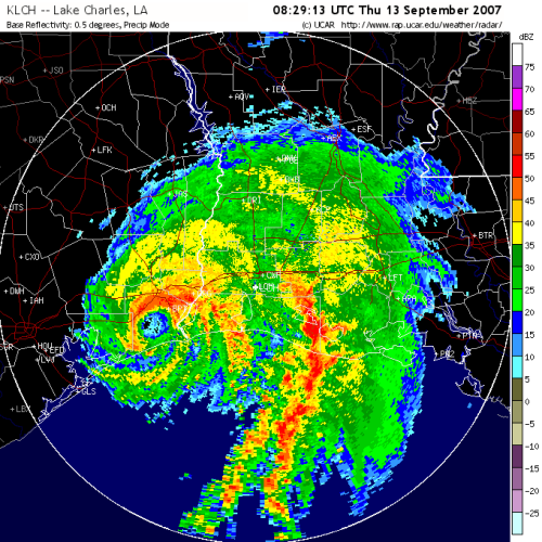
Meteorological history and characteristics
Humberto formed from a low‑pressure disturbance that organized over the warm waters of the northwestern Gulf of Mexico on September 12. The system consolidated rapidly and achieved tropical-storm and then hurricane intensity in a span of hours, prompting characterization of its intensification as among the fastest on record by some operational and post‑storm analyses (official records). It made landfall on the upper Texas coast near High Island with maximum sustained winds near 90 mph (about 150 km/h), enough to classify it as a Category 1 hurricane at the moment of impact. After moving inland the cyclone weakened steadily and was absorbed by an approaching cold front, dissipating over northwestern Georgia on September 14.
Two features notable in Humberto's brief life were its small overall wind field and the proximity of its formation to land. Both factors limited the window for forecasting and public warnings: because the storm organized so close to the coast, there was little lead time between classification as a tropical cyclone and landfall. That circumstance has since been used as a case study in improving rapid‑intensification monitoring and short‑range forecasting.
Impact and aftermath
Impacts from Humberto were concentrated on the upper Texas coast and adjacent inland counties. Coastal areas experienced storm surge and beach erosion, while wind gusts and falling trees caused localized structural damage and widespread power outages. Heavy rain produced pockets of freshwater flooding inland. Official damage estimates placed the total cost at roughly $50 million, reflecting mostly property and infrastructure damage rather than catastrophic losses. There was no widely reported, large‑scale loss of life associated with the storm.
Emergency responses emphasized rapid assessment and restoration of services; the event reinforced the importance of preparedness for even small or short‑lived storms. Because Humberto was brief and of moderate intensity, its name was not retired from the rotating Atlantic list of storm names.
Timeline and notable points
- September 12, 2007: Disturbance organizes in the northwestern Gulf and quickly becomes a tropical cyclone.
- September 12–13: System intensifies rapidly; hurricane status declared within hours, an event often cited in discussions of the fastest intensification recorded for a storm so close to land.
- Early September 13: Humberto makes landfall near High Island, Texas, with winds near 90 mph.
- September 14: The cyclone weakens inland and dissipates over northwestern Georgia while interacting with an approaching frontal system.
- Contextual notes: Humberto was the eighth named storm and third hurricane of the 2007 season, and the first U.S. landfalling hurricane since Wilma in 2005 — a reminder of multi‑year variations in U.S. hurricane impacts (U.S. landfall context).
- Post‑event analyses highlighted the challenges short‑fuse storms pose to warnings and response planning, and have informed subsequent improvements in satellite monitoring and rapid‑intensification guidance (landfall timing studies).
Hurricane Humberto (2007) remains a frequently cited example in meteorology of how a tropical cyclone can develop and strengthen on a very short timeline, underlining the need for continuous monitoring of near‑coast disturbances and clear public messaging when storms organize close to shore.
Related articles
Author
AlegsaOnline.com Hurricane Humberto (2007) Leandro Alegsa
URL: https://en.alegsaonline.com/art/45906
Sources
- nhc.noaa.gov : "Hurricane Humberto Tropical Cyclone Report"