Golan Heights: geography, history, and contemporary status
Overview of the Golan Heights: geography, environment, modern history, political status, population, economy and strategic importance in regional diplomacy.
Overview
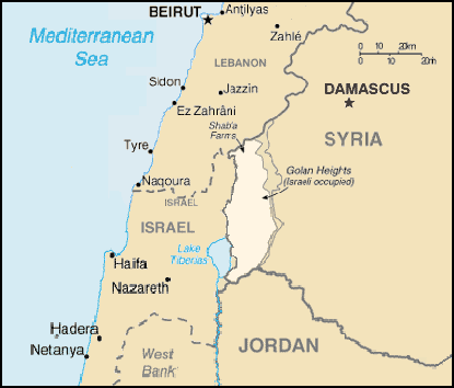
The Golan Heights is a volcanic plateau in the Levant that rises to the east of the Sea of Galilee and forms part of the borderlands between the modern states of Israel and Syria. Its high ground and water resources have shaped its strategic importance through modern history. The United Nations has repeatedly addressed the status of the territory and the need for peaceful resolution of disputes; the United Nations remains a reference point for international positions and peacekeeping arrangements.
Image gallery
10 Images


Geography and environment
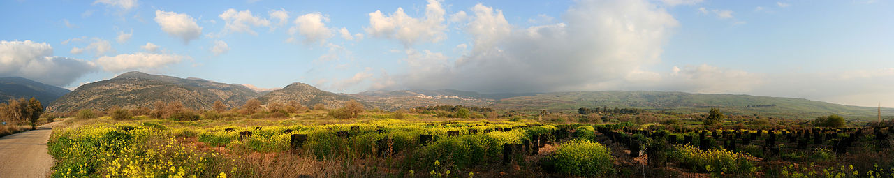
The Golan is a basaltic plateau that drops steeply to the Hula Valley and the Sea of Galilee in the west and slopes toward the Syrian desert in the east. The highest massif in the region is Mount Hermon, whose upper reaches receive more precipitation and occasional snow. The western rim is marked by a chain of volcanic cones and lava fields; many of these features are considered dormant or extinct volcanoes rather than active systems. Streams and springs on the plateau contribute to the Jordan River basin and to water storage that is significant for agriculture and local supply.
Historical outline
Before the 20th century the area formed part of successive regional administrations; in modern times it was under Ottoman rule and later administered within the French mandate system until the mid-20th century. Following the creation of the modern states in the region, the Golan was administered by Syria. During the 1967 Six-Day War Israeli forces captured the plateau, and fighting resumed in 1973. A United Nations–supervised disengagement created a buffer monitored by observers.
Political status and law
In 1981 Israel extended its civil law to the Golan in a step commonly described as an annexation; this move was not accepted by the United Nations or most countries, which continue to regard the territory as occupied under international law. Sporadic negotiations toward a formal peace treaty with Syria have taken place but have not resulted in a final settlement. Some states have at times changed their official positions, reflecting shifting diplomatic priorities.
Population, economy and administration
The plateau is inhabited by a mix of communities: Israeli civilian settlements, agricultural enterprises, and local Arab residents including Druze villages that maintain distinct social and cultural ties. Different communities live under different administrative and legal arrangements, and political preferences vary. The local economy relies on agriculture, orchards, vineyards and tourism related to natural and historical sites; water management and land use are central to livelihoods.
Strategic significance and current issues
Strategically, the heights offer commanding observation and defensive depth above northern Israel and southwest Syria. Control of the plateau has been viewed in military terms as well as through the lenses of water security and civilian safety. Periodic security incidents and the wider conflict in Syria have affected the area and prompted measures to strengthen local defenses. In 2013 the Israeli government announced plans to construct a security barrier and fortifications along the eastern edge of the plateau, including a barrier near the de facto border and related works often described as a wall.
International diplomacy and peace efforts
The international community, through resolutions and negotiations, has emphasized that the status of the Golan should be settled by agreement between the parties. The presence of the United Nations Disengagement Observer Force and ongoing diplomatic activity reflect the continued complexity of achieving a durable settlement. Efforts to balance security, legal claims and the rights and needs of local populations remain central to future arrangements.
- Key geographic feature: Mount Hermon.
- Major international actor: United Nations.
- Principal parties: Israel and Syria.
- Legal issue: annexation and international recognition.
- Security measures: planned fortifications and monitoring of the de facto border.
Further reading and primary documents may be consulted through official channels and archival records; peace proposals and local accounts illustrate the combination of strategic, legal and human factors that continue to shape the Golan's future. International discussion and local developments will determine how the plateau is governed and how the needs of its inhabitants are met.
For more background on negotiation attempts and the regional context see sources that discuss past peace treaty proposals and UN resolutions, and consult analyses addressing the plateau's water resources and geology, including notes on volcanic features and their role in the local landscape.
Related articles
Author
AlegsaOnline.com Golan Heights: geography, history, and contemporary status Leandro Alegsa
URL: https://en.alegsaonline.com/art/39453
Sources
- af.reuters.com : Trump signs decree recognizing Israeli sovereignty over Golan Heights
- apnews.com : "Trump signs declaration reversing US policy on Golan Heights"
- aa.com.tr : Israel to send 250,000 settlers to occupied Golan
- cbs.gov.il : Statistical Abstract of Israel 2018, 2.17
- bbc.com : Golan Heights profile
- britannica.com : "Golan Heights"
- bbc.co.uk : "Profile: Golan Heights"
- un.int : "The Syrian Golan"
- worldnews.nbcnews.com : Israel becomes a fortress nation as it walls itself off from the Arab Spring