
Denmark Strait (Greenland Strait)
Oceanic strait between Greenland and Iceland linking the Greenland Sea and the Irminger Sea; important for ocean circulation, marine ecosystems, navigation history and climate research.
Overview
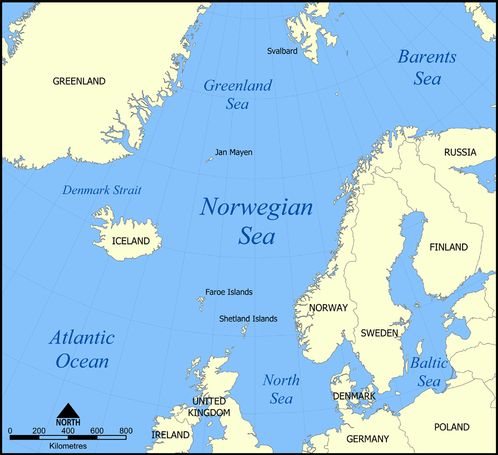
The Denmark Strait, sometimes called the Greenland Strait, separates southwestern Greenland from northeastern Iceland. The remote volcanic island of Jan Mayen, administered by Norway, lies to the northeast of the channel. The strait's approximate central position is around 67°N 24°W.
Image gallery
3 Images
Physical characteristics
The strait links the Greenland Sea, an extension of the Arctic Ocean, with the Irminger Sea, part of the Atlantic Ocean. It is commonly described as roughly 300 miles (about 480 km) long with a narrowest cross‑section on the order of 180 miles (about 290 km). The seafloor has pronounced sills, troughs and steep slopes that control the exchange of water between the Nordic Seas and the North Atlantic.
Oceanography and climate role
The Denmark Strait is a major pathway for dense, cold water flowing southward from the Arctic. This overflow contributes to the formation of intermediate and deep water masses, often termed Denmark Strait Overflow Water (DSOW), which are important components of the North Atlantic branch of the global thermohaline circulation. The strong currents and temperature contrasts in the strait affect local sea‑ice distribution, fog formation and seasonal weather patterns.
Bathymetry and the submarine waterfall
Oceanographers have described dramatic downward flows at the strait where dense water cascades over submarine sills and slopes; this process is sometimes likened to a vast underwater waterfall. These cascading overflows generate turbulent mixing, entrain fresher water and play a role in transporting heat and salt into deeper layers of the Atlantic.
History, navigation and human use
The Denmark Strait has long been crossed by fishing, sealing and transatlantic voyages when conditions allow. It is noted in twentieth‑century naval history as the location of the Battle of the Denmark Strait on 24 May 1941. Modern merchant ships and research vessels transit the area subject to ice, weather and routing considerations.
Ecology, resources and research
Cold, nutrient‑rich waters support productive marine ecosystems adjacent to the strait, including plankton blooms, fish stocks and migratory marine mammals. The region is the focus of ongoing research into climate variability, ocean mixing and the sensitivity of the Atlantic circulation to changing Arctic conditions. Observations from the Denmark Strait help scientists assess long‑term changes in heat, freshwater and carbon transport between the Arctic and Atlantic.
Quick facts
- Connects the Greenland Sea (link) to the Irminger/Atlantic system (link).
- Nearby island: Jan Mayen (administered by Norway).
- Historic event: World War II naval engagement, 24 May 1941.
- Approximate coordinates: 67°N 24°W.
- Often discussed in oceanography for the Denmark Strait Overflow Water (DSOW) and its role in thermohaline circulation.
Related articles
Author
AlegsaOnline.com Denmark Strait (Greenland Strait) Leandro Alegsa
URL: https://en.alegsaonline.com/art/26602