Terrain (Relief): Definition, Components, Measurement, and Uses
Terrain, or relief, describes the vertical dimension and shape of Earth's surface — its heights, slopes and landforms — and how these are measured, represented, and applied in science and planning.
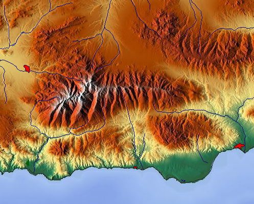
Terrain (also called relief) is the vertical and three-dimensional aspect of the Earth's surface: the patterns of heights, slopes and shapes that make up landscapes. The term emphasizes the "up-and-down" variation of land. When the same concept is applied below sea level it is commonly called bathymetry, and some authors use topography as an equivalent term in everyday use. Terrain is a central concept in physical geography and landscape science because it organizes how water flows, where vegetation grows, and how people use the land. For underwater forms and seafloor mapping see undersea relief.
Image gallery
4 Images


Key characteristics and components
Terrain is typically described by several measurable attributes. These include:
- Elevation — the height of a point above a reference level, most often mean sea level; elevation is a primary scalar descriptor (elevation).
- Slope — the rate of change of elevation with horizontal distance; steepness influences erosion, stability and flow.
- Aspect — the compass direction that a slope faces, which affects sunlight, microclimate and vegetation.
- Relief and ruggedness — the difference between high and low points in an area, and measures of surface roughness.
- Landforms — recognizable features such as valleys, ridges, plateaus, hills and mountains that are building blocks of terrain.
How terrain is measured and represented
Historically terrain was recorded with field surveys and drawn contour maps; modern practice relies heavily on remote sensing and digital models. Contour lines on maps remain a common graphic method to show elevation. Digital Elevation Models (DEMs) and Digital Terrain Models (DTMs) store elevation values in raster or vector form and are derived from satellite imagery, aerial photography and active sensors such as LiDAR and radar. These datasets make it possible to compute slope, aspect, drainage networks and viewsheds automatically. The study of terrain also belongs to the broader discipline of physical geography, which links landform patterns to processes.
History and development
Understanding and mapping terrain has a long history. Early civilizations created simple relief depictions for agriculture and travel. Systematic topographic surveying using triangulation, leveling and later photogrammetry became formalized in the 18th–20th centuries and produced the familiar topographic maps used for planning and navigation. The late 20th and early 21st centuries brought rapid change: satellite remote sensing, global elevation missions and airborne LiDAR allow detailed, near-global elevation products that support modeling at many scales. Practical techniques and terminology have evolved alongside these tools; terms such as "topography" and "terrain" sometimes carry different meanings in different professions.
Uses, importance and examples
Terrain information is essential across many fields. Engineers and planners use elevation data for road design, floodplain mapping and site selection. Hydrologists model how terrain controls surface runoff and watershed boundaries. Ecologists relate species distributions to slope and aspect. Military operations have long depended on terrain analysis for movement and positioning. Terrain also influences local weather and broader climate patterns by affecting airflow, precipitation distribution and solar exposure. Practical examples include predicting landslide risk on steep slopes, routing stormwater in urban areas, and identifying agricultural terraces on hillside farms.
Distinctions and notable considerations
Several distinctions are useful when working with terrain. "Topography" sometimes refers to map representation, while "terrain" emphasizes physical form. Bathymetry is used for underwater relief. Scale matters: microtopography describes small-scale surface features (soil mounds, rills), while regional terrain captures mountain ranges and basins. Models also differ: a Digital Surface Model (DSM) records heights of vegetation and man-made objects, whereas a DTM attempts to represent the bare earth. Quantitative indices — slope distributions, terrain ruggedness, curvature — help summarize complex surfaces for analysis.
For introductory overviews and technical references, readers can consult resources on seafloor mapping (undersea relief), bathymetric methods (bathymetry), topographic concepts (topography), physical geography surveys (physical geography), elevation data (elevation), surveying history (surveying), and environmental impacts on weather and climate.
Related articles
Author
AlegsaOnline.com Terrain (Relief): Definition, Components, Measurement, and Uses Leandro Alegsa
URL: https://en.alegsaonline.com/art/97112