Climate: long-term patterns of weather, types, causes and relevance
Climate is the long-term pattern of weather in a region — averages and ranges of temperature, precipitation, wind and related conditions — shaped by geography, oceans and atmospheric systems.
Climate refers to the typical patterns and long-term averages of atmospheric conditions in a place, including temperature, precipitation, humidity, wind, and air pressure. Where "weather" describes short-term variations, climate summarizes how the atmosphere behaves over decades; many organizations use a thirty-year window to define a region's climate. Understanding climate means describing not only mean values but also seasonal rhythms, extremes, and the variability that affects ecosystems and human systems.
Image gallery
5 Images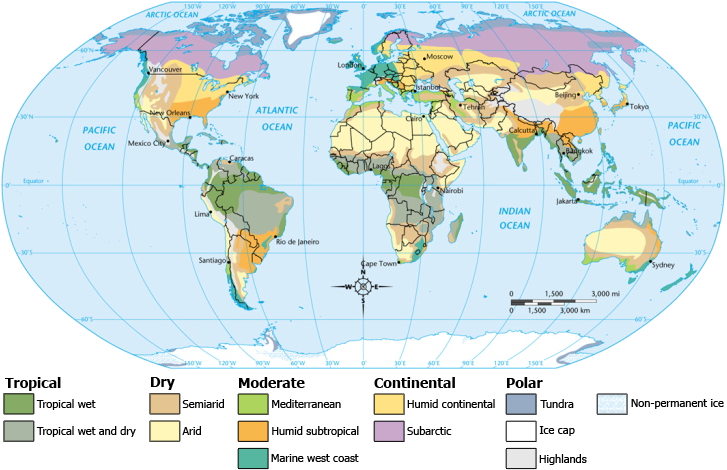


Key components and controlling factors
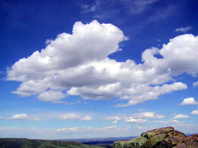
Important components of climate include average and extreme temperatures, total and seasonal precipitation, humidity, prevailing winds, and the frequency of events such as storms. Several physical factors control these components: latitude (which determines solar angle), elevation (which affects temperature and pressure), distance from oceans or large lakes (which moderate temperature), ocean currents, and topography (which can create rain shadows or channel winds). Vegetation, soil type and land use also influence local and regional climates.
Classification schemes
Scientists organize climates into categories to compare regions and study processes. The Köppen classification is widely used and groups climates by temperature and precipitation patterns linked to vegetation zones. Other systems, such as the Thornthwaite system, incorporate water balance and evapotranspiration to assess moisture availability. Synoptic and air‑mass based approaches emphasize the origin and movement of air masses, while modern climatology also relies on long instrumental records and climate models to characterize regimes and change.
Major climate types and examples
- Tropical: consistently warm with distinct wet and dry seasons; typical of equatorial rainforests and monsoon regions.
- Desert/dry: very low precipitation and large daily or seasonal temperature ranges; found in subtropical interiors and rain shadows.
- Temperate: moderate temperatures with four recognizable seasons; common in mid-latitudes.
- Mediterranean: hot, dry summers and cool, wet winters; occurs on western continental margins at certain latitudes.
- Polar/boreal: long, cold winters and brief, cool summers; characteristic of high latitudes and high plateaus.
History of climate science and practical uses
Systematic study of climate developed from regional weather observation and early attempts to relate climate to vegetation and agriculture. Classifications and instruments improved through the 19th and 20th centuries, and today paleoclimate records, satellite data and numerical models extend understanding across time scales. Climate information underpins agriculture, water management, urban planning, infrastructure design, biodiversity conservation and public health planning, because long-term averages and extremes determine suitable crops, building codes and resource strategies.
Change, variability and notable distinctions
Climate varies naturally on multiple time scales — seasonal cycles, year-to-year oscillations, and longer-term shifts recorded in ice cores and sediments. In recent decades, observations and physical theory indicate that human activities, especially greenhouse gas emissions, are contributing to a warming of the global climate system. This change affects the frequency and intensity of extreme events, sea level, and ecosystems. Distinctions often emphasized in climatology include the difference between climate and weather, the concept of microclimates (local departures from regional climate), and the idea of climate normals, which are standard 30-year averages used for comparison.
Further reading and resources
- Climate components and patterns
- Weather versus climate
- Tropical climate characteristics
- Desert and dry climates
- Polar and boreal climates
- Mediterranean climate regions
- Seasonal cycles and their effects
- Climates of Europe and adjacent regions
- Arid regions and adaptations
- African climate zones
- Amazon and tropical rainforest climates
- Mediterranean examples and landscapes
- Latitude and insolation
- Altitude and mountain effects
- Temperature as a classification axis
- Precipitation patterns and measures
- Köppen climate classification
- Evapotranspiration and water balance
- Climate influences on biodiversity
- Air masses and synoptic classification
- Long-term climate change and variability
- Recent trends in global warming
Term
Definition
Depending on the stage of development and the focus of climate research, there were and are different definitions. The Intergovernmental Panel on Climate Change (IPCC) works on the basis of a broad definition:
"Climate in the strict sense is usually defined as the average weather, or more precisely as the statistical description in terms of average and variability of relevant variables over a period of time ranging from months to thousands or millions of years. The classic time period for averaging these variables is 30 years, as defined by the World Meteorological Organization. The relevant variables are mostly surface variables such as temperature, precipitation, and wind. Climate in the broader sense is the state, including a statistical description, of the climate system."
This IPCC definition encompasses a deep time perspective and takes into account other subsystems (Earth spheres) in addition to the atmosphere. It reflects the development since the second half of the 20th century, in which interdisciplinary research into climate dynamics, including its causes, became possible and moved to the forefront of interest. As a result, the temporal dimension gained in importance over the regional dimension.
The German Weather Service (DWD) defines climate more narrowly, with spatial reference and on a time scale of decades:
"Climate is defined as the summary of weather phenomena characterizing the mean state of the atmosphere at a given place or in a more or less extensive area.
It is represented by the overall statistical properties (mean values, extreme values, frequencies, persistence values, etc.) over a sufficiently long period of time. Generally, a period of 30 years is used, the so-called normal period, but shorter periods are also common."
In geographical climatology, climate was defined by Joachim Blüthgen in his General Climatic Geography as follows:
"Geographical climate is the summary, typical of a locality, landscape, or larger area, of the atmospheric conditions and weather processes near and affecting the earth's surface during an extended period of time in characteristic frequency distribution."
In meteorological climatology, climate is defined as follows according to Manfred Hendl:
"Climate is the locally characteristic frequency distribution of atmospheric conditions and processes during a sufficiently long reference period, to be chosen so that the frequency distribution of atmospheric conditions and processes reflects the typical conditions at the reference location."
The definition fundamental to climatology came from the Viennese meteorologist Julius von Hann (1839-1921), who understood the term as "the totality of all meteorological phenomena that characterize the mean state of the atmosphere at any point on the earth's surface." (Handbuch der Klimatologie, 1883) Von Hann thus founded "mean climatology". In his definition, he drew on Alexander von Humboldt's definition, which was influential in the 19th century and aimed at the human experience of a place; Humboldt understood climate as "all changes in the atmosphere that noticeably affect our organs" (Kosmos Vol. I).
Etymology
The word Klima (plural: Klimate or, closer to the Greek, Klimata; rarely (Germanized) also Klimas) is an adoption of the ancient Greek word κλίμα klíma, whose first meaning (around 500 BC) in this context was 'bend/inclination [of the sun's position]' and belongs to the verb κλίνειν klínein, 'to incline', 'to bend', 'to curve', 'to lean'. Via the Late Latin clima (verb: clinare, 'to bend', 'to curve', 'to incline') the term finally came into German.
Climate does not refer to the ecliptic, i.e. to the fact that the earth's axis currently has an angle of inclination of approx. 23.5 degrees to the plane of the earth's orbit, but to the spherical shape of the earth. This corresponds to the experience that only by moving in a north-south direction is it possible to observe other parts of the sky. The corresponding Germanization is the compound noun "Himmelsstrich", which, however, only designates the geographical area and no longer the associated weather.
In the 20th century, the conceptual understanding of weather developed from the weather totality (E. E. Fedorov 1927) to the synthesis of weather (WMO 1979).
Time dimension
In contrast to the weather occurring in a certain area (time frame: hours to a few days) and to the weather (time frame: up to about a week, more rarely a month or a season), in climatology fixed periods of time are statistically evaluated, predominantly in relation to the 19th to 21st centuries. The starting point is always the weather event including the meteorologically recorded data and measured values.
In this context, the WorldMeteorologicalOrganization (WMO) recommends so-called climate normal periods with a duration of 30 years. The previous standard was the 1961-1990 annual series, which was valid until 2020 in accordance with the usual regulation and has now been replaced by 1991-2020. For practical reasons, alternative normal periods are also used. In order to have an interval as close in time as possible, the Austrian Central Institute for Meteorology and Geodynamics (ZAMG) often used the period 1971-2000, also with regard to the glacier inventories which are important for the Alpine region. In addition, the WMO recommends to its member organisations the reference period 1981-2010, which is used in parallel to the respective valid reference period, among others for MeteoSwiss.
In addition, larger time periods are also evaluated, such as the centennial secular period 1851-1950, in order to present climatic anomalies and trends in a larger temporal context in this way. This principle is applied on a local as well as on a country-wide or global scale. The internationally recognized Goddard Institute for Space Studies (GISS) and NASA index includes global temperature anomalies from 1880 onward based on the 1951-1980 reference period.
In climate reconstructions, which cover geological periods and thus periods of millions of years, weather influences naturally no longer play a role. Instead, by evaluating sediments, animal and plant fossils, and isotope investigations, attempts are made to establish a climate characteristic of the respective epochs, including brief cooling or warming phases. Due to the rapid progress of the various analytical techniques, increasingly precise results are being obtained in this sector, also in terms of temporal resolution.
Spatial dimension
The term climate is often associated with the world climate or the global climate. However, the global temperature trend is not representative of individual regions, which can even show a contrary trend over a certain period of time. An example of this is a stable cold blob in the subpolar Atlantic south of Greenland, which has apparently developed over decades and may owe its existence to extensive meltwater input from the Greenland Ice Sheet. Conversely, a local record summer can "disappear" in globally determined data series.
With regard to spatial dimensions, a three-level classification has proven useful:
- The microclimate covers a few metres to a few kilometres, such as a terrace, an agricultural area or a road.
- The mesoclimate refers to areas of land (for example a mountain range) up to a few hundred kilometres in extent.
- The macroclimate describes continental and global interrelationships.
While in weather there is a close relationship between the spatial dimension and the event duration, this aspect is less relevant for climatological analyses.
Microclimate (or microclimate)
Microclimate refers to the climate in the area of the air layers near the ground up to a height of about two metres or the climate that forms in a small, clearly defined area (for example on slopes or in an urban environment).
The microclimate is decisively shaped by the surface structure and the ground friction of the wind that occurs there. In this environment there are weaker air currents but greater temperature differences. The diversity of soils, terrain and plant communities can cause great climatic contrasts in a small area. The microclimate is particularly important for low-growing plants, as they go through their most climate-sensitive life stage in the air layer near the ground, and plays an important role, for example, in the characteristics of a vineyard site in quality viticulture.
Humans are also directly exposed to the microclimate. Particularly in the living space of a city, the microclimate often deviates from the natural conditions due to different building materials, architectural design, solar radiation or shading and can change rapidly and permanently through interventions in the respective building fabric or its surroundings.
Mesoclimate
Mesoclimates consist of different individual climates, which have an extension of between a few hundred metres and a few hundred kilometres, but usually cover areas in the lower kilometre range. Due to this broad but local spectrum, many aspects of applied meteorology and climatology play a major role here, for example the urban climate or the rainforest climate. In general, all local climates and terrain climates are counted as mesoclimates, as are the local climates of ecosystems, although the transition to microclimates is fluid.
Regional climate
The regional climate is the climate of a spatial unit on the mesoscale. Accordingly, it has many similarities with the mesoclimate. The regional climate is characterised by the fact that it depends primarily on regional conditions such as land use. In addition, the regional terrain is an important influencing factor.
Since the regional climate is particularly important for forestry, agricultural and infrastructural processes, regional climatic maps are used for this purpose. Normally, regional climates are investigated in relation to natural, administrative or landscape territorial units.
Macroclimate (or large-scale climate)
Macroclimates include large-scale atmospheric circulation patterns, ocean currents, or climate zones greater than 500 kilometers in extent. These include the current combination of the Thermohaline Circulation, which unites four of the five oceans into one water cycle, and the periodically occurring effects of the Atlantic Multidecadal Oscillation. The various wind systems of the Planetary Circulation, for example the monsoon, the trade winds, or the oceanic and atmospheric Rossby waves, are also assigned to the macroclimate, as are large regional climates such as the Amazon rainforest. All macroclimates influence each other and in their entirety form the global climate system.

Climate zones and climate classification
→ Main article: Climate zone and climate classification
Areas with the same climatic conditions are divided into climatic zones and thus classified. The best-known classification was made by the geoscientist Vladimir Köppen (1846-1940). His work Geographical System of Climates, published in 1936, is considered the first objective climate classification (see figure on the right). It became widespread mainly through Köppen's collaboration with the climatologist Rudolf Geiger and is still of great importance today.
The extent, structure and location of climate zones depend on the state and fluctuations of the global climate over different periods of time. According to several studies, there has been a clear trend towards the formation of warmer and drier climates since the middle of the 20th century. If this trend continues, it is very likely that existing climatic zones will shift and new ones will be established.
In science, it is generally assumed that with further increasing warming, considerable consequences for flora and fauna of all climate zones are to be expected. By 2100, for example, almost 40 per cent of the world's land area could be affected by the incipient transformation of existing climates, with the risk of extensive species loss and large-scale deforestation. Sub-tropical and tropical areas would be particularly vulnerable to this change, since according to palaeobiological analyses they have been subject to only marginal fluctuations in recent millennia and therefore have a low capacity for adaptation. Among the most lasting effects of the warming process would be on the Arctic regions if the current trend of polar amplification continues in this region. Temperature changes have a considerable impact on the biotopes that exist there. If anthropogenic emissions continue to increase, the Mediterranean region and parts of Chile and California will also be highly affected by this development, with the risk of regional desertification.
In addition to the emerging shift in climate zones, there are also changes in the distribution of vegetation in mountain ranges located in the tropical belt. For the 6263 metre high Chimborazo in Ecuador, for example, a comparison with earlier records showed that over the last 200 years, due to glacial melt and increasing global warming, the plant cover has spread about 500 metres further upwards.

Questions and answers
Q: What is climate?
A: Climate is the average condition of temperature, humidity, atmospheric pressure, wind, rainfall and other meteorological patterns in an area of the Earth's surface for a long time.
Q: How does climate differ from weather?
A: Weather is the day to day conditions in the atmosphere whereas climate refers to the average condition over a longer period of time (usually around 30 years).
Q: What are some examples of climates?
A: Some examples of climates include Polar, Temperate, Desert/Dry, Mediterranean and Tropical.
Q: What type of climate does Europe have?
A: Most European countries have a temperate climate with four distinct seasons.
Q: Where can you find an example of a tropical climate?
A: An example of a place with a tropical climate is the Amazon Rainforest in Brazil.
Q: What classification system was used to classify climates before 1948?
A: The Köppen climate classification system was used before 1948 to classify climates. This system uses temperature and precipitation information.
Q: How do air masses affect climates? A: The Bergeron and Spatial Synoptic Classification systems focus more on where the air masses which help make climates come from. Air masses can influence temperatures and precipitation levels which can change the overall climate of an area.
Related articles
Author
AlegsaOnline.com Climate: long-term patterns of weather, types, causes and relevance Leandro Alegsa
URL: https://en.alegsaonline.com/art/20996