Soan River — a principal stream of the Pothohar Plateau
The Soan River is the main seasonal river of the Pothohar plateau in Punjab, Pakistan. It flows from the Murree foothills toward the Indus, with notable geological features, local uses, and limited irrigation value.
The Soan River is the principal watercourse draining much of the Pothohar plateau in Punjab, Pakistan. A seasonal, mostly shallow stream rather than a large perennial river, the Soan shapes local valleys, supplies reservoirs and groundwater recharge, and has long been an identifiable natural feature of the region.
Image gallery
4 Images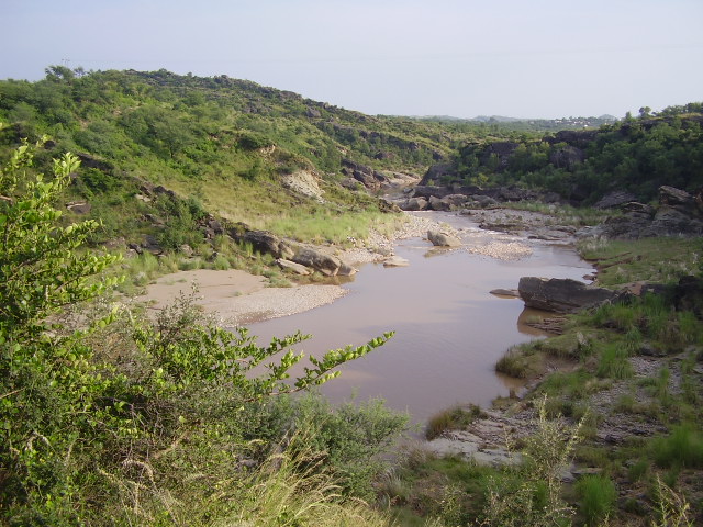


Overview
The Soan is generally described as more than 250 kilometres in length and runs across a predominantly undulating, rocky landscape. It collects runoff from a wide area of the Pothohar plateau, carrying variable flows that increase during the monsoon and after winter snowmelt in adjacent hills. The river ultimately joins the system that leads into the Indus near Kalabagh. Although occasionally referenced in older accounts alongside other districts, it lies within the Pothohar area and should not be conflated with geographically distant districts such as Bannu District.
Course and notable features
The Soan rises in the foothills near small settlements by Patriata Patriata and the Murree hills Murree. From its headwaters it flows through a sequence of ravines and open valleys. A number of smaller streams — for example the Ling stream and the Lai — join the Soan at different points, increasing its discharge seasonally. Near Sihala the Islamabad Highway crosses the watercourse and there are well-known local bridges and crossing points.
One of the most striking landscape features associated with the Soan is the deep gorge cut near Pharwala Fort Pharwala Fort. This narrow defile, often described as the river cutting through resistant uplands, is cited as an example of an antecedent or entrenched stream: the river maintained its course while surrounding terrain was uplifted, producing steep-walled sections sometimes called the "Swan Cut" in regional descriptions.
Uses, ecology and communities
Because the Soan has a relatively shallow bed and a largely seasonal flow pattern, its value for large-scale irrigation is limited. Local communities historically used water from its pools and tributaries for small-scale irrigation, livestock and domestic needs. Simblee Dam, a local reservoir supplied in part by the Soan's headwaters, provides stored water used for municipal supply to parts of the Islamabad area and for local water management Simblee Dam / Islamabad.
- Traditional water mills (grist mills) can still be found at a few locations such as Chakian where seasonal flow and local drops were harnessed for grinding grain.
- Fishing is generally limited and not a major commercial activity, though common riverine species like rohu (Rohu) occur where pools and stretches of deeper water persist.
- Birdlife, notably kingfishers (kingfisher) and other riparian species, use the river corridor as feeding and nesting habitat.
Geology, history and conservation
Geologically the Soan valley exposes sedimentary rocks and terraces that record phases of erosion and deposition across the plateau. Archeological and paleontological finds in the Pothohar region more broadly have shown occupation and land use around river terraces since prehistoric times, underlining the valley's long human importance. Modern pressures include urban expansion, extraction of sand and gravel, and seasonal pollution. Conservation and water management efforts focus on protecting recharge areas, maintaining reservoir quality and reducing contamination of the river's intermittent pools.
For readers seeking further background on regional geography, hydrology and local sites related to the Soan, consult regional sources and mapping resources that cover the Pothohar plateau and its network of streams and reservoirs (Punjab, Pakistan, Simblee Dam, Patriata, Murree, Pharwala Fort).
Related articles
Author
AlegsaOnline.com Soan River — a principal stream of the Pothohar Plateau Leandro Alegsa
URL: https://en.alegsaonline.com/art/91383