Line of Control (Kashmir) — de facto military boundary between India and Pakistan
The Line of Control (LoC) is the de facto military boundary dividing the Kashmir region between India and Pakistan, created after the 1947–49 conflict and formalized in agreements such as the 1972 Simla Agreement.
Overview
The Line of Control (often abbreviated LoC) is the effective frontline that separates the parts of the historic Kashmir region administered by the Republic of India and the Islamic Republic of Pakistan. It is not an internationally recognized political border but functions as a heavily militarized, practical dividing line along which control of territory, movement and security operations are conducted. The LoC runs for several hundred kilometres through mountainous terrain; commonly cited length is about 740 km and its approximate central coordinates are near 34.933°N 76.767°E.
Image gallery
6 Images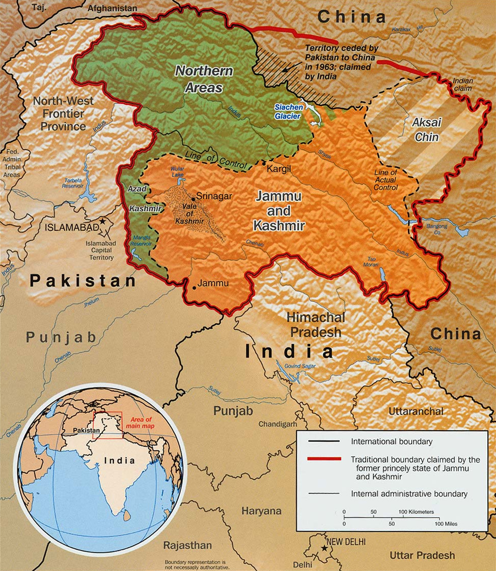


Characteristics and administration
On one side of the LoC are territories administered by India, traditionally known as the State of Jammu and Kashmir (and more recently reorganized into union territories). On the other side are the areas administered by Pakistan, commonly referred to as Azad Jammu and Kashmir and Gilgit–Baltistan. The route of the LoC follows positions established by opposing military forces when a ceasefire came into effect at the end of the first Indo–Pakistani war in 1948. It remains heavily guarded and is subject to strict cross-border controls, with fenced and patrolled sectors, observation posts and frequent military patrols.
History and legal status
The origins of the Line of Control date to the 1947–48 conflict that followed the partition of British India. Fighting created military fronts, and a UN-mediated ceasefire in early January 1949 froze those lines into a ceasefire line. Over time those military positions hardened into the present LoC. The name "Line of Control" was adopted after the 1972 Simla Agreement between India and Pakistan, which committed both sides to resolve differences bilaterally. Despite its practical permanence, the LoC is explicitly not a recognized international boundary; both countries and international observers describe it as a truce line or a de facto boundary rather than a final political border.
Implications, incidents and humanitarian impact
The presence of the LoC has shaped civilian life, security policies and regional diplomacy for decades. Periodic ceasefire violations, artillery exchanges and infiltration attempts have led to military and civilian casualties. Borderside communities have endured displacement, land loss and disruption of cross‑community ties. Multiple rounds of talks, confidence-building measures and ceasefire agreements have aimed at reducing violence, yet the LoC continues to be a focal point of tension between the two nuclear-armed states.
Related boundaries and distinctions
To the east, a separate disputed line divides Indian-controlled territory from areas controlled by the People's Republic of China in the high-altitude region of Aksai Chin; that frontier is commonly referred to as the Line of Actual Control (LAC). China and Pakistan have negotiated their own border agreements in areas where their administrations meet, but India does not accept some of those arrangements. Thus, Kashmir remains a triply contentious region in places where Indian, Pakistani and Chinese claims overlap or adjoin.
Further information and reference links
- Geographic coordinates and map references
- Overview of the Kashmir region
- India — administrative and security context
- Pakistan — administrative and security context
- Legal status and international law considerations
- Distinction from an international border
- Practical or de facto boundary status
- History of conflict in Kashmir
- Military frontlines and deployments
- 1949 ceasefire and UN involvement
- The former princely state of Jammu and Kashmir
- Gilgit–Baltistan and its governance
- Aksai Chin and China–India frontier
- Line of Actual Control (LAC) and its distinction
Questions and answers
Q: What are the coordinates of the Line of Control?
A: The coordinates of the Line of Control are 34°56′N 76°46′E / 34.933°N 76.767°E / 34.933; 76.767.
Q: Who controls each side of the Line of Control?
A: The land on one side of the line is controlled by India, and the land on the other side is controlled by Pakistan.
Q: When was a ceasefire declared between India and Pakistan over Kashmir?
A: A ceasefire was declared between India and Pakistan over Kashmir on 1/2 January 1949.
Q: What agreement was signed in 1972 regarding the Line of Control?
A: The Simla Agreement was signed in 1972, formally naming it as the Line of Control.
Q: What is all of Kashmir known as before it was divided?
A: All of Kashmir was previously known as the princely state of Kashmir and Jammu.
Q: What are two parts that are under Pakistani control called?
A: The two parts that are under Pakistani control are known as Gilgit-Baltistan and Azad Jammu and Kashmir (AJK).
Q: How long is the Line Of Control?
A: The Line Of Control is 740 km (460 mi) long.
Related articles
Author
AlegsaOnline.com Line of Control (Kashmir) — de facto military boundary between India and Pakistan Leandro Alegsa
URL: https://en.alegsaonline.com/art/58242
Sources
- news.indiainfo.com : "cross-border infiltration and terrorism"