
La Güera (Lagouira): ghost town at the southern tip of Western Sahara
La Güera (Lagouira) is a near-abandoned settlement on the Ras Nouadhibou peninsula, notable as the southernmost town of Western Sahara, with a complex colonial and postcolonial history and contested control.
Overview
La Güera, also written Lagouira or El Gouera and known in local languages as Tagwirt, is a largely abandoned coastal settlement at the southern extremity of what is internationally recognised as Western Sahara. Situated on the western flank of the Ras Nouadhibou peninsula, it faces the Atlantic Ocean and lies roughly 15 kilometres west of Nouadhibou. The place is commonly described as a ghost town because buildings are derelict, many streets are covered by drifting sand, and only a handful of fishermen and intermittent occupants remain.
Image gallery
5 Images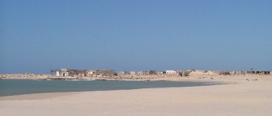


Geography and environment
La Güera occupies a narrow strip of coastal desert where the ocean meets winds that drive sand inland. Its position on the Atlantic coast makes it exposed to marine weather and to the encroachment of dunes that have buried parts of the settlement. The site is on the western side of the Ras Nouadhibou promontory, a geographic feature that divides coastal waters and has long shaped local fishing and maritime activity. The area’s environment is characterised by sparse vegetation, shifting sands and a reliance on small-scale coastal fishing for subsistence.
Origins and etymology
The town’s name derives from a Spanish term, reflecting the region’s period under Spanish colonial administration. In Spanish the root word refers to a channel or ditch used to channel water to fields, a meaning preserved in local explanations of the name; you can read about the Spanish influence in many historical accounts of the area. Local languages also have their own names for the place, reflecting Amazigh and Arabic heritage: the Berber form appears in regional usage and the Arabic name is commonly used in modern maps and reports.
History and decline
La Güera developed during the colonial era as a coastal outpost and changed character over the 20th century. After Spain’s withdrawal from the territory, the wider region became subject to competing claims and conflict. Over time the town was abandoned by formal garrison and administrative forces and fell into ruin; by the early 21st century much of it was already partially submerged beneath sand. Today only occasional inhabitants — including traditional Imraguen fishers who work the nearshore waters — occupy the ruins at intervals.
Political status and control
The settlement sits within a politically sensitive zone. It is claimed by both the Kingdom of Morocco and the Sahrawi Arab Democratic Republic, and it lies south of the Moroccan defensive berm or wall that separates different parts of the territory. Although neither Moroccan nor POLISARIO forces maintain a permanent presence in the abandoned town, the nearest authority on the peninsula has been Mauritanian forces, who at times have operated a military outpost near the site despite it not being formally incorporated into Mauritania. The name of the settlement is also used administratively by Sahrawi institutions in exile: there is a daira (an administrative unit) called La Güera in the Sahrawi refugee camps to the east.
Present-day significance and notable facts
La Güera is frequently cited in discussions of Western Sahara as an emblem of the territory’s unresolved status: a once-inhabited town reduced largely to ruins and sand. It remains part of the coastal fishing landscape, with local fishers and occasional visitors from nearby Nouadhibou using the shore. The place illustrates several wider themes: the legacy of Spanish colonial toponymy, the environmental impact of desertification and dune migration, and the geopolitical complexity of a territory claimed by multiple parties. For readers seeking background on the region’s geography and disputes, see materials on the Atlantic coast, the wider Western Sahara region, and the Ras Nouadhibou feature itself via local maps. Contemporary reporting also notes the presence of Mauritanian patrols and occasional security activity in the area (Mauritania, military), the shift of sand over buildings (sand), and the place’s contested claims by the Sahrawi Arab Democratic Republic as well as by Morocco. The town’s basic meaning in Spanish — a channel or ditch that brings water to crops — is often cited in etymological notes, while the colonial connection to Spain appears in historical summaries. For further contextual references and contemporary updates consult regional sources and humanitarian accounts that document the human and environmental dimensions of this littoral site.
- Location: Ras Nouadhibou peninsula, western side, Atlantic coast.
- Nearest city: Nouadhibou (approximately 15 km east).
- Current state: largely abandoned, occasional fishermen and guarded intermittently.
- Claims: contested by Moroccan authorities and the Sahrawi independence movement.
Related articles
Author
AlegsaOnline.com La Güera (Lagouira): ghost town at the southern tip of Western Sahara Leandro Alegsa
URL: https://en.alegsaonline.com/art/54991
Sources
- maroc-hebdo.press.ma : Guéguerre à Lagouira
- telquel-online.com : Enquête: Aux frontières du réel