Western Sahara
![]()
This article is about the territory of Western Sahara; for the state related to it, see Sahrawi Arab Democratic Republic.
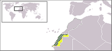
Western Sahara (Arabic الصحراء الغربية, DMG aṣ-Ṣaḥrāʾ al-Ġarbiyya, Central Atlas-Tamazight ⵜⴰⵏⴻⵥⵕⵓⴼⵜ ⵜⵓⵜⵔⵉⵎⵜ Taneẓṛuft Tutrimt; Spanish Sahara Occidental) is a territory on the Atlantic coast of northwestern Africa, claimed and mostly annexed by Morocco after the withdrawal of the former colonial power Spain in 1975. Morocco considers the area, which was in a loose dependent relationship with it in pre-colonial times, as part of its territory. It has a population of about 597,000, according to a 2019 estimate.
The left-wing "liberation front" of the Sahrawis (the population of Western Sahara), the Frente Polisario, which emerged during Spanish colonial times, is fighting for an independent state, the Sahrawi Arab Democratic Republic, on the entire territory of Western Sahara. Since the 1991 ceasefire, the Frente Polisario has controlled a strip in the east and south of Western Sahara from the border with Algeria to the Atlantic coast.
The United Nations is calling for a referendum to be held on the final status of the territory under international law. Morocco and the representatives of the Sahrawi people have so far been unable to reach agreement on the modalities for holding such a referendum. The main point of contention is the question of whether, in addition to integration or autonomy, independence of Western Sahara from Morocco should be an option in this referendum. Morocco rejected the latter as an option in 2004.

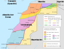
Depicted in six colors: Gradual securing of the Western Sahara occupation zone by Morocco in the 1980s. In addition, in light yellow: territory of the Polisario

Western Sahara is divided: the west is under Moroccan control, the far east and south under Polisario control. The map shows the situation before the end of the ceasefire in November 2020.
Geography
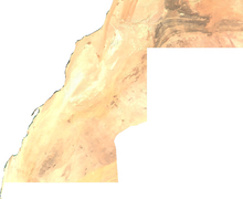
The territory of Western Sahara is located in northwest Africa on the coast of the Atlantic Ocean and covers an area of 266,000 km². It is geographically divided into a northern part, which in Spanish colonial times was roughly the province of Saguia el Hamra, and in which flat undulating gravel and scree deserts (hammada) predominate. The terrain rises gradually from the coast inland to an altitude of about 400 metres, with the highest elevations over 700 metres in the north near the Algerian border. The southern area corresponds roughly to the former province of Río de Oro and is almost completely flat with occasional sand dunes (erg), which provide little variety in the uniform, almost vegetationless Geröllebene. The third type of landscape are the dry river valleys (wadis), which carry water after the rainy season and of which the Saguia el Hamra is the most important for the oasis economy. It is the longest river in the country, stretching 350 kilometres to its end at Aaiún just before the Atlantic Ocean.

Satellite image of the topography of Western Sahara
Climate, flora and fauna
Desert climate prevails, rain is rare and fog is frequent near the coast. Lush vegetation is only found around the river oases and some gueltas. Animal species adapted to the dry habitat are found, for example desert jumping mice and thorn-tailed agamas. The largest populations of the Mediterranean monk seal, which is threatened with extinction, live in the caves on the Atlantic coast, especially on the Cabo Blanco peninsula.
Questions and Answers
Q: What is the name of the largest city in Western Sahara?
A: The largest city in Western Sahara is Laâyoune.
Q: What countries border Western Sahara?
A: The countries that border Western Sahara are Morocco to the north, Algeria to the east, Mauritania to the south, and the Atlantic Ocean to the west.
Q: How much of its surface area is desert flatlands?
A: Most of the territory of Western Sahara is made up of desert flatlands.
Q: How many people live in Western Sahara?
A: There are an estimated 500,000 people living in Western Sahara.
Q: Who claims control over Western Sahara?
A: Both Morocco and Polisario Front with its Sahrawi Arab Democratic Republic (SADR) government claim control over this territory.
Q: When did it become a Spanish colony?
A: In 1960s, when it was a Spanish Colony, it was listed by United Nations as one of non-self-governing territories.
Q: How has international recognition for both parties been changing over time?
A Polisario has won formal recognition for SADR from 81 states while Morocco has won recognition for its position from Arab League; however these recognitions have been extended and withdrawn according to changing international trends over past two decades.
Search within the encyclopedia