Interstate H-3 — Oʻahu's trans-Koolau freeway
Interstate H-3 is a 15.32-mile freeway on Oʻahu, Hawaii, linking the leeward corridor with the windward side via long viaducts and tunnels through the Koʻolau Range.
Interstate H-3 is a limited-access highway on the island of Oʻahu that carries the H-3 designation as part of the Interstate Highway System in the United States. It was built to provide a direct connection across the Koʻolau mountain range to the windward side of Hawaii island of Oʻahu and to improve access to military facilities. For official route data and maps see the route page at Interstate H-3 information.
Image gallery
5 Images


Route description
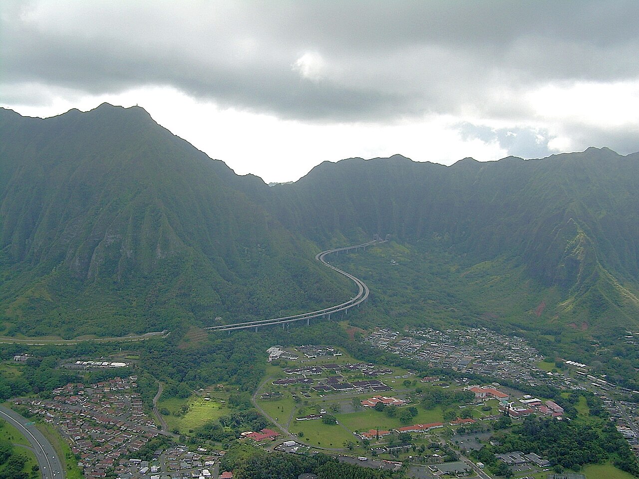
The freeway begins at the Halawa Interchange where it connects to Interstates H-1 and H-201, providing a link from the Honolulu metropolitan corridor to the new cross-island route (H-1 and H-201 connections). From there the pavement rises onto a long elevated viaduct that follows the floor of Halawa Valley. After several miles the highway enters the Tetsuo Harano Tunnels, bored through the main spine of the Koʻolau Range, and then descends along an engineered viaduct that contours the face of Haiku Valley.
Major interchanges and termini
On the windward side H-3 meets the Kaneohe Interchange with State Route 63 (Likelike Highway) and continues to the Halekou Interchange with State Route 83 (Kamehameha Highway). A short distance beyond these interchanges the freeway reaches the main gate of Marine Corps Base Hawaii on the Mokapu Peninsula. The entire route runs for about 15.32 miles (24.66 km) and serves both civilian and military travel needs.
Engineering and design features
H-3 is notable for its extensive high viaducts and for the Tetsuo Harano Tunnel complex. The highway was engineered to span sensitive valleys and steep slopes while reducing disturbance to the terrain; prominent elevated sections cross Halawa and Haiku valleys and required specialised foundations and bridged segments. The choice of long viaducts and tunnels was influenced by topography, drainage concerns and efforts to limit surface intrusion into culturally or environmentally important areas (viaduct design).
History, controversy and opening
Plans for a cross-island route date back decades, but construction of H-3 was delayed by legal challenges, environmental reviews, and concerns about cultural sites. These disputes, combined with engineering complexity, made the project one of the most contested highway builds in the state’s history. After prolonged work and mitigation measures, the freeway was completed and opened to traffic in the late 1990s. The line illustrates tensions that can arise when large infrastructure projects intersect with environmental protection and cultural preservation.
Importance and context
Today H-3 plays an important role in Oʻahu's transportation network by providing a relatively direct route between Honolulu's leeward communities and the windward towns such as Kaneohe, and by improving access to military installations. It also stands out as an example of modern roadway engineering on a volcanic island: a mix of tunnels, long-span viaducts and carefully sited interchanges intended to balance mobility, safety and site sensitivity. For background on the state highways that connect with H-3, see the pages for state transportation and local routes such as Kamehameha Highway and Kaneohe access.
- Length and endpoints: Halawa (H-1/H-201) to the windward side and Marine Corps Base access (route length).
- Key structures: Halawa and Haiku viaducts and the Tetsuo Harano Tunnel complex (engineering details).
- Significance: Civilian and military connectivity, notable construction history and environmental considerations (interchange map).
Further reading and official resources can be found through the highway and transportation pages linked above and at local planning offices that maintain records of the project's environmental review and construction history (state context, route data, base access notes).
Related articles
Author
AlegsaOnline.com Interstate H-3 — Oʻahu's trans-Koolau freeway Leandro Alegsa
URL: https://en.alegsaonline.com/art/47832