
Declination (astronomy): the celestial latitude coordinate
Declination (dec or δ) is the angular distance of a celestial object north or south of the celestial equator, forming one coordinate of the equatorial system paired with right ascension.
Overview
Declination, abbreviated dec or represented by the Greek letter δ, is one of the two spherical coordinates used in the equatorial coordinate system of astronomy. It describes how far north or south an object lies relative to the celestial equator, and together with right ascension specifies a fixed position on the sky for a given reference epoch. The concept is directly analogous to terrestrial latitude, projected outward onto the celestial sphere.
Image gallery
6 Images
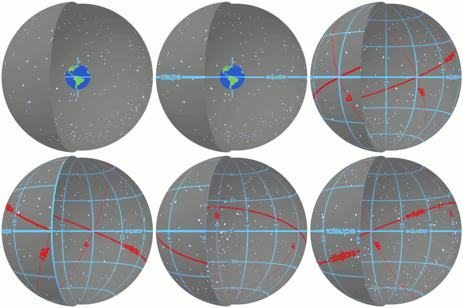



How declination is measured
Declination is measured in angular units: degrees (°), arcminutes (′) and arcseconds (″), or in modern practice often as decimal degrees. Values range from +90° at the north celestial pole, through 0° at the celestial equator, to −90° at the south celestial pole. Positive declinations indicate northern celestial hemisphere positions, negative declinations indicate southern positions. On star charts and catalogues, declination is normally paired with right ascension to yield a unique coordinate for each object.
Characteristics and notation
- Range: +90° to −90°; the north celestial pole has δ = +90°, the south pole δ = −90°.
- Units: degrees, arcminutes and arcseconds; sometimes listed in sexagesimal format similar to latitude.
- Circles of constant declination are parallel to the celestial equator; they shrink to points at the poles.
History and reference frames
The equatorial coordinate system and its use of declination have roots in ancient observational astronomy but were formalized with the development of spherical trigonometry and star catalogues. Because the Earth's axis slowly changes direction through precession and nutation, declination values measured at different times must be tied to a specific epoch and equinox (for example, modern catalogues commonly use epoch J2000.0). Proper motion of nearby stars and relativistic effects can also require corrections for precise astrometry.
Uses, examples and distinctions
Declination is fundamental for locating celestial objects, planning observations and converting between coordinate systems. For a given observer, declination helps determine whether an object is ever above the horizon and how high it will rise. Declination differs from altitude (the instantaneous height above a local horizon) and from other latitude-like coordinates such as ecliptic or galactic latitude, which use different fundamental planes. Practical tasks—pointing telescopes, creating star maps, and computing rise/set times—rely on declination together with right ascension and the observer's location.
Notable facts
Because lines of declination are defined with respect to the Earth’s axis, long-term changes in the orientation of that axis slowly shift the apparent declinations of objects. Catalogues therefore specify the reference epoch, and astronomical software commonly converts coordinates between epochs when comparing observations from different eras. For further introductory material, see general resources on astronomy or coordinate systems such as those explaining right ascension and the structure of the celestial sphere and the celestial equator.
Related articles
Author
AlegsaOnline.com Declination (astronomy): the celestial latitude coordinate Leandro Alegsa
URL: https://en.alegsaonline.com/art/26184