
Blue Earth River
The Blue Earth River is a 108-mile tributary of the Minnesota River in southern Minnesota and northern Iowa, known for its two branches, Dakota name, historical blue clay deposits, and agricultural watershed.
Overview
The Blue Earth River is a tributary of the Minnesota River that flows through southern Minnesota and northern Iowa in the United States. It has an overall length of about 108 miles (174 km) and contributes to the larger watershed that drains to the Mississippi River. The river system includes distinct headwaters and branches and passes through predominantly rural and agricultural landscapes.
Image gallery
4 Images
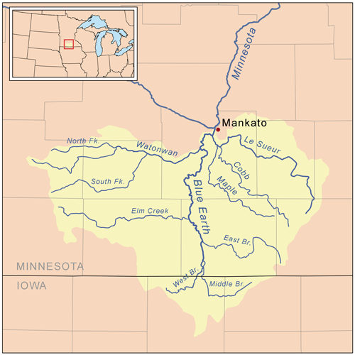


Course and tributaries
The Blue Earth River is formed by two principal headwater branches, commonly called the Middle Branch and the West Branch. These streams converge to form the main stem that eventually joins the Minnesota River. The river's channel and surrounding floodplain support a mix of wetland and upland habitats, and its flow regime is influenced by seasonal precipitation and runoff from cultivated fields.
History and name
The river takes its English name from historic deposits of bluish-green clay that were visible along some stretches of its banks. Early Indigenous inhabitants, the Dakota people, referred to the stream as Makato Osa Watapa, meaning "the river where blue earth is gathered." Those characteristic clay deposits are no longer widely visible today because of natural erosion, burial under sediments, and changes in land use.
Ecology, land use, and water quality
The Blue Earth River basin is largely agricultural, with corn, soybeans, and pasture dominating land cover across much of the watershed. As is common in such regions, agricultural runoff and soil erosion are key factors affecting water quality, contributing nutrients and sediment that can alter aquatic habitat and downstream water conditions. Riparian vegetation, wetlands, and targeted conservation practices can help mitigate these impacts and support fish and wildlife populations.
Uses and recreation
Local residents and visitors use sections of the Blue Earth River for recreation such as boating, fishing, and wildlife observation. River corridors also provide scenic and ecological value in an otherwise farmed landscape. Several communities and landowners manage access points and small parks along the river to support outdoor activities and river stewardship.
Conservation, management, and notable facts
Efforts to protect and improve the Blue Earth River focus on reducing sediment and nutrient loads, restoring riparian buffers, and enhancing wetland functions to retain runoff. The river is part of the larger Mississippi River basin network, highlighting how changes in a local tributary can affect downstream rivers and estuaries. For regional information and management guidance, see local watershed organizations and state resources, which provide maps, data, and programs related to the watershed and river basin. Additional background on tributaries and regional hydrology is available through resources that discuss the Blue Earth River as a tributary of the Minnesota River and its place within the Mississippi River system. Historical and cultural context, including the Dakota name Makato Osa Watapa and the story of the blue clay, is summarized in regional histories and local repositories of Indigenous place names. For more general geological context about clay and soils, consult resources on clay deposits and sedimentary processes. Educational and governmental sites often offer further maps and recreational guidance at state and local levels (Minnesota, Iowa, and national U.S. agencies).
- Length: ~108 miles (174 km)
- Headwaters: Middle Branch and West Branch
- Drainage: part of the Mississippi River basin via the Minnesota River
- Traditional Dakota name: Makato Osa Watapa
Related articles
Author
AlegsaOnline.com Blue Earth River Leandro Alegsa
URL: https://en.alegsaonline.com/art/12340
Sources
- geonames.usgs.gov : "Geographic Names Information System entry for Middle Branch Blue Earth River (Feature ID #459026)"
- geonames.usgs.gov : "Geographic Names Information System entry for West Branch Blue Earth River (Feature ID #653931)"
- geonames.usgs.gov : "Geographic Names Information System entry for Blue Earth River (Feature ID #640285)"
- iaspub.epa.gov : "National Assessment Database: Assessment Data for the State of Minnesota Year 2004"
- iaspub.epa.gov : Blue Earth Watershed
- pca.state.mn.us : "Watersheds of the Minnesota River Basin"
- pca.state.mn.us : Minnesota River Basin: Blue Earth, Watonwan, and Le Sueur River Watersheds
- pubs.usgs.gov : "Water Resources Data in Minnesota, Water Year 2005 Annual Report"
- pubs.usgs.gov : Blue Earth River near Rapidan, MN