Blue Lake (Mount Gambier, South Australia)
A volcanic crater lake in Mount Gambier noted for its seasonal colour change, volcanic origins, notable depth, unique benthic life and role as a managed drinking water supply and tourist landmark.
Overview
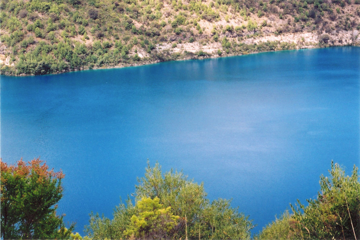
The Blue Lake sits within the Mount Gambier volcanic complex in southeastern South Australia. Known to the local Bunganditj (Boandik) people as Warwar, the lake occupies a broad maar-style crater and is the most prominent of Mount Gambier's four crater lakes. It is an important municipal water source and a major scenic landmark: each year its striking seasonal change in colour attracts many visitors to the town while the rim and surrounding parkland provide walking tracks and lookouts.
Image gallery
7 Images


Geology and age
The lake occupies a phreatomagmatic crater formed by explosive interaction between magma and groundwater. Estimates for the timing of the last eruptive activity at Mount Gambier vary; studies have produced ages ranging from several thousand to many tens of thousands of years. If the youngest proposed ages are correct, the Mount Gambier vents would represent some of the most recent volcanic activity on the Australian mainland. For general background on crater types see volcanic crater summaries and for broader regional context consult material on Australian mainland volcanism.
Dimensions, hydrology and use
The Blue Lake is relatively deep for a crater lake, with an average depth reported near 72 metres and maximum depths around 77 metres in places. The crater rim measures roughly 1,200 by 824 metres while the water surface and basin measure approximately 1,087 by 657 metres. The lake lies below the level of the town centre and has long been managed as a potable drinking water source for Mount Gambier. Over recent decades the regional groundwater table has experienced fluctuation and localized decline, prompting attention to catchment protection and supply management; see materials on water table issues for general context.
Seasonal colour change
Blue Lake is renowned for a pronounced seasonal colour shift. In late spring and summer the lake develops an intense bright blue appearance, while in autumn and winter it tends toward greyer or steely tones. This transformation is commonly attributed to seasonal stratification and changes in water temperature that alter the distribution of suspended particles and the degree of calcite precipitation, together with variations in light scattering. These physical and chemical processes interact with the lake's clarity to create the dramatic visual effect observed from the rim.
Biology, sediments and underwater features
Scientific and recreational diving has revealed a biologically and geologically interesting lake bed. Major exploration began in the 1980s; cave diver Peter Horne and others measured temperature and visibility profiles and recorded benthic life. Divers reported the discovery of a freshwater sponge species and a variety of invertebrates adapted to the deep, clear water. Portions of the lake bed are covered in calcite-rich silt and carbonate deposits, and a northeast area at depth has been described as containing hollow, layered structures often referred to in publications as a stromatolite-like field. These features and the sediment cores recovered in later dives have been used to interpret past environmental conditions and sedimentation processes. For topics related to the organisms and deposits see entries on freshwater sponge, aquatic invertebrates, stromatolites and calcite.
Research, exploration and monitoring
Underwater exploration in the 1980s established baseline observations; more recent diving and coring campaigns have recovered sediment records and measured bottom-water temperatures (one report measured about 14 °C at the lake bed). These data assist in reconstructing environmental change and in managing the site. The lake is monitored for water quality because it supplies the town, and management aims to balance protection of the catchment with public access to viewpoints and interpretive facilities.
Access, heritage and conservation
The rim park is developed with designated walking paths, lookouts and interpretive signage that explain the lake's natural and cultural significance. Direct access to the water is restricted because of its role as a water supply and to protect sensitive habitats and sediments. Conservation concerns include changes in groundwater levels, land-use pressure around the catchment and the need to protect archaeological and Indigenous values of the landscape. Local authorities and traditional owners cooperate in managing the area to conserve both natural and cultural heritage.
Notable facts
- One of four crater lakes at Mount Gambier and the most visited natural attraction in the locality.
- Famous for a strong seasonal colour change linked to physical, chemical and biological processes.
- Contains distinctive benthic communities and carbonate sediment features that have attracted scientific diving and sediment coring.
- Its eruptive age remains the subject of research; some studies suggest comparatively recent Holocene activity while others favour older dates.
For site-specific or technical information consult local geological surveys and water authorities. Additional general references and background topics are available via resources on volcanic craters, groundwater, regional volcanism, drinking water supplies, and literature on freshwater sponges, aquatic invertebrates, stromatolites and calcite sediments.
Questions and answers
Q: Where is the Blue Lake?
A: The Blue Lake is in Mount Gambier, South Australia.
Q: What type of formation is the Blue Lake?
A: The Blue Lake may be a dormant volcanic crater.
Q: How many crater lakes are there on Mount Gambier?
A: There are four crater lakes on Mount Gambier.
Q: Why does the Blue Lake change color?
A: The Blue Lake changes color from grey to bright blue due to changes in water table.
Q: When was the most recent volcanic eruption on the Australian mainland?
A: If the youngest date is correct, the most recent volcanic eruption on the Australian mainland was a little before 6000 years ago.
Q: What is the average depth of the Blue Lake?
A: The average depth of the Blue Lake is 72 meters but reaches 77 meters in some places.
Q: What has been discovered in the Blue Lake during diving exploration?
A: In the Blue Lake, diving exploration has discovered a fresh water sponge species, other invertebrates, and "The stromatolite field," hollow rock formations on the north-eastern edge at a depth of 40 meters. In 2008, core samples from the calcite-silt covered lake bed were brought up, and the water temperature on the lake bed was measured at 14 degrees Celsius (57 °F).
Related articles
Author
AlegsaOnline.com Blue Lake (Mount Gambier, South Australia) Leandro Alegsa
URL: https://en.alegsaonline.com/art/12351