Mississippi River — course, history, uses, and environmental issues
A comprehensive overview of the Mississippi River: its course, tributaries, human uses, ecology, historical role, and modern challenges including nutrient runoff and flood control.

Overview
The Mississippi River is a major waterway of the North American interior and a defining feature of the United States. Rising in northern Minnesota and flowing generally south to the Gulf of Mexico, it is one of the longest rivers in the world and drains a substantial portion of the continent. The river’s name derives from a Native American language term meaning "great river." Major urban centers on its banks include Memphis, New Orleans and others that historically and today rely on the river for commerce and transport.
Image gallery
10 Images


Course and watershed
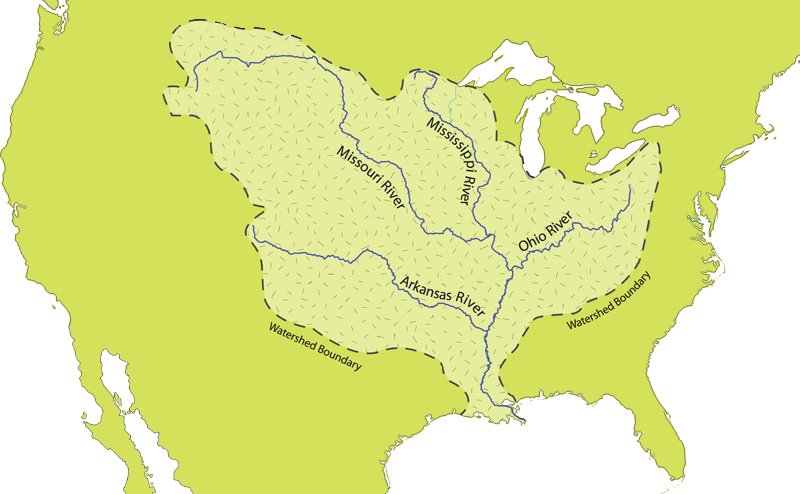
The conventional headwaters of the Mississippi are at Lake Itasca in Minnesota, not far from the border with Canada. From there the river flows south through or along the borders of many states, including Wisconsin, Iowa, Illinois, Missouri, Kentucky, Tennessee, Arkansas, and Mississippi, finally reaching the coast in Louisiana near New Orleans. Its watershed collects water from numerous tributaries (notably the Missouri and Ohio rivers) and covers a vast area of the central United States, making the Mississippi system crucial to regional hydrology, agriculture and industry.
Human uses and engineering
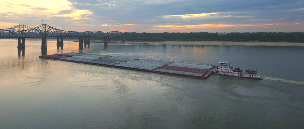
The river supports extensive inland navigation: barges carry bulk commodities such as grain, coal and petroleum along its channel to ports and refineries. To maintain reliable navigation and manage floods, the river has been altered with levees, locks and dams, dredging and channel stabilization—projects largely undertaken by federal agencies. These interventions facilitate commerce but also change natural flow patterns and habitats.
Ecology and environmental challenges
The Mississippi and its tributaries sustain diverse freshwater ecosystems and provide critical habitat for fish, birds and other wildlife. However, runoff from agriculture and urban areas carries nutrients, sediments and chemicals downstream. Excess nitrogen and phosphorus—often from synthetic fertilizers—promote algal blooms and contribute to a seasonal low-oxygen "dead zone" in the Gulf of Mexico, where reduced oxygen levels stress marine life and fisheries. Addressing these impacts requires coordinated watershed-scale practices such as improved nutrient management, wetland restoration and conservation tillage.
History, culture and notable facts
The river played a central role in North American exploration, trade and settlement. It served as a transportation corridor for Native peoples and later European and American explorers, traders and settlers. The Mississippi features prominently in American literature, music and folklore—most famously in the writings of 19th-century authors who used its landscapes and river life as themes. Historically and today, towns and cities along the river have grown as ports and cultural centers.
Key features and examples
- Source: Lake Itasca (Minnesota).
- Mouth: Gulf of Mexico via a delta in Louisiana.
- Principal tributaries include the Missouri and Ohio rivers; many states are in the basin, from Wisconsin to Mississippi.
- Major cities on the river: Memphis, St. Louis, Baton Rouge and New Orleans.
The Mississippi remains both an engine of commerce and a complex ecological system. Its future depends on balancing human uses with conservation measures that reduce pollution, restore wetlands and allow more natural river processes to function alongside engineered infrastructure.
Etymology
The name Mississippi probably comes from the language of the Algonkin Indians. It is composed of the words messe for great and sepe for water. The frequently encountered translation "father of waters" is more a poetic than a literal translation. Another possible origin would be from the Anishinabe language Messipi for "great river". Colloquially, the Mississippi River is often called "Old Man River" in the United States, immortalized most notably in the song Ol' Man River from the 1927 musical Show Boat.
Geography
Catchment area and river system
The Mississippi drains most of the part of the United States of America located between the fringe mountains in the east (Appalachians) and in the west (Rocky Mountains) into the Gulf of Mexico. The Mississippi River basin is the fourth largest in the world. It covers 3,220,000 square kilometres and extends over 31 states of the USA and two provinces of Canada. Due to its predominant location in the west wind belt, the western part, which lies in the lee of the high mountain ranges, is predominantly semi-arid and the eastern part humid.
The main named branch of the stream system runs approximately south-central and originates west of Lake Superior in headwater streams that feed Lake Itasca, which is considered the source of the Mississippi River. It reflects the hygric differences of the drainage basin that the actual main branch of the Mississippi River system (determined by the larger confluent water body in each case) originates in the precipitation-rich Appalachian Mountains, whereas the longest branch of the river system originates in the Rocky Mountains. The main hydrologic branch is formed by the Allegheny River-Ohio-Mississippi flow path. The longest flow path follows the line Red Rock River - Beaverhead River - Jefferson River - Missouri - Mississippi.
The most important tributaries of the Mississippi
Left tributaries
- St. Croix River
- Black River
- Wisconsin River
- Rock River
- Illinois River
- Kaskaskia River
- Ohio
- Hatchie River
- Yazoo River
- Big Black River
Right tributaries
- Minnesota River
- Root River
- Cannon River
- Turkey River
- Iowa River
- Des Moines River
- Skunk River
- Salt River
- Missouri
- Saint Francis River
- White River
- Arkansas
- Red River
Runoff data
At the confluence with the Missouri, the Mississippi River carries slightly more water on average at about 2900 m³/s than its much longer tributary, which contributes about 2200 m³/s. The Upper Mississippi then meets the Ohio with a mean flow of around 5900 m³/s, which carries more water at around 7950 m³/s and is hydrographically the main stem of the river system.
The figures for the mouth of the Mississippi differ considerably, also because the Atchafalaya branching off about 500 km above the mouth is sometimes not included. Here, up to 30 % of the mean discharge branches off from the main stream and shortly afterwards takes up the Red River, which with a water flow of 1590 m³/s is only a tributary of the larger Atchafalaya with a mean discharge of 4730 m³/s and thus also a tributary of the Mississippi. The total value of about 18 400 m³/s, which is mostly given and includes the Atchafalaya with Red River, is thus hydrographically justified and characterizes the river system better than the flow of the main stream alone, for whose estuary values of about 16 800 m³/s are given. This puts the Mississippi in seventh place among the world's rivers flowing into the sea, although it is also surpassed by three tributaries of the Amazon.
River sections
The Mississippi River can be generally divided into its headwaters (Upper Mississippi River), from its source to the confluence with the Ohio, and its lower reaches (Lower Mississippi River), from the Ohio to its mouth in the Gulf of Mexico.
headwater of the Mississippi
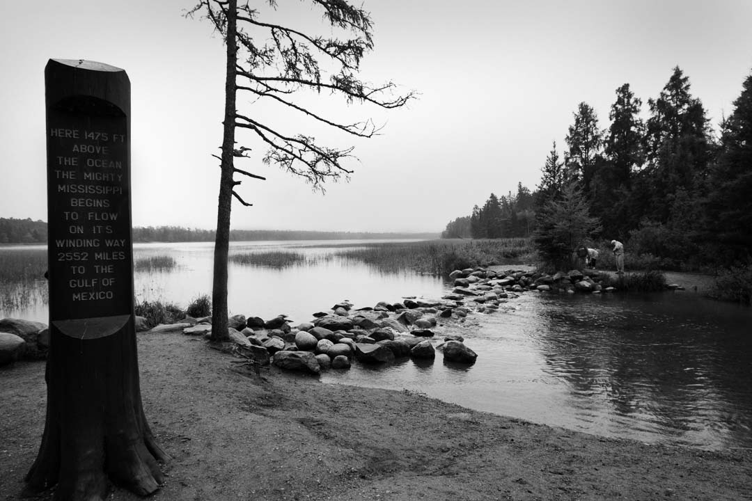
The source of the Mississippi River is located at 47° 11' north latitude and 95° 14' west longitude in northern Minnesota in Itasca State Park. Lake Itasca collects several headwater streams at 450 meters above sea level, the largest of which drains nearby Elk Lake, and discharges the Mississippi River as a five-meter-wide stream. The source of the largest Itasca Lake tributary near Little Elk Lake a few miles to the south is considered the actual source of the Mississippi River.
Downstream, the Mississippi River meanders strongly through the glacially formed lake district in northern Minnesota. It crosses numerous lakes, the largest being Lake Winnibigoshish. Below Coon Rapids Dam near Minneapolis, the Mississippi is navigable. Until its completion in 1913, the river was navigable by ships even as far as St. Cloud.
Saint Anthony Falls in Minneapolis and a few smaller falls at Little Falls in Minnesota were the only natural waterfalls on the upper reaches of the Mississippi. Today, the upper reaches between Minneapolis and St. Louis are marked by a succession of 29 dam and lock structures, built until the 1940s, and used by navigation to overcome 123 meters of elevation. They were built to facilitate the transport of bulk cargo from the northern United States to the Gulf of Mexico. The dams also allow the flow of the upper river to be regulated, thus affecting that of the lower river. Critics question the economic benefits of the structures and complain about their negative ecological impact. The dam and lock structures are maintained by the United States Army Corps of Engineers.
The reservoirs, some of which are lake-like, are now also used for tourism. Along the Mississippi River in the border area of the states of Minnesota, Wisconsin and Iowa, two protected areas have been designated to preserve the river and its surroundings as a habitat, the Mississippi National River and Recreation Area and the Effigy Mounds National Monument. The nutrient-rich bluffs on both banks are also a wine-growing area.
North of St. Louis, the Mississippi joins the Missouri to form a wide river. As the largest tributary, even surpassing the Mississippi in water flow, the Ohio finally flows into the river at Cairo. The most important tributaries of the upper course are the Minnesota River, Iowa River, Des Moines River, Illinois River, Missouri and Ohio.
lower reaches of the Mississippi
South of the confluence with the Ohio, the Mississippi enters an inland bay about 80 km wide. Due to the low relief energy and the small elevation difference (96 m) from Cairo to the mouth into the Gulf of Mexico, the Mississippi forms wide meanders in its lower course. Dynamic changes in the riverbed over the centuries and river straightening measures have created extensive floodplain landscapes on both riverbanks through separated oxbow lakes.
Since the borders of the US states in this region are based on a historical course of the river, the shifting of the riverbed has meant that the Mississippi nowadays no longer represents a continuous natural border between different states. For example, the state of Arkansas has exclaves on the left bank, while parts of the right bank now belong to the states of Tennessee and Mississippi.
In the south of the state of Louisiana, the river flows into the Gulf of Mexico in an extensive delta. The longest estuary branch is the Atchafalaya River, which branches off from the Mississippi about 500 km before the main mouth and itself forms a delta. The United States Army Corps of Engineers Old River Control Structure limits the amount of water that can flow from the main branch of the river into the Atchafalaya to about 30%, and nearly 50% in flood conditions. Downstream of New Orleans, a finger-shaped, so-called bird's-foot delta has formed over time due to the large sediment load of the river and the low tidal range of the Gulf of Mexico, which has five main branches. At 28,600 km², it is one of the largest estuarine deltas in the world. The amount of delivered river freight in the Mississippi Delta is 1 to 1.5 million tons of sediment daily. The shallow alluvium created by regular flooding is very fertile. The influx of nutrient-rich freshwater and the salty ocean water that flows in at alternating tides result in high rates of primary production (algae, phytoplankton) and increasing proportions of soil organic matter. The high biodiversity in the waters favours fisheries. It yields about one million tons of fish per year, making it the most important in the United States. The main agricultural crops are rice, cotton, sugar cane and soybeans. The two main problems in the Mississippi Delta area are the loss of wetlands due to sea level rise and eutrophication.
Numerous hydraulic engineering measures have been carried out in the Delta over the last century to facilitate navigation to the refinery sites in Louisiana. These include straightening the course of the river, constructing dikes for flood protection, deepening the navigation channel by removing sandbanks, and connecting the river to the canal network of the Intracoastal Waterway.
Major tributaries of the lower river include the White River, Arkansas, Yazoo River, and Red River. The region along the lower reaches of the river is also called the Lower Mississippi Delta Region; it stretches from southern Illinois and Missouri on both sides of the river to the mouth and has many cultural and social similarities.


Questions and answers
Q: Where does the Mississippi River originate?
A: The source of the Mississippi is Lake Itasca in Minnesota, near the border with Canada.
Q: What is the meaning of "Mississippi"?
A: The name "Mississippi" comes from a Native American name that means "big river".
Q: How many states does the Mississippi River flow through?
A: The Mississippi flows south through the middle of the United States and flows through the states of Minnesota, Wisconsin, Iowa, Illinois, Missouri, Kentucky, Tennessee, Arkansas, and Mississippi.
Q: Where does the Mississippi River end?
A: The mouth of the Mississippi is in Louisiana south of New Orleans. It then flows into Gulf of Mexico.
Q: What effect do chemicals from farms have on animals at the end of the river?
A: At the end of the river there is a zone in Gulf of Mexico where very few animals can survive comfortably because fertilizer and other chemicals run off farms into river and its tributaries which are then carried into gulf.
Q: What is largest city located on or near to this river?
A: The largest city located on or near to this river is Memphis Tennessee.
Related articles
Author
AlegsaOnline.com Mississippi River — course, history, uses, and environmental issues Leandro Alegsa
URL: https://en.alegsaonline.com/art/65489
Sources
- decolonialatlas.wordpress.com : "The Headwaters of the Mississippi River in Ojibwe"
- zia.aisri.indiana.edu : "AISRI Dictionary Database Search"
- myaamiadictionary.org : "Myaamia Dictionary Search"
- cdkc.edu : "English – Cheyenne"
- ou.edu : "English – Kiowa"
- colorado.edu : "XML File of Arapaho Place Names"
- zia.aisri.indiana.edu : "Southband Pawnee Dictionary"
- pubs.usgs.gov : USGS.gov
- fwp.mt.gov : MT.gov
- toxics.usgs.gov : Hypoxic zone-USGS