Minnesota: geography, history, culture and economy
Overview of Minnesota in the Upper Midwest of the United States: geography, climate, Indigenous heritage, Twin Cities, economy, recreation and notable facts, including statehood and political history.
Minnesota is a U.S. state located in the Upper Midwest of the United States. It occupies a northern position on the continent and shares an international boundary with Canada. The state's landscape includes prairie in the southwest, mixed forests and lakes across the central and northern regions, and river valleys that helped shape its settlement and development.
Image gallery
10 Images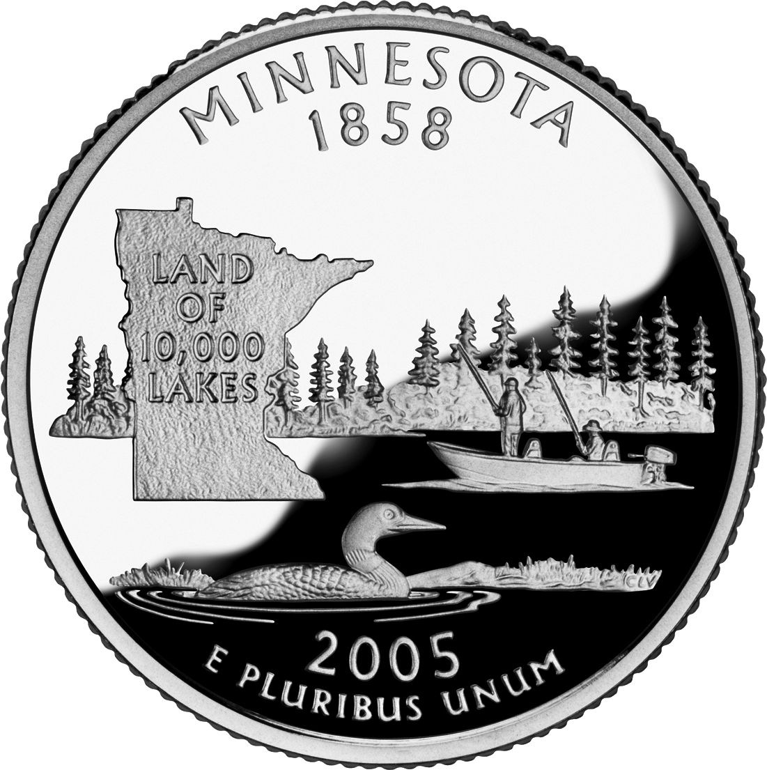


Cities and population
The state capital is Saint Paul, while the largest city in population is often identified with the neighboring Minneapolis. Together these two cities and their suburbs form the metropolitan area commonly called the Twin Cities; more than three million people live in that metro region. The Twin Cities are divided geographically by the Mississippi River and serve as hubs for commerce, culture, education and transportation.
Origins, statehood and Indigenous peoples
Minnesota became the 32nd state of the United States on May 11, 1858. Its name comes from a Dakota word meaning "sky-tinted water," reflecting the importance of lakes and rivers to the region. Indigenous nations such as the Dakota and Ojibwe (also called Chippewa) have long histories in the area; references to Indigenous languages and cultures remain central to place names and traditions in the state (Dakota).
Climate and natural features
Most of Minnesota lies within a humid continental climate zone: winters are cold and often snowy, while summers are warm to hot depending on latitude. The state slogan "Land of 10,000 Lakes" points to its abundance of inland water, which supports fishing, boating and a robust outdoor recreation economy. Northern forests, wetlands and the unique Boundary Waters canoe country are especially important for conservation and tourism.
Economy, culture, and recreation
Minnesota's economy is diverse, combining agriculture (including corn and soybean production), manufacturing, healthcare, education, and a growing technology and services sector. Arts institutions, seasonal festivals, and a strong tradition of civic engagement contribute to a distinctive cultural life. Outdoor activities — canoeing, ice fishing, snow sports and hiking — attract residents and visitors year-round.
Notable facts and politics
Beyond its natural attractions, Minnesota has played interesting roles in American politics: for example it was the only state to vote for Walter Mondale in the 1984 election when he carried the state while losing nationwide to Ronald Reagan. The Twin Cities area is an economic and cultural engine, and the state's mixture of urban centers, small towns and extensive wilderness makes it regionally significant within the Upper Midwest and the broader nation.
- Capital: Saint Paul
- Largest city: largest city — Minneapolis
- Major river: Mississippi River
- Indigenous language reference: Dakota
- Climate type: humid continental
- Historic election note: 1984 election, Walter Mondale
Geography
Minnesota is the northernmost state in the U.S. after Alaska; the so-called Northwest Angle is the only part of the 48 contiguous states that extends northward beyond the 49th parallel. The northeastern part of the state lies on the shore of Lake Superior and shares lake borders with the Canadian province of Ontario and the states of Michigan and Wisconsin. Bordering Minnesota to the east and southeast is Wisconsin, Iowa to the south, North and South Dakota to the west, and the Canadian provinces of Ontario and Manitoba to the north. At 225,171 square kilometers (about 2.25 percent of the total area), Minnesota is the twelfth largest state in the United States and the second largest in the Midwest. The extension in north-south direction is about 660 kilometers, in east-west direction about 560 kilometers.
Geology and landscape
Minnesota is home to some of the oldest rocks on Earth, with some gneisses as old as 3.6 billion years. About two billion years ago, lava was able to escape through cracks in the primordial ocean. The remaining pieces of volcanic rock formed the Canadian Shield in northeastern Minnesota. After volcanic activity continued until 1.1 billion years ago, geologic activity was relatively low. Volcanism, mountain building, and earthquake activity have occurred on an extremely small scale since then.
The foothills of the volcanic mountains formed lakes in northern Minnesota during the Precambrian. These lakes caused a flattening of Minnesota that intensified with the glaciation that began 600,000 years ago. Glaciers at least a mile thick moved across the areas and shaped Minnesota's present landscape. The last of four significant glaciers, the Wisconsin Glacier, retreated from Minnesota 12,000 years ago. The extent of these glaciers ranged across all of Minnesota except the outer southwest and southeast.
The glaciers left a bedload layer of usually at least 50 feet across the state. When the last glaciers had retreated, the huge Lake Agassiz formed in the northwest; the path flow of this lake formed the course of the Minnesota River, and the bottom of the lake became the fertile land of the Red River Valley. Nowadays, geological activity in Minnesota is low. Earthquakes occur irregularly, but they are usually weak. The strongest earthquake of the last century occurred near Morris in 1975 and was measured at 4.6 to 4.8 magnitudes on the Richter scale.
The highest point in the state is Eagle Mountain at 701 metres, which is only about 21 kilometres from the lowest point on the shore of Lake Superior at 183 metres. Precipitation can drain into the Gulf of Mexico via the Mississippi River, into the Atlantic Ocean via the St. Lawrence Seaway, or into the Arctic Ocean via Hudson Bay.
The state's nickname, Land of 10,000 Lakes, is no exaggeration. Minnesota is home to 11,842 lakes covering over four hectares. Lake Superior has the largest water surface area at just under 3900 square kilometers and about 393 meters of water depth in the state. Minnesota has 6564 rivers with a total length of about 110,000 kilometers. The Mississippi River begins at Lake Itasca and crosses the border with Iowa after almost 1090 kilometers downstream. It is joined by the Minnesota River at Fort Snelling, the St. Croix River at Hastings, the Chippewa River at Wabasha, and many other small streams in the southeast. By way of the Red River, on what was once the bottom of Lake Agassiz, the waters of the northwestern part of the state flow northward into Hudson Bay, Canada.
Protected areas
Minnesota has 66 state parks, 57 state forests covering approximately 16,000 square miles, and numerous nature preserves. The first state park, Itasca State Park, was established in 1891. The two national forests, Chippewa National Forest and Superior National Forest, cover an area of 22,200 km². In Superior National Forest, on the northeastern border of the state, is the Boundary Waters Canoe Area Wilderness, which covers over 4000 km² and a thousand lakes. Voyageurs National Park is the only national park in the state. There are also two National Monuments: Pipestone National Monument preserves the quarries where Plains Indians quarried and still quarry the stone for their pipes, and Grand Portage National Monument is a memorial to the history of the fur trade at the site of a trading post on Lake Superior.
flora and fauna
Minnesota's vegetation is largely typical of North America: prairie grasslands in the western and southwestern parts of the state, deciduous forest in the southeast, and the northern boreal forests. The northern coniferous forests are extensive areas covered by pine and spruce with occasional birch and cottonwood. Large areas of Minnesota's northern forest have been logged. Only a few areas, such as in the Chippewa National Forest and the Superior National Forest, which contains 1620 square miles of uncleared forest, remain originally vegetated. With regrowth, the state's forest cover is back to about one-third.
Although wildlife destruction has caused many native animals such as spruce martens, wapitis, buffalo, cougar, reindeer, and bobcats to lose large portions of their habitat, numerous other native species are thriving. Minnesota has the second largest wolf population in the U.S. after Alaska and has healthy black bear, moose and white-tailed deer populations. Along the Mississippi Flyway, the state is home to migratory waterfowl such as geese and ducks, as well as game birds such as grouse, pheasants, and turkeys. In addition, Minnesota is home to birds of prey such as the bald eagle, red-tailed hawk, and snowy owl. The lakes are home to numerous glass-eyed bass, striped bass, muskellunge, and European pike. The rivers in the southeast are populated by brook trout, brown trout and rainbow trout.
Climate
→ Main article: Minnesota climate
Minnesota has a continental climate. Thus, the winters are rather polar with temperatures far below zero degrees Celsius, Minnesota is considered the coldest state after Alaska. Summers, on the other hand, are hot and humid, especially in the south of the state. Cold snaps and blizzards can occur throughout the winter. The annual average temperature is two to eight degrees Celsius. According to the Köppen/Geiger climate classification, the southern part of the state falls into the humid continental climate with hot summers (Dfa), the northern two-thirds are assigned to the humid continental climate with warm summers (Dfb).
The regions in the northeast are also influenced by the balancing effect of Lake Superior. This means that temperatures in winter are comparatively moderate for the region, while the lake has a cooling effect in summer.
Depending on location, annual precipitation ranges from about 480 mm in the northwest to 860 mm in the southeast, and droughts occur about every ten to 50 years. The growing season varies from 90 days in the Iron Range to 160 days in southeastern Minnesota near the Mississippi River. Southern Minnesota is part of the Tornado Alley area.
| Average temperatures in Minnesota in (°C) | ||||||||||||
| Jan | Feb | Mar | Apr | May | Jun | Jul | Aug | Sep | Oct | Nov | Dec | |
| −13 | −9 | −4 | 4 | 11 | 16 | 19 | 18 | 13 | 7 | −2 | −10 | |
| International Falls | −16 | −12 | −4 | 4 | 12 | 17 | 19 | 18 | 12 | 6 | −4 | −13 |
| −11 | −8 | −1 | 7 | 14 | 19 | 21 | 20 | 15 | 8 | −1 | −8 | |
| Twin Cities | −11 | −7 | 0 | 8 | 15 | 20 | 23 | 22 | 16 | 9 | 0 | −7 |
Structure
Minnesota is divided into 87 counties.
→ Main article: List of counties in Minnesota


History
Aboriginal and discovery
Before European settlement, Minnesota was populated by the Anishinabe, Sioux, and other Native Americans. In the southwestern part of the state are the quarries where catlinite, the pipe stone, was and is quarried. It was traded throughout the Great Plains and all the Plains Indians favored it to carve the heads of their peace pipes (calumets) from.
The first European settlers were French fur traders who arrived in the early 17th century. Later, as the Ojibwe Indians moved further west into Minnesota, tensions arose with the Sioux. Explorers such as Daniel Greysolon, Sieur du Lhut, Louis Hennepin, Jonathan Carver, Henry Schoolcraft, and Joseph Nicollet conducted explorations and mapped the area of what is now the state of Minnesota. In 1679, after an expedition, Greysolon established a fort on the shores of Lake Superior and henceforth claimed the area of northern Minnesota for France.
However, as a result of the French and Indian War, France had to cede these territories to Great Britain in 1763. With the Peace of Paris and the Declaration of Independence, the area between the Great Lakes and the Mississippi became part of the Northwest Territory and thus belonged to the USA for the first time. Nevertheless, the region remained heavily influenced by Great Britain until about 1816. With the Louisiana Purchase, the U.S. also acquired the southern and western territories of what is now Minnesota from France. Between 1860 and 1870 came the first large wave of German immigrants, who still shape Minnesota's cultural image today.
Beginning of statehood
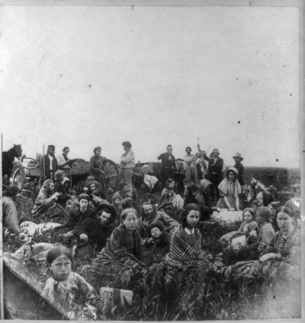
In 1805, explorer and officer Zebulon Pike acquired lands at the confluence of the Minnesota River and the Mississippi River. However, it was several years before the first settlers arrived in the area. As a result, Fort Snelling was built as the first permanent settlement from 1819 to 1825. In addition, soldiers built a water mill and a sawmill at Saint Anthony Falls. As industry later grew, the city of Minneapolis formed there. In the meantime, many people had settled near the fort. In 1839, the army forced them to move downriver and they settled in the area where Saint Paul was later formed. The Minnesota Territory was established on March 3, 1849. By 1858, thousands more settlers had come to Minnesota. Within barely ten years, the population had multiplied from 6,000 to more than 170,000. On May 11, 1858, Minnesota was formed from the eastern part of Minnesota Territory and the western part of Wisconsin Territory as the 32nd state of the United States of America.
Treaties in which the European settlers bought portions of their territories from the Native Americans slowly pushed the Sioux and Ojibwe off their land onto smaller reservations and increased the settlement and agricultural areas of the European settlers. As living conditions worsened for the Sioux, tensions grew and led to the Sioux Uprising in 1862. The result of the six-week war was the execution of 38 Indians, the largest mass execution in U.S. history, at Mankato and the banishment of most of the remaining Sioux to the Crow Creek Reservation in Nebraska.
Minnesota experienced an economic boom after the end of the War of Secession around 1870. Demand for the abundant timber made agriculture and forestry the mainstays of Minnesota's early population. With sawmills at Saint Anthony Falls and logging camps at St. Croix, Stillwater, and Winona, large quantities of lumber were produced. These towns were ideally located on rivers for transportation. Later, Saint Anthony Falls was used to provide power for flour mills. Innovations by Minneapolis millers led to the production of patent flour, which was considered one of the finest bread flours of its time. In 1900, led by Pillsbury and the Washburn-Crosby Company (a forerunner of General Mills), 14.1 percent of the United States' grain was milled in Minnesota.
Iron ore mining began with the discovery of large deposits in the northern part of the state in the 1880s. Ore was transported by rail to Two Harbors and Duluth, then loaded onto ships and shipped eastward across the Great Lakes.
The state in the 20th century
Industrial development and the increasing division of labour caused the population to slowly migrate from the rural areas to the cities at the beginning of the 20th century. Nevertheless, agriculture remained the most important economic factor. The Great Depression hit the economy hard, resulting in lower prices for farmers, layoffs of miners, and labor unrest. In addition, western Minnesota and Dakota were hit by droughts from 1931 to 1935 and suffered major crop failures. It took new economic development and trade programs to turn the economy around. The Civilian Conservation Corps and other programs created work for Indians on their reservations. The Indian Reorganization Act of 1934 allowed Indian tribes to form their own tribal governments, giving them greater clout in the state and more respect within the population.
After the Second World War, industrial development accelerated. New technologies improved farm productivity by automating feedlots for pigs and cattle, machine milking on dairy farms, and large-scale rearing of chickens in large sheds. Hybrids of corn and cereals were used in crop rearing. Farm machinery such as tractors and combines were also used from then on. Norman Borlaug associated the term Green Revolution with this development. At the same time, the development of the suburbs accelerated due to the post-war increased need for housing and the availability of private means of transportation. Greater mobility also allowed for more specialized occupations. Minnesota went on to become a center of chemical, engineering, aerospace, and food industries.
In the 1980s, the environment and education came to the forefront of political action. Educational and transport facilities were expanded, and progressive measures were adopted to protect the environment and control land consumption.


Related articles
Author
AlegsaOnline.com Minnesota: geography, history, culture and economy Leandro Alegsa
URL: https://en.alegsaonline.com/art/65276
Sources
- worldpopulationreview.com : worldpopulationreview.com/states/minnesota-population/
- kff.org : "Median Annual Household Income 2016"
- statesymbolsusa.org : "Minnesota State Tree – Red Pine (Norway Pine)"