
Vättern: Sweden's second-largest lake
Vättern is a large, deep Swedish lake known for exceptionally clear, low-nutrient water, important drinking supply, recreational fishing, and cultural towns along its shores.
Overview
Vättern is the second-largest lake in Sweden and one of the country's most prominent freshwater bodies. Its surface area is about 1,912 km² and the basin reaches a maximum depth of roughly 128 m, with an average depth near 40 m. The lake lies in south-central Sweden, and its waters drain eastward toward the Baltic Sea via the Motala Ström. For basic geographical data and measurements see lake data and regional summaries of Sweden. Reported figures for surface area appear in many sources (area, metric, imperial) and depth values are commonly cited (maximum, depth details).
Image gallery
6 Images


Physical characteristics
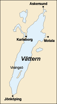
Vättern is a deep, glacially influenced lake with clear, cold water. It is classed as oligotrophic, meaning it has relatively low nutrient concentrations and high transparency. These conditions produce long sight depth and relatively low productivity compared with more eutrophic lakes. The lake contains several islands, the largest of which is Visingsö, and features a shoreline with cliffs, beaches and steep slopes in places. For photographs, maps and visitor information consult visual resources.
Ecology and water quality
The clarity and chemical quality of Vättern's water are notable: many nearby communities draw drinking water directly from the lake with minimal treatment. Because of this reputation it is often mentioned in accounts of significant freshwater resources (water supply, local consumption). The lake supports cold-water fish species and a range of aquatic habitats; however, like all large lakes, it is subject to pressures from land use, point-source discharges and climate variation, and is monitored by regional environmental authorities.
Human uses, towns and recreation
Settlements and historic towns line Vättern's shores, including Jönköping at the southern tip, Motala and Vadstena along the eastern side, and smaller towns such as Hjo, Gränna and Karlsborg. The lake is popular for boating, swimming in summer (water tends to stay cool) and long-distance cycling: the annual Vätternrundan event circles the lake and attracts thousands of riders. Visitors also explore Visingsö island by ferry and enjoy local cultural attractions. General tourism and visitor guidance are available from regional sites (fishing, tourist information).
Fishing, regulation and species
Vättern supports both commercial and recreational fisheries. Important species include brown trout, Arctic char, whitefish, pike, perch and burbot. Recreational anglers and holidaymakers may fish in many areas under license and must follow rules that restrict certain gear and methods; for example, net use for casual sport fishing by visitors is limited in many places. See official regulations and visitor guidance (sport rules, visitor fishing, gear restrictions).
History and management
The lake basin was shaped during and after the last Ice Age and has hosted human communities for millennia. Medieval towns on its shores played roles in regional trade and culture. Modern management focuses on protecting drinking water quality, conserving sensitive fish populations and balancing recreation with ecological limits. Regional authorities and local organizations coordinate monitoring, habitat protection and land-use planning to maintain the lake's condition for future generations.
- Quick facts: area ~1,912 km²; max depth ~128 m; average depth ~40 m.
- Major towns: Jönköping, Motala, Vadstena, Hjo, Gränna, Karlsborg.
- Notable island: Visingsö.
For more detailed maps, ecological reports and visitor services consult regional resources and local authorities linked above. These sources provide up-to-date guidance on water quality, fishing licenses and seasonal activities around Vättern.
Related articles
Author
AlegsaOnline.com Vättern: Sweden's second-largest lake Leandro Alegsa
URL: https://en.alegsaonline.com/art/104362
Sources
- books.google.com : "The Physical Geography of Fennoscandia"