Canton of Vaud
Vaud [ˈvaːt] (abbreviation VD; Swiss German Wadt [ʋɑtː], French Vaud [vo], Italian Vaud (obsolete: Vado), Rhaeto-Romanic![]() ) is a canton in Romandy, the francophone part of Switzerland, and is part of the Geneva-Lausanne metropolitan region. The capital and most populous political municipality is Lausanne.
) is a canton in Romandy, the francophone part of Switzerland, and is part of the Geneva-Lausanne metropolitan region. The capital and most populous political municipality is Lausanne.
The canton is called Vaud or Vaudland, in French Pays de Vaud. The inhabitants are called Vaudois, in French Vaudois [vodwa].
In terms of area, Vaud is the largest canton belonging entirely to French-speaking Switzerland and the fourth largest canton in the country; in terms of population, it ranks third. Vaud has only existed in its present form since the Act of Mediation and the accession of the now independent territory, which had split off from Bern, to the Swiss Confederation on 19 February 1803.
Name
The name goes back to pre-High German wald- "forest" and means "wooded land". The French Vaud (originally pronounced [vawd]) still reflects the vocalization of the pre-High German /l/ and the resulting diphthong, whereas the monophthongized Franco-Provençal pronunciation Vad [vaːd] has been preserved in the German form Waadt.
Geography
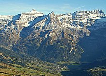
The highest point is Les Diablerets (3210 m above sea level), the lowest point is on Lake Geneva at 372 m above sea level.
The canton of Vaud is located in the west of Switzerland and stretches from Lake Geneva to Lake Neuchâtel. It borders the French departments of Ain, Jura, and Doubs to the northwest, the canton of Geneva to the southwest, Valais to the southeast, the cantons of Fribourg and Bern to the east, and Neuchâtel to the northeast. Beyond Lake Geneva, Vaud borders the department of Haute-Savoie to the south.
The northwest of Vaud is occupied by the Jura, the southeast by the Alps. The rest is located on the Central Plateau. Apart from the canton of Bern, the canton of Vaud is thus the only canton in Switzerland to have a share in all three of Switzerland's major regions.
To the northeast, the district of Avenches forms an exclave enclosed by the canton of Fribourg. On the other hand, three enclaves of Fribourg are located in Vaud. In the southwest of the canton, Céligny is an enclave of the canton of Geneva.
Waters
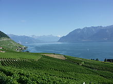
The lakes cover a total surface area of 393 square kilometres (12.23 percent), while the rivers and streams cover 9.4 square kilometres (0.29 percent) of the canton's total area. The most important body of water is Lake Geneva, which runs along almost the entire southern border of the canton. The most important lakes, which lie entirely within the canton, include Lac Brenet, Lac de Joux, Lac de Bret and the Lac de l'Hongrin reservoir. The main rivers are the Orbe, the Broye, the Venoge, the Mentue and the Aubonne.
All lakes in the canton are monitored and clean, so that swimming, sailing, windsurfing or fishing is possible without danger.
Mountains
The highest mountains, at 3210 metres above sea level, are Les Diablerets in the south-east of the canton. Other important mountains are the Dent de Jaman, the Jorat, the Oldenhorn, the Rochers de Naye, the Chasseron, the La Dôle, the Mont Risoux and the Mont Tendre.
Geology
Along the Jura, the earth layer is covered by Jurassic limestone-Nagelfluh, under which there is a red molasse. Near Orbe, between Echallens and Yverdon, there is a large area of Knauermolasse. Not far away, at Onlens and Goumoëns, there is brown, bituminous freshwater limestone, covered only by a dam soil.
At Lausanne, the capital, one sees a denuded rock in the upper part of the city. This is intersected by a road tunnel to the west of the Château Saint-Maire, with quarries to the east. The type of stone is defined as bluish grey marl molasse and sandy marl, blue at depth and yellow at height.
Vaud is characterised by undulating hills and many fertile valleys.

enlarge and show information about the picture
![]()
View from the Chasseron to the cantonal border with Neuchâtel
Climate
The climate in Vaud is distributed very differently. The maximum average temperature is about 14 °C, the minimum about 6 °C. The average annual rainfall is 1100 to 1200 mm with 104 rainy days per year. The sunshine hours are about 5.7 hours.
However, the Gros de Vaud, for example, has a mild and relatively dry climate despite its altitude. Due to the low altitude behind the Jura mountains, which is particularly pronounced during westerly and north-westerly rainfall, the annual average precipitation is relatively low by Swiss standards, ranging from around 900 to 1000 mm.
Climate table
| Monthly average temperatures and precipitation for Geneva (temperatures, sunshine hours and rainy days) and Pully (precipitation)
Source: Temperature, sunshine hours, rainy days and water temperature: The International Climate Index, precipitation: klimadiagramme.de | ||||||||||||||||||||||||||||||||||||||||||||||||||||||||||||||||||||||||||||||||||||||||||||||||||||||||||||||||||||||||||||||||||||||||||||||||||||||||||||||||||||||||||||||||||||||||||||||||||||||||||||||||||||||||||||||

Les Diablerets - highest elevation in the canton

Lake Geneva and the Lavaux wine region
Search within the encyclopedia