South Magnetic Pole
The South Magnetic Pole is the location in the Southern Hemisphere where Earth's magnetic field points vertically upward; its position slowly shifts with changes in the planet's magnetic field.
The South Magnetic Pole is the point on or near Earth's surface in the Southern Hemisphere where the planet's magnetic field is oriented straight upward (that is, magnetic inclination is +90°). It is distinct from the geographic South Pole and from the south pole of a simple bar magnet. The magnetic pole is not fixed: it wanders as Earth's internal magnetic field evolves. Cartographers, navigators and geophysicists therefore treat it as a moving, measurable feature rather than a permanent marker.
Image gallery
3 Images

Definition and basic characteristics
By definition the South Magnetic Pole is the location where a freely suspended magnetic needle would point straight up; in practice the pole is located where the magnetic inclination reaches +90°. This concept depends on Earth's overall magnetic field rather than the geographic spin axis. The term relates to large-scale field structure produced by motions in Earth's liquid outer core. The pole is usually reported with geographic coordinates and an uncertainty range because local surveys and global models differ slightly.
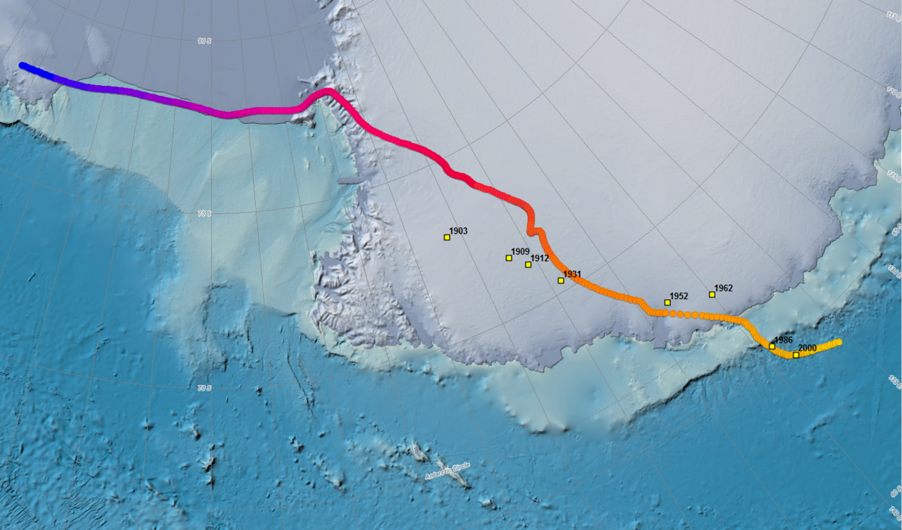
Observed position and drift
Because Earth's magnetic field changes slowly through time, the position of the South Magnetic Pole also changes. Recent scientific estimates have placed it off the coast of Antarctica. For example, one estimate published for 2020 located the pole near the coordinates 64°04′S 135°53′E, while a prior estimate for 2015 placed it near 64°17′S 136°35′E. Those published positions indicate a northwestward movement of roughly 10–15 kilometres per year in recent decades. The pole's distance from the geographic South Pole is on the order of a few thousand kilometres.
Measurement and mapping
Locating the South Magnetic Pole combines field observations from ships, aircraft and Antarctic stations with global magnetic field models. Instruments measure the three components of the field—declination, inclination and intensity—and mathematical models interpolate a best-fit pole location. Modern magnetic maps and navigation systems incorporate time-dependent models so that the changing pole position can be accounted for by users relying on magnetic compasses or by scientists studying core dynamics.
History, exploration and scientific importance
Historical expeditions sought magnetic poles to understand Earth’s magnetism and to improve navigation. Visits to the vicinity of the South Magnetic Pole have been occasional because of the region’s remoteness and harsh climate. Scientific interest remains high: tracking the pole helps researchers monitor core processes that drive secular variation, investigate magnetic reversals in the geologic past, and understand how the magnetosphere interacts with the solar wind. Geophysical anomalies such as mass concentrations (mascons) in regions like Wilkes Land have drawn attention because they may relate to crustal and mantle structures that influence local magnetic signatures.
Uses, distinctions and notable facts
- Navigation: compass-based bearings are referenced to magnetic poles; users must correct for local declination when converting between magnetic and geographic directions.
- Scientific monitoring: shifting pole positions are tracked by agencies that publish time-dependent field models used by navigation, surveying and space-weather communities.
- Distinction from other poles: the South Magnetic Pole differs from the geographic South Pole and from the South Geomagnetic Pole (a center of a simplified dipole fit).
- Nearby infrastructure: the nearest permanent research facility to the modern pole estimates is the French Dumont d'Urville Station, which supports scientific work in the region.
For further reading on related concepts and detailed datasets, consult resources about the southern hemisphere, the nature of magnetic lines, simple magnet models, Earth's magnetic field, specific estimates and published coordinates. For geographic context see the Antarctic Circle and the Geographic South Pole, and for local science support facilities consult information about Dumont d'Urville Station.
Questions and answers
Q: What is the South Magnetic Pole?
A: The South Magnetic Pole is the point on the southern hemisphere where the magnetic lines are directly pointing upward. In other words, if there were a magnet inside the earth axis (from north to south), the South Magnetic pole would be at its southern end.
Q: How often does its location change?
A: Because the magnetic field of the Earth changes, the exact location of this pole does as well.
Q: Where was it estimated to be in 2020?
A: In 2020, it was estimated to be at 64°04′S 135°53′E / 64.07°S 135.88°E / -64.07; 135.88Coordinates: 64°04′S 135°53′E / 64.07°S 135.88°E / -64.07; 135.88, placing it off the coast of Antarctica.
Q: Where was it located in 2015?
A: In 2015, it was at 64°17′S 136°35′E / 64.28°S 136.59°E / -64.28; 136
Related articles
Author
AlegsaOnline.com South Magnetic Pole Leandro Alegsa
URL: https://en.alegsaonline.com/art/92182
Sources
- ngdc.noaa.gov : "Wandering of the Geomagnetic Poles"
- ngdc.noaa.gov : "Geomagnetism Frequently Asked Questions"
- geomag.bgs.ac.uk : British Geological Survey - Magnetic Poles