Polar low — mesoscale cyclones of the polar oceans
Compact, short-lived low-pressure cyclones over high-latitude seas. Produce gale winds, heavy snow and hazardous seas; important for shipping, offshore operations and high-latitude forecasting.
Overview
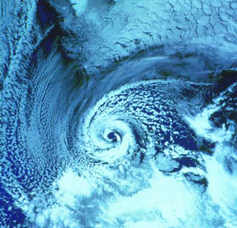
A polar low is a compact, short-lived cyclonic weather system that develops over high-latitude ocean regions. It is a type of low-pressure system with a cold core and a horizontal scale much smaller than ordinary mid-latitude depressions. Polar lows occur in both the Northern Hemisphere and the Southern Hemisphere and belong to the broader class of mesoscale weather phenomena. Typical diameters are commonly measured in tens to a few hundred kilometres and lifetimes range from several hours up to a couple of days.
Image gallery
5 Images


Formation and structure
Polar lows most often form when an intrusion of very cold air passes over relatively warm open water, producing strong destabilisation of the lower atmosphere. Strong heat and moisture fluxes from the sea surface, together with low static stability, support vigorous convection and narrow bands of heavy precipitation. Two common morphological types are described: comma-shaped systems with a pronounced frontal cloud band, and more symmetric, spiral or "eye-like" vortices sometimes compared visually to small tropical storms. Near-surface winds can reach gale strength or higher; modern usage often reserves the term "polar low" for systems that produce near-surface winds of at least gale force (about 17 m/s).
- Characteristics: compact diameter, sharp pressure gradients, intense near-surface winds, convective precipitation (snow, sleet) and rapid development.
- Driving processes: baroclinic instability associated with horizontal temperature contrasts, low-level convective overturning fed by ocean heat fluxes, and enhanced vorticity in pre-existing disturbances.
Typical locations and seasonality
Polar lows are most frequent where cold continental or polar air flows over relatively warm ocean currents or open water near sea-ice margins. Well-known regions of occurrence include the Norwegian and Barents Seas, the Sea of Japan, the Labrador Sea, the Greenland Sea and sectors of the Southern Ocean around Antarctica. They are primarily a cold-season phenomenon and are most common in late autumn through early spring, when air–sea temperature contrasts are largest and synoptic-scale cold outbreaks are frequent.
Impacts and hazards
Despite their limited horizontal extent, polar lows can produce hazardous conditions across wide marine and coastal areas. Typical impacts include rapid-onset gales, intense snow squalls and whiteout conditions, very rough seas and icing of exposed structures. These effects pose particular risks to:
- shipping and small craft operations;
- offshore oil and gas platforms and coastal installations;
- fisheries, search-and-rescue operations and coastal communities;
- low-level aviation in high-latitude regions.
Detection and forecasting
Polar lows can be difficult to detect with conventional observation networks because of their mesoscale size and short life. Satellite imagery — visible and infrared plus microwave soundings from polar-orbiting satellites — has become crucial for identifying developing systems and monitoring their evolution. High-resolution numerical weather prediction models, targeted surface and ship observations, and rapid nowcasting methods improve situational awareness, but operational forecasting of polar lows remains challenging and often requires forecasters to issue localized warnings on short notice.
Terminology, research and climate considerations
Historically polar lows have been described by many names, including comma cloud, mesocyclone, polar mesoscale vortex, Arctic hurricane and cold-air depression. Contemporary usage typically reserves "polar low" for the more energetic instances that generate gale-force winds. They are dynamically distinct from larger extratropical cyclones (which are broader and longer-lived) and from tropical cyclones (which have a warm core and different energy sources).
Scientific research continues to refine understanding of polar-low dynamics, predictability and climatology. Important topics include the role of sea-ice extent and ocean temperature gradients, the interactions with larger-scale atmospheric patterns, and how a warming polar climate may influence the frequency, intensity or preferred locations of these systems. While some model studies suggest changes in occurrence patterns as polar regions warm, the subject remains an active area of research with ongoing uncertainty.
Operational and historical notes
Polar lows have long been a concern for mariners and polar operators because of their ability to produce rapid and localized deterioration of weather. Improved satellite coverage since the late 20th century, combined with higher-resolution forecasting models, has enhanced detection and warnings. Case studies of notable polar-low events are used in training for forecasters and emergency planners in high-latitude countries.
For further technical and operational guidance see synoptic and mesoscale resources specific to polar regions, including materials on low-pressure systems, regional case studies in the Northern Hemisphere and methodologies for mesoscale analysis and forecasting.
Related articles
Author
AlegsaOnline.com Polar low — mesoscale cyclones of the polar oceans Leandro Alegsa
URL: https://en.alegsaonline.com/art/77699