Ottauquechee River
A roughly 40-mile river in central Vermont that rises in the Green Mountains, flows east through Rutland and Windsor counties, forms Quechee Gorge, and joins the Connecticut River at Hartland.
The Ottauquechee River is a comparatively short but regionally important waterway in Vermont, in the eastern United States. Approximately 40 miles (64 km) in length, it is a tributary of the Connecticut River and contributes to that larger river basin. The river is known for its wooded valleys, seasonal flow variations, and a number of scenic and recreational sites along its course.
Image gallery
3 Images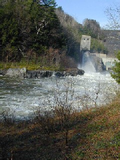


Course and physical characteristics
The Ottauquechee rises in the highlands of the Green Mountains and descends to lower elevations as it travels generally eastward. It flows across parts of Rutland County and Windsor County before meeting the Connecticut River in the town of Hartland. Its valley cuts through bedrock in places, producing steeper channels and small falls as well as broader meadows and floodplain reaches downstream.
Notable places and geology
One prominent feature formed by the river is Quechee Gorge, a deep, rocky gorge carved by the stream and popular with visitors for its dramatic cliffs and views. The gorge and surrounding areas host hiking trails and overlooks; fall foliage and winter scenes attract photographers and nature enthusiasts. Smaller cascades, riffles, and pools along the Ottauquechee create varied habitat and visual interest.
History and name
The river’s name comes from Indigenous languages of the region, reflecting the long human association with the land and waters. European settlers in New England also made use of the river’s flow: small mills and bridges were established at convenient drops and crossings, and settlements grew where roads and waterpower met. Over time the river has remained a focus for local communities and outdoor recreation.
Uses, ecology, and recreation
The Ottauquechee supports cold-water fisheries and typical New England stream life; trout and other freshwater species are found in suitable reaches. Recreational uses include fishing, paddling, swimming in calmer pools, and riverside hiking. Local parks and access points make the river a resource for nearby towns, and seasonal flood patterns are an important consideration for landowners and managers.
Management, infrastructure, and reservoirs
A dam on the Ottauquechee forms North Hartland Lake; the impoundment and associated facilities are managed for flood risk reduction, recreation, and related purposes. The reservoir and dam influence downstream flows and are part of broader watershed planning. For further details about river management and recreation sites see resources linked below.
- Key facts: length ~40 miles; rises in the Green Mountains; enters the Connecticut River at Hartland.
- Notable site: Quechee Gorge and nearby state park facilities.
- Reservoir: North Hartland Lake (formed by a dam on the Ottauquechee) — North Hartland Lake.
- Typical activities: fishing, hiking, paddling, scenic viewing.
- Counties traversed: Rutland County and Windsor County in Vermont.
- Hydrological role: a tributary (tributary) of the Connecticut River system.
For maps, land-use details, and recreational information consult regional guides and official resources maintained by state and watershed organizations. Additional context about the river’s role in local history and conservation is available through community and conservation groups working in the Ottauquechee watershed.
See also local site listings and visitor information: Ottauquechee River, Vermont, eastern United States, and the river’s connection as a tributary to the Connecticut River. Additional reservoir and management references: North Hartland Lake.
Related articles
Author
AlegsaOnline.com Ottauquechee River Leandro Alegsa
URL: https://en.alegsaonline.com/art/73522