Ouaka (prefecture of the Central African Republic)
Ouaka is a central prefecture of the Central African Republic with its capital at Bambari. It is named for the Ouaka River and borders the Democratic Republic of the Congo; the region is primarily agricultural.
Overview
Ouaka is one of the prefectures that make up the Central African Republic; its administrative centre is the town of Bambari. The name derives from the Ouaka River, which is a notable geographic feature of the area. Ouaka forms part of the country’s central network of provinces and is linked by land and seasonal river routes to neighbouring regions.
Image gallery
3 Images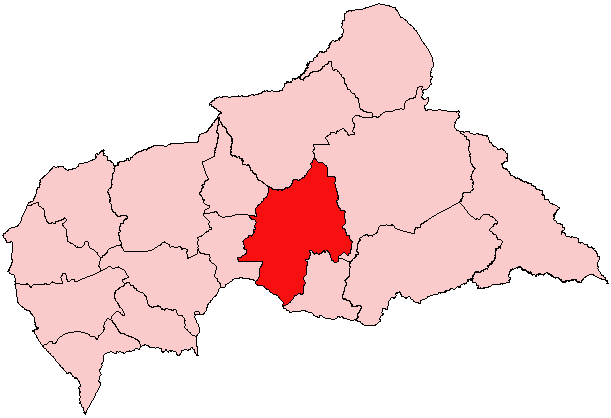

Location and geography
Located in the central part of the country, Ouaka contains a mix of savanna and wooded areas. Rivers and seasonal streams influence settlement patterns and agriculture. The prefecture shares a boundary with the Democratic Republic of the Congo, which affects cross-border trade and movement.
- Administrative capital: Bambari
- Major natural feature: Ouaka River
- International border: Democratic Republic of the Congo
Administration and population
Ouaka is administered as a prefecture within the national system. Bambari functions as the political and commercial hub, hosting regional services and markets. The population is predominantly rural, with communities engaged in subsistence and smallholder farming, local trade and artisanal activities.
Economy and infrastructure
The local economy depends largely on agriculture, forestry and local commerce. Infrastructure is limited: road quality varies and many routes are seasonal. Rivers can provide transport during certain months, but access to larger national and international markets is constrained by logistics and periodic insecurity.
History and contemporary issues
Like other parts of the country, Ouaka has experienced episodes of political tension and armed conflict, which have affected civilians and disrupted economic activity. Humanitarian and development actors operate in the area when access permits. The prefecture’s location and resources make it important for regional recovery and stabilization efforts.
Further information
For context about administrative divisions see the list of prefectures. For national background consult the Central African Republic overview. Cross-border relations and regional maps often reference the border with the Democratic Republic of the Congo.
Related articles
Author
AlegsaOnline.com Ouaka (prefecture of the Central African Republic) Leandro Alegsa
URL: https://en.alegsaonline.com/art/73575
Sources
- stat-centrafrique.com : "Population Prefecture"
- statoids.com : "Central African Republic Prefectures"
- tools.wmflabs.org : 6°00′N 21°00′E / 6.000°N 21.000°E / 6.000; 21.000