Krafla: volcanic caldera and geothermal system in northern Iceland
Krafla is a volcanic caldera and active geothermal area in northern Iceland known for its fissure system, the Víti crater, historic eruptions in the 1970s–80s and nearby geothermal power development.
Overview
Krafla is a prominent volcanic caldera in the north of Iceland. The feature is part of a larger volcanic system that straddles the Mid‑Atlantic Ridge and the Iceland hotspot. Its caldera measures roughly 10 kilometers across and sits within a regional fissure zone important for both volcanic activity and geothermal heat flow.
Image gallery
4 Images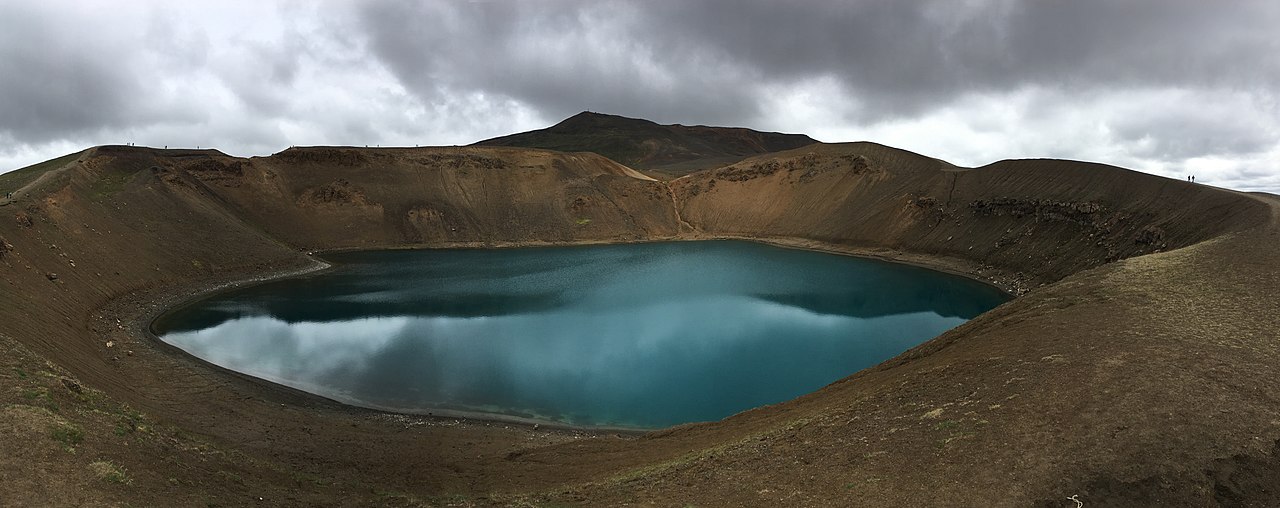


Geology and physical features
Krafla is classed as a caldera structure formed by repeated eruptions and collapse. The surrounding fissure zone extends about 90 kilometers and has produced extensive lava fields and craters. The highest point within the system reaches about 818 metres above sea level (2,684 ft), and the area includes steaming vents, fumaroles and hot ground associated with shallow magma bodies and circulating hydrothermal fluids.
Eruptive history
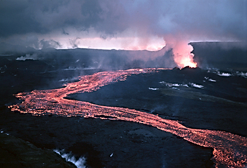
Krafla is among Iceland's most active volcanic areas in recorded times. Notably, a sequence of rifting episodes and eruptions—often referred to collectively as the Krafla Fires—occurred in the late twentieth century and attracted scientific attention for magma intrusion, ground deformation and surface lava flow formation. These events illustrate how fissure eruptions and caldera collapse interact in rift zones.
Human use, research and tourism
The area around Krafla is used for geothermal power production, field studies and guided visits. A geothermal power station nearby harnesses steam and hot water for electricity and heating, and scientists study the site to better understand rifting, magma supply and geothermal systems. Visitors commonly access safe viewpoints and trails to inspect lava fields and steaming vents.
Notable features and cultural notes
Within the caldera sits the crater called Víti, one of two famous craters in Iceland with that name; the other is located in Askja. The Icelandic word "víti" traditionally means "hell", reflecting old folklore that associated volcanic pits with the underworld. Víti at Krafla contains a distinctive green lake and is a frequently photographed landmark.
Quick facts
- Caldera diameter: about 10 km.
- Fissure zone length: roughly 90 km — a regional tectonic rift belt (fissure zone).
- Highest elevation in the system: around 818 m (2,684 ft).
Krafla remains both a natural laboratory for volcanologists and a distinctive element of Iceland's volcanic landscape, combining active geology, renewable energy use and accessible scenic features for visitors.
Related articles
Author
AlegsaOnline.com Krafla: volcanic caldera and geothermal system in northern Iceland Leandro Alegsa
URL: https://en.alegsaonline.com/art/54399