Kyushu–Palau Ridge
Undersea volcanic ridge in the Philippine Sea running southeast from Kyushu toward Palau. A remnant island-arc chain of extinct volcanoes studied for tectonics, seafloor geology and marine habitats.
The Kyushu–Palau Ridge is a major bathymetric feature of the Philippine Sea, forming a long chain of seafloor highs and extinct volcanic structures that trends roughly southeast from southwestern Japan toward Micronesia. The ridge takes its name from the Japanese island of Kyushu at its northern end and the island nation of Palau near its southern terminus. It is not a spreading mid-ocean ridge but a volcanic arc remnant that records past subduction and arc-building processes beneath this part of the western Pacific.
Image gallery
10 Images


Location and visible features
The ridge begins in the north in the region offshore of Kyushu and in proximity to the mouth of the Bungo Channel, between Kyushu and Shikoku. From there it extends in a southeastward line across the basin of the Philippine Sea toward the islands of Micronesia and the general direction of the Pacific island chains. Along its length are seamounts, guyots (flat‑top seamounts), and other volcanic edifices which appear as a structural line on modern bathymetric maps.
Geological origin and development
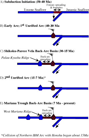
Geologists interpret the Kyushu–Palau Ridge as the remnant of an island arc system produced by magmatism associated with subduction in the western Pacific. Over millions of years, volcanic growth, subsequent dormancy and subsidence shaped the line of seafloor highs seen today. The ridge preserves evidence used to reconstruct the migration of arc volcanism, changes in plate motions, and episodes of seafloor spreading that affected the surrounding basins.
Scientific importance and uses
The KPR is important to several fields of marine science and geophysics. It provides a natural laboratory for:
- studying island‑arc evolution and the products of arc volcanism preserved on the ocean floor;
- mapping seafloor bathymetry and sedimentation patterns that record past sea‑level and tectonic events;
- sampling dredged volcanic rocks and sediments to date volcanic episodes and infer paleogeography;
- examining biological communities that colonize seamounts and shallow summits, which can differ markedly from surrounding deep seafloor habitats.
Research methods and observations
Knowledge of the ridge comes from shipborne bathymetric surveys, seismic reflection and refraction studies, submersible observations, and rock sampling. These techniques reveal the morphology of individual seamounts, the composition of volcanic rocks, and the internal structure of the ridge beneath sediment cover. The feature is often cited in regional syntheses of western Pacific tectonics and is a target for multidisciplinary oceanographic research.
Distinctions and notable facts
Although often referred to as a ridge, the Kyushu–Palau Ridge differs from oceanic spreading ridges: it represents an older, volcanic arc-related construction rather than a present-day divergent plate boundary. Its alignment between Kyushu and Palau connects geological histories of northern and southern parts of the Philippine Sea, making it a key feature for understanding how island arcs and basins in this part of the Pacific have evolved. Ongoing mapping and sampling continue to refine its age relationships and the role it played in regional plate interactions.
Questions and answers
Q: What is the Kyushu-Palau Ridge?
A: The Kyushu-Palau Ridge is an ocean floor feature in the Philippine Sea that creates a line on the ocean floor which runs southeast in the direction of the island of Palau.
Q: Why is it called Kyushu-Palau Ridge?
A: It is named after the nearby islands, with the northern end at the Japanese island of Kyushu and the southern end at the Pacific island nation of Palau.
Q: Where does the Kyushu-Palau Ridge begin?
A: The seabed ridge begins in an area about 900 km from the eastern end of the Bungo Channel (豊後水道, Bungo Suidō) or "Bungo strait" between the Japanese islands of Kyushu and Shikoku.
Q: Which direction does the ridge run in?
A: The ridge runs southeast in the direction of the island of Palau.
Q: What is located on the Kyushu-Palau Ridge?
A: There is a chain of extinct volcanos located on the ridge.
Q: Where is the KPR in relation to the Japanese island of Kyushu?
A: The KPR is located southeast of the Japanese island of Kyushu.
Q: What body of water is located at the eastern end of the KPR?
A: The Bungo Channel or "Bungo strait" is located at the eastern end of the KPR between the Japanese islands of Kyushu and Shikoku.
Related articles
Author
AlegsaOnline.com Kyushu–Palau Ridge Leandro Alegsa
URL: https://en.alegsaonline.com/art/54795
Sources
- gebco.net : "IHO-IOC GEBCO gazetter of undersea feature names," Publication B-8, January 2010, p236
- adsabs.harvard.edu : "Origin of the Palau and Yap trench-arc systems,"
- adsabs.harvard.edu : "The early Miocene (~25 Ma) volcanism in the northern Kyushu-Palau Ridge, enriched mantle source injection during rifting prior to the Shikoku backarc basin opening,"