Kansas's 4th congressional district
A U.S. congressional district in south-central Kansas centered on Wichita. It combines urban and rural areas, is an aviation and manufacturing hub, and has tended toward Republican representation.
Overview
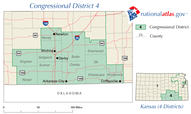
Kansas's 4th congressional district is a federal electoral district in the south-central portion of the U.S. state of Kansas. The district is anchored by the city of Wichita and the surrounding communities, and it is commonly referenced in discussions of the state's urban-rural mix and industrial base. For official information and maps see the district page: district details.
Image gallery
10 Images


Geography and composition
The district covers Wichita and nearby towns, extending into adjoining counties to include suburban and agricultural areas. Its boundaries have shifted after census-driven redistricting, which can change which communities fall inside the district while keeping Wichita as its primary population center.
Economy, institutions and culture
The local economy blends urban industry and rural agriculture. Wichita is known as an aviation and production center, home to major aircraft manufacturing and related suppliers. The district also contains educational and medical institutions, and a military presence around key bases and installations. Economic sectors commonly cited include aerospace, manufacturing, healthcare, education and farming.
Political history and significance
Politically, the 4th district has been an important seat in Kansas politics. In recent decades it has leaned toward the Republican Party in federal elections, reflecting a mix of conservative suburban and rural voters alongside a more diverse urban electorate in Wichita. Redistricting and demographic change periodically affect electoral dynamics.
Notable facts and community highlights
- Major population center: Wichita.
- Known for aviation manufacturing and related supply chains.
- Contains higher education institutions and significant healthcare providers.
- Boundaries and political balance can shift after each decennial census (state redistricting updates).
The district combines urban amenities and cultural institutions with wide agricultural plains and manufacturing plants, making it a microcosm of south-central Kansas economic and political life. For maps, voter information and current representation consult official sources and local election offices: district details, state resources.
Related articles
Author
AlegsaOnline.com Kansas's 4th congressional district Leandro Alegsa
URL: https://en.alegsaonline.com/art/52196
Sources
- census.gov : My Congressional District
- cookpolitical.com : "Partisan Voting Index – Districts of the 115th Congress"
- kansas.com : "Court releases redistricting plans; bad news for two conservative Senate hopefuls,"
- pratttribune.com : "Judges' decision moves Pratt County into 4th Congressional District,"
- tools.wmflabs.org : 37°30′N 97°12′W / 37.5°N 97.2°W / 37.5; -97.2