
Congressional district
A congressional district is a geographic electoral area that elects a representative to a national legislature. Districts vary by country, size, method of election and rules for drawing boundaries.

A congressional district is a type of electoral constituency established to elect one or more members to a national legislative body commonly called a congress. In practice the term is most often used for single-member districts that return one representative. The area of a district is determined by legal and administrative rules and is intended to provide representation for the people who live within its boundaries.
Image gallery
2 Images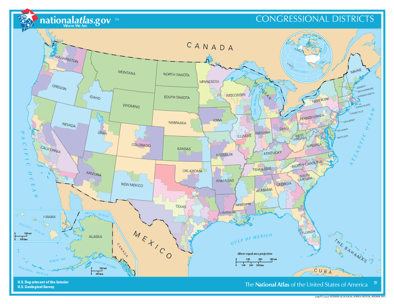

Characteristics and structure
Districts are defined by geographic boundaries that attempt to group voters into units of roughly equal population so that each representative speaks for a similar number of constituents. Boundaries may follow municipal lines, natural features, or be drawn to include certain communities. Systems differ: some countries use single-member districts, while others employ multi-member districts or at-large seats. Size and shape therefore vary widely between urban and rural areas.
How districts are created and adjusted
Apportionment and redistricting are the two main procedures that determine district lines. Apportionment allocates the number of seats among regions or states based on population counts, often from a national census. Redistricting redraws the internal boundaries to maintain equal representation as populations shift. Legal principles such as population equality, contiguity, and respect for communities of interest guide the process, though political considerations sometimes influence outcomes.
Examples and international use
Several countries use the term and concept of congressional districts. Notable examples include the United States, Japan, and the Philippines, each with national rules that shape how districts are apportioned and contested. Within those systems, districts can be paired with different voting methods, such as plurality, runoffs, or mixed-member systems.
Importance and common issues
Congressional districts determine how voters are represented in national lawmaking and influence electoral competition, party balance, and policy priorities. Controversies often arise over gerrymandering—when boundaries are drawn to favor a party or incumbent—and over disparities between urban and rural representation. Alternatives to district-based representation include proportional systems that allocate seats based on overall vote shares rather than geography.
Distinctive facts
- District sizes aim for demographic parity but will differ because of legal limits and geographic realities.
- Some nations allow independent or judicial review of maps to reduce partisan bias.
- Variations include at-large districts, multi-member districts, and hybrid systems combining district seats with party lists.
For further reading on electoral geography, the mechanics of redistricting, and comparative districting practices, consult general resources on electoral systems and legislative apportionment. See also discussions of representative fairness and legal standards used in different countries.
Electoral constituency overview | Legislative bodies | Japan example | Philippines example | United States example

Statistics
- The largest congressional electoral district by area is the Alaska At-Large electoral district, which is coterminous with the U.S. state of Alaska, at 1,717,854 square miles.
- In fifth place is that largest congressional election district in the U.S., but part of a state, New Mexico's 2nd Congressional District, which is 185,805 square miles.
- 9 of the 10 smallest congressional election districts in the USA are in New York, including the smallest of all 435 congressional election districts with an area of 26.5 km²: the 13th election district of New York.
The 20 largest constituencies
| No. | District | Area in km² | Member(s) (from 2021) |
| 1 | Alaska At-large | 1.481.354 | Don Young (R) |
| 2 | Montana At-large | 376.981 | Matt Rosendale (R) |
| 3 | Wyoming At-large | 251.491 | Liz Cheney (R) |
| 4 | South Dakota At-large | 196.542 | Dusty Johnson (R) |
| 5 | New Mexico-2 | 185.806 | Yvette Herrell (R) |
| 6 | Oregon-2 | 179.857 | Cliff Bentz (R) |
| 7 | North Dakota At-large | 178.648 | Kelly Armstrong (R) |
| 8 | Nebraska-3 | 174.658 | Adrian M. Smith (R) |
| 9 | Texas-23 | 150.374 | Tony Gonzales(R) |
| 10 | Nevada-2 | 144.600 | Mark Amodei (R) |
| 11 | Arizona-1 | 142.553 | Tom O'Halleran (D) |
| 12 | Kansas-1 | 136.086 | Tracey Mann (R) |
| 13 | Nevada-4 | 132.085 | Steven Horsford (D) |
| 14 | Colorado-2 | 128.806 | Joe Neguse (D) |
| 15 | New Mexico-3 | 116.443 | Teresa Leger Fernandez (D) |
| 16 | Idaho-2 | 111.954 | Mike Simpson (R) |
| 17 | Utah-2 | 103.569 | Chris Stewart (R) |
| 18 | Idaho-1 | 102.093 | Russ Fulcher (R) |
| 19 | Texas-13 | 99.325 | Ronny Jackson (R) |
| 20 | Colorado-4 | 98.687 | Ken Buck (R) |
The 20 smallest constituencies
| No. | District | Area in km² | Member(s) (as of 2019) |
| 1 | New York-13 | 27 | Adriano Espaillat (D) |
| 2 | New York-10 | 37 | Jerrold Nadler (D) |
| 3 | New York-15 | 38 | José Serrano (D) |
| 4 | New York-12 | 39 | Carolyn B. Maloney (D) |
| 5 | New York-9 | 41 | Yvette Clarke (D) |
| 6 | New York-7 | 42 | Nydia Velázquez (D) |
| 7 | New York-14 | 74 | Alexandria Ocasio-Cortez (D) |
| 8 | New York-8 | 77 | Hakeem Jeffries (D) |
| 9 | New York-6 | 78 | Grace Meng (D) |
| 10 | California-12 | 101 | Nancy Pelosi (D) |
| 11 | California-34 | 124 | Jimmy Gomez (D) |
| 12 | New York-5 | 135 | Gregory Meeks (D) |
| 13 | Illinois-4 | 136 | Jesús García (D) |
| 14 | New Jersey-8 | 142 | Albio Sires (D) |
| 15 | California-37 | 144 | Karen Bass (D) |
| 16 | California-40 | 150 | Lucille Roybal-Allard (D) |
| - – | District of Columbia At-large | 160 | Eleanor Holmes Norton (D) |
| 17 | Illinois-7 | 162 | Danny K. Davis (D) |
| 18 | Massachusetts-7 | 163 | Ayanna Pressley (D) |
| 19 | New York-11 | 171 | Max Rose (D) |
| 20 | California-46 | 186 | Lou Correa (D) |
Number
According to the 2020 Census, Texas will gain two additional House seats and will have 38 House seats in the future. Further, Colorado (8 in the future), Florida (28), Montana (2), North Carolina (14), and Oregon (6) will each gain an additional constituency. The following seven states will lose a constituency after the 2022 Midterm Elections: Illinois (17 in the future), California (52), Michigan (13), Ohio (15), New York (26), Pennsylvania (17), and West Virginia (2).
| Number of congressional election districts by state | |||
| State | Census 2000 | Census 2010 | Census 2020 |
| 7 | 7 | 7 | |
| 1 | 1 | 1 | |
| 8 | 9 | 9 | |
| 4 | 4 | 4 | |
| 7 | 7 | 8 | |
| 5 | 5 | 5 | |
| 1 | 1 | 1 | |
| 25 | 27 | 28 | |
| 13 | 14 | 14 | |
| 2 | 2 | 2 | |
| 2 | 2 | 2 | |
| 19 | 18 | 17 | |
| 9 | 9 | 9 | |
| 5 | 4 | 4 | |
| 53 | 53 | 52 | |
| 4 | 4 | 4 | |
| 6 | 6 | 6 | |
| 7 | 6 | 6 | |
| 2 | 2 | 2 | |
| 8 | 8 | 8 | |
| 10 | 9 | 9 | |
| 15 | 14 | 13 | |
| 8 | 8 | 8 | |
| 4 | 4 | 4 | |
| 9 | 8 | 8 | |
| 1 | 1 | ||
| 3 | 3 | 3 | |
| 3 | 4 | 4 | |
| 2 | 2 | 2 | |
| 13 | 12 | 12 | |
| New Mexico | 3 | 3 | 3 |
| 29 | 27 | 26 | |
| 13 | 13 | 14 | |
| 1 | 1 | 1 | |
| 18 | 16 | 15 | |
| 5 | 5 | 5 | |
| 5 | 5 | 6 | |
| 19 | 18 | 17 | |
| 2 | 2 | 2 | |
| 6 | 7 | 7 | |
| 1 | 1 | 1 | |
| 9 | 9 | 9 | |
| 32 | 36 | 38 | |
| 3 | 4 | 4 | |
| 1 | 1 | 1 | |
| 11 | 11 | 11 | |
| 9 | 10 | 10 | |
| 3 | 3 | 2 | |
| 8 | 8 | 8 | |
| 1 | 1 | 1 | |
| Total | 435 | 435 | 435 |
Related articles
Author
AlegsaOnline.com Congressional district Leandro Alegsa
URL: https://en.alegsaonline.com/art/22518
Sources
- census.gov : Congressional Apportionment. 2010 Census Briefs