Contiguous United States (the Lower 48)
The contiguous United States — also called the conterminous United States or the Lower 48 — comprises the 48 adjoining U.S. states plus the District of Columbia, excluding Alaska, Hawaii and overseas territories.
Overview
The term contiguous United States refers to the set of 48 U.S. states that share common land borders, together with the District of Columbia. These states form a single continuous landmass within North America and are often called the "Lower 48" in informal usage. The official legal phrasing sometimes uses the word "conterminous." The group of 48 states is treated as a convenient geographic unit in mapping, statistics and many federal programs.
Image gallery
2 Images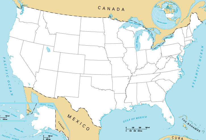

Geography and characteristics
The contiguous United States stretches from the Atlantic seaboard in the east to the Pacific coast in the west, and from the border with Canada in the north to the Mexican frontier in the south. It contains a wide variety of landscapes — from coastal plains and major river valleys to mountain ranges and arid deserts — and spans multiple climate zones and time zones. Because the states touch one another, transportation networks such as interstate highways and mainline rail connect most population centers without crossing large ocean gaps.
History and terminology
The phrase "contiguous United States" predates the admission of Alaska and Hawaii but gained practical prominence after those two states were admitted to the Union in 1959. That admission highlighted the distinction between the united states on the North American landmass and the full set of fifty states plus territories. "Continental United States" is a related term whose usage varies: some people use it interchangeably with "contiguous," while others include Alaska because it lies on the North American continent.
Uses and significance
Government agencies, businesses and researchers often treat the contiguous United States as a single unit for statistics, planning and logistics. Many federal programs, shipping rates, emergency response plans and demographic studies distinguish services that apply only to the contiguous states from those extending to noncontiguous states and territories. Economically and demographically, most U.S. residents and industries are located within this contiguous area, so it frequently forms the default reference for national averages and infrastructure planning.
Excluded states and territories
- Alaska — physically separated from the Lower 48 by Canadian territory.
- Hawaii — an archipelago located well into the central Pacific Ocean.
- American Samoa — an unincorporated territory in the South Pacific.
- U.S. Virgin Islands — Caribbean territories not part of the contiguous landmass.
- Northern Mariana Islands — a U.S. commonwealth in the western Pacific.
- Guam — an organized U.S. territory in the western Pacific.
- Puerto Rico — an island commonwealth in the Caribbean.
Distinctions and notable facts
Because the contiguous United States is the default geographic unit for many maps and datasets, the phrase "outside the contiguous United States" appears in legal texts, shipping terms and travel advisories. Informal names such as the "Lower 48" reflect cultural usage, while formal contexts may prefer "conterminous United States." Understanding the distinction is useful when interpreting statistics, planning logistics or reading legal language that treats noncontiguous states and territories differently.
Related articles
Author
AlegsaOnline.com Contiguous United States (the Lower 48) Leandro Alegsa
URL: https://en.alegsaonline.com/art/22758