Bois de Sioux River
A short river in the upper Red River basin that drains Lake Traverse and helps form the Red River of the North, marking parts of the borders of Minnesota, North Dakota and South Dakota.
Overview
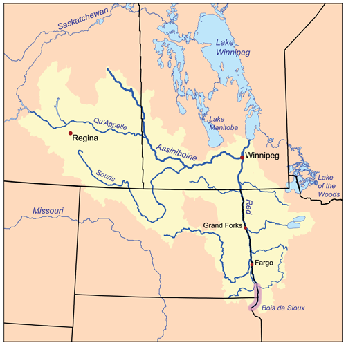
The Bois de Sioux River is a relatively short but regionally important waterway in the upper Red River watershed. It carries the outflow from Lake Traverse, which is notable for being the southernmost lake in the Hudson Bay watershed of North America. Running roughly 41 miles (about 66 km), the Bois de Sioux is counted as a tributary of the Red River of the North, the major northward-flowing river that eventually reaches Hudson Bay.
Image gallery
3 Images

Course and geography
The river flows northward from the outlet of Lake Traverse and joins other streams to form the Red River at the confluence near the towns of Wahpeton, North Dakota and Breckenridge, Minnesota. Along its course the Bois de Sioux traverses a broad, flat plain characteristic of the Red River valley, with slow currents and a meandering channel in places. Geographically the river also has a border role: its channel lies along the western border of the U.S. state of Minnesota while simultaneously defining the eastern boundaries of both North Dakota and South Dakota in different stretches.
Characteristics
- Length: approximately 41 miles (66 km).
- Origin: drains Lake Traverse.
- Terminates by contributing to the Red River of the North.
- Flows north over a low-gradient floodplain typical of the Hudson Bay drainage.
History and name
The river's French name, Bois de Sioux, is commonly rendered as "Woods of the Sioux" and reflects early French and Métis presence in the region and interactions with Dakota and other Plains peoples. The Dakota name for the waterway is Caninkpa Wakpa (can = wood; inkpa = point; wakpa = river), which has been translated as a reference to the river marking a point where wooded country begins in the landscape extending toward Hudson Bay. Indigenous use of the river and surrounding wetlands for travel, hunting and resource gathering predates European exploration.
Ecology, land use and management
Ecologically, the Bois de Sioux flows through a mix of prairie, wetland and agricultural lands. The surrounding valley supports migratory birds, wetland plants and fish communities typical of prairie river systems. Over time the basin has been modified by drainage, channel adjustments and flood-control measures to support farming and protect settlements; these changes influence flow patterns and seasonal flooding. Local and regional agencies manage parts of the river corridor to balance agricultural needs, flood risk reduction and habitat conservation.
Importance and notable facts
Although modest in length, the Bois de Sioux plays a key role in the larger Red River system by conveying Lake Traverse's waters northward and helping to demarcate state boundaries. Its slow-moving nature on a flat plain contributes to seasonal flooding patterns that affect communities downstream along the Red River. For maps, environmental planning and historical study the river is a useful example of how small tributaries can have outsized effects within continental drainage networks such as the Hudson Bay watershed.
If you seek more detailed geographic data, historical accounts, or management plans, consult regional hydrology resources and local conservation agencies that maintain records on the Bois de Sioux corridor and the adjoining states: Minnesota, North Dakota and South Dakota.
Related articles
Author
AlegsaOnline.com Bois de Sioux River Leandro Alegsa
URL: https://en.alegsaonline.com/art/12729
Sources
- viewer.nationalmap.gov : The National Map