South Dakota: geography, history, culture, and key attractions
Concise encyclopedia entry on South Dakota covering geography, statehood, people, economy, cities and notable attractions such as Mount Rushmore, the Black Hills and the Corn Palace.
Overview
South Dakota is a U.S. state in the north-central Great Plains and northern Midwest. It was admitted to the Union on November 2, 1889. The state combines broad agricultural plains and river valleys in the east with the more varied terrain of the west, including the forested granite of the Black Hills. The state capital is Pierre, while the largest city and economic center is Sioux Falls — often referenced in travel and business contexts as Sioux Falls in local guides.
Image gallery
10 Images


Geography and borders
South Dakota stretches from the Missouri River across eastern lowlands into the mixed-grass prairie and the western Black Hills and Badlands. It is bounded by North Dakota to the north, Nebraska to the south, Iowa and Minnesota to the east, and Wyoming and Montana to the west. Major rivers, notably the Missouri, divide east and west and have shaped settlement patterns and transportation routes.
History and people
Indigenous peoples have lived in the region for millennia. Today the state includes several federally recognized Native American tribes; commonly cited counts identify nine tribal nations with reservations and communities in South Dakota. Tribes of the Sioux (Lakota and Dakota) form a significant cultural presence, and Native history is central to the state’s identity. Euro-American settlement increased in the 19th century during the Dakota Territory era, followed by agricultural expansion, rail development and eventual statehood.
Major cities and communities
- Sioux Falls — largest city and regional hub for health care, finance and retail
- Rapid City — gateway to the Black Hills and a major western service center
- Aberdeen — trade and education center in the northeast
- Mitchell — known for the Corn Palace and local festivals
- Pierre — state capital, centrally located and smaller than most state capitals
Economy, culture and society
Agriculture is a cornerstone of the economy: large-scale crop production (corn, soybeans and wheat) and livestock farming are widespread. Mining, timber in limited areas, light manufacturing and expanding service sectors, especially health care and education, also contribute. Tourism is important in the west, centered on outdoor recreation, historic sites and cultural attractions. Cultural life blends Native American heritage, frontier history and rural traditions, visible at museums, powwows, county fairs and statewide events.
Attractions and recreation
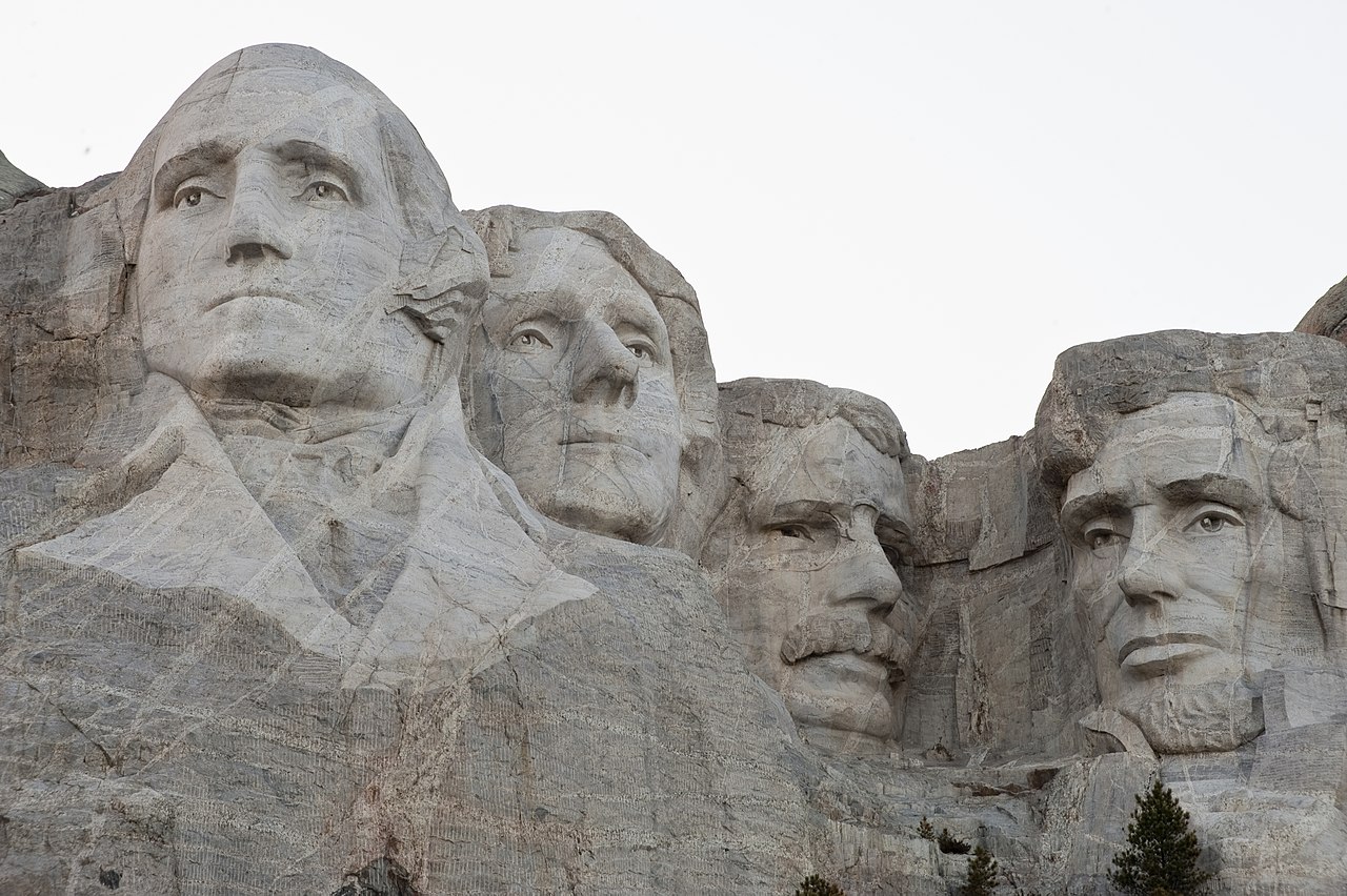
Visitors come for both natural scenery and iconic monuments. Notable attractions include Mount Rushmore and the surrounding Black Hills, roadside destinations such as Wall Drug, and seasonal festivals that celebrate local agriculture and artisan crafts. The Corn Palace in Mitchell is a distinctive local landmark. The Badlands National Park and numerous state parks offer hiking, wildlife viewing and fossil sites.
Government, education and transport
South Dakota has a state government with executive, legislative and judicial branches and a network of counties and municipalities. Public education includes statewide K–12 systems and several colleges and universities that serve regional needs. Transportation is dominated by a highway network and regional airports; larger cities provide rail and bus connections for freight and passengers.
South Dakota’s mix of wide-open landscapes, small-town life and sites of national interest makes it a distinct part of the American interior, with contemporary communities and deep historical ties to the Indigenous nations who have long called the region home.
Geography
Neighbouring countries
South Dakota borders North Dakota to the north, Minnesota and Iowa to the east, Nebraska to the south, and Wyoming and Montana to the west.
Structure
The state is divided into 66 counties.
History
The Dakota Territory was a territory of the United States. In 1889, it was divided into northern and southern halves. These territories, North Dakota and South Dakota, were admitted to the United States as the 39th and 40th states.
On December 29, 1890, the Seventh U.S. Cavalry massacred over 300 Minneconjou, Lakota, and Sioux men, women, and children under Chief Si Tanka at Wounded Knee. This massacre broke the last resistance of the Indians against the whites. On February 27, 1973, members of the American Indian Movement resistance organization, along with sympathizers from the Pine Ridge Reservation, occupied the village of Wounded Knee and proclaimed the independent Oglala Nation.
Beginning in 1944, dams were built along the Missouri River to protect downstream residents from flooding. For this purpose, several tribes were forcibly relocated and their land disappeared under the water of reservoirs such as Big Bend and Oahe. In 2010, the affected tribes demanded compensation for the destruction of their land. Of the seven tribes affected, the Standing Rock Sioux, Cheyenne River Sioux, Crow Creek Sioux, Lower Brule Sioux, and Yankton Sioux live in South Dakota. The Crow Creek Sioux reservation was flooded by the Big Bend Dam, built in 1959-63. Their facilities had to be moved to Pierre. The tribes are suing not only for compensation for the loss of their land and property, but also to share in its use, such as through tourism. The Crow Creek received $27.5 million, the Lower Brulé Sioux $39.3 million. The Cheyenne River Sioux, on the other hand, received 290 million. In 2004, the less compensated tribes failed in the Senate with further demands.
Questions and answers
Q: When did South Dakota become a state?
A: South Dakota became a state on November 2, 1889.
Q: What is the capital of South Dakota?
A: The capital of South Dakota is Pierre.
Q: What is the largest city in South Dakota?
A: The largest city in South Dakota is Sioux Falls.
Q: What are some other important cities in South Dakota?
A: Some other important cities in South Dakota are Rapid City and Aberdeen.
Q: What are some famous attractions in South Dakota?
A: Some famous attractions in South Dakota include Mount Rushmore, the Black Hills, and the Wall Drug Store.
Q: Where is the Corn Palace located?
A: The Corn Palace is located in Mitchell.
Q: Which states border South Dakota?
A: North Dakota borders South Dakota to the north, Nebraska to the south, Iowa and Minnesota to the east, and Wyoming and Montana to the west.
Related articles
Author
AlegsaOnline.com South Dakota: geography, history, culture, and key attractions Leandro Alegsa
URL: https://en.alegsaonline.com/art/92142
Sources
- census.gov : "South Dakota: Population estimates"
- kff.org : "Median Annual Household Income"
- legis.sd.gov : "South Dakota Codified Laws (1–27–20)"