Walensee (Lake Walen) — Alpine lake in eastern Switzerland
Walensee is a narrow, deep alpine lake in eastern Switzerland between the cantons of St. Gallen and Glarus, noted for the steep Churfirsten cliffs, clear water, the tiny Schnittlauchinsel and mountain recreation.
Overview
Walensee, also called Lake Walen or Lake Walenstadt, lies in eastern Switzerland between the cantons of St. Gallen and Glarus. The lake has a narrow, elongated shape typical of glacially carved basins and its surface sits at about 419 metres above sea level. The north shore rises abruptly into the Churfirsten ridge, which towers above the water and gives Walensee a striking, fjord-like appearance. The tiny Schnittlauchinsel near the eastern end is the lake's only island, a local landmark.
Image gallery
10 Images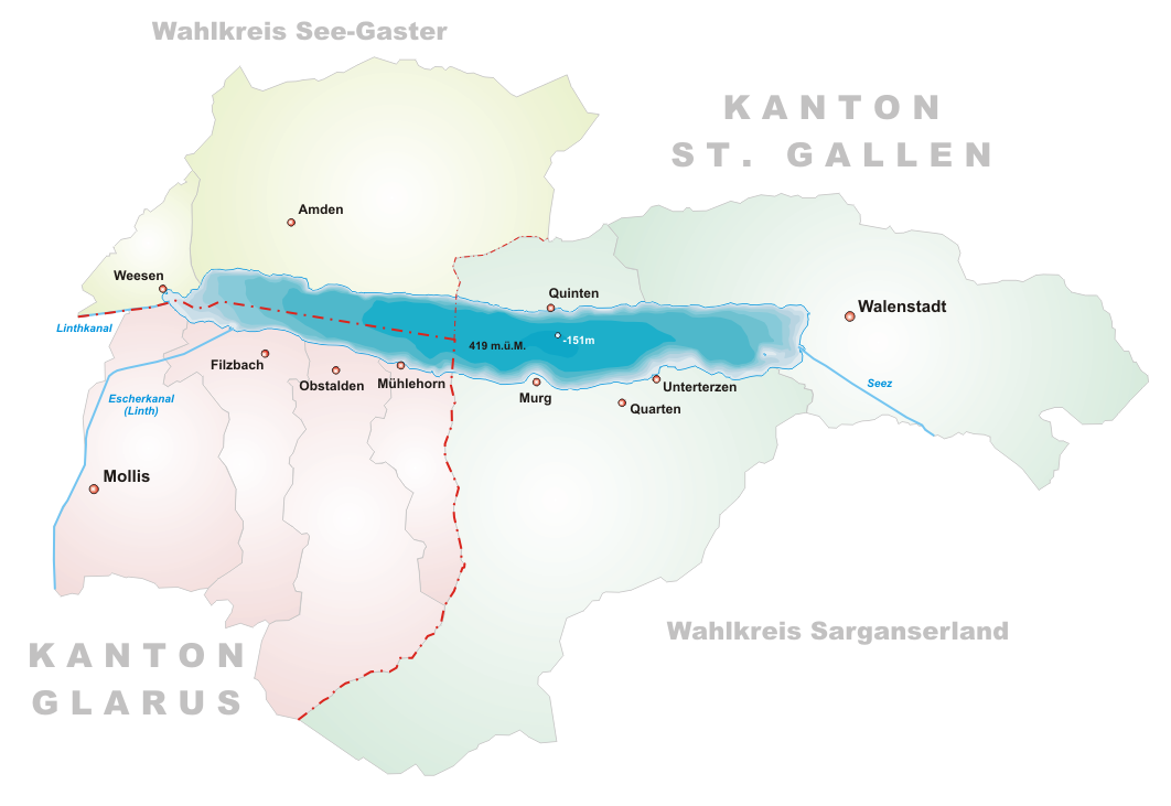


Physical characteristics and hydrology
Walensee receives water from several rivers and mountain streams and drains onward toward Lake Zurich. Principal inflows include the Seez, the Murgbach and the Linth, the last of which continues its course beyond Walensee toward lower valleys and eventually to Lake Zurich. The basin is relatively deep and fed by cold alpine runoff; steep valley walls restrict littoral zones and contribute to clear, cool lake waters.
Geology and formation
Walensee occupies a trough carved by Pleistocene glaciers and later shaped by fluvial erosion. The surrounding rock is largely limestone and other sedimentary units, and the Churfirsten range on the northern shore rises from the lake level to peaks that reach above 2,300 metres, creating dramatic vertical relief. This geology explains the steep cliffs, narrow shoreline corridors and a number of small talus slopes and scree fields visible from the water.
Towns, access and transport
Settlements cluster along the more accessible shorelines and in narrow bays. Notable towns and villages include Walenstadt, Weesen, Quarten, the hamlet of Quinten and Murg. These communities are linked by local roads and regional rail services that connect to larger Swiss transport networks. Passenger boats operate across the lake in season, providing both transport and scenic crossings; some smaller bays and hamlets are easier to reach by boat than by road.
Ecology and conservation
Ecologically, Walensee supports cold-water fish species and shore habitats adapted to steep slopes and limited littoral areas. Water quality is generally good, reflecting alpine inputs and local management, but shore development and nutrient inputs are monitored by canton authorities. Conservation in the catchment focuses on maintaining water quality, protecting vulnerable shoreline habitats and balancing tourism with natural values.
Recreation and tourism
The lake and surrounding mountains are popular for outdoor recreation. Activities include swimming in suitable, monitored spots during warm months, boating and scheduled ferry services, hiking on trails that ascend the Churfirsten or follow the shoreline, and climbing on exposed limestone faces. Quinten is notable for being little served by road and accessible to many visitors by boat and foot only; this contributes to its quiet character and vineyard terraces. Local visitor centres and canton tourism offices provide maps, seasonal timetables and information on routes and facilities.
Notable facts and visitor information
- Principal inflows: Seez, Murgbach, Linth.
- Shoreline communities: Walenstadt, Weesen, Quarten, Murg, Quinten.
- Administrative region: Canton of St. Gallen and Canton of Glarus.
- Island: the small Schnittlauchinsel at the eastern end.
- Mountain backdrop: the Churfirsten ridge rises steeply above the lake, with peaks exceeding 2,300 metres.
For visitors and students of alpine landscapes, Walensee offers a compact example of glacial topography, strong vertical relief and lakeshore communities that combine outdoor recreation with local traditions. Regional tourism offices and canton websites provide up-to-date information on transport, guided walks and conservation measures; for practical planning consult local timetables and trail maps.
Related articles
Author
AlegsaOnline.com Walensee (Lake Walen) — Alpine lake in eastern Switzerland Leandro Alegsa
URL: https://en.alegsaonline.com/art/106228