Santa Cruz River (Arizona–Sonora)
A transboundary river across southern Arizona and northern Sonora, the Santa Cruz River is a desert waterway with historical, ecological and cultural importance and ongoing restoration efforts.
The Santa Cruz River is a transboundary stream that runs through southern Arizona and northern Sonora, crossing the international line between the United States and Mexico. Its headwaters arise in the upland grasslands of the San Rafael Valley, east of the town of Patagonia, and the river follows a looping course: flowing south into Sonora, turning west, then reentering the U.S. near Nogales. From the border it continues north through a corridor of towns and historical sites toward the Santa Cruz Flats and the Gila River basin.
Image gallery
9 Images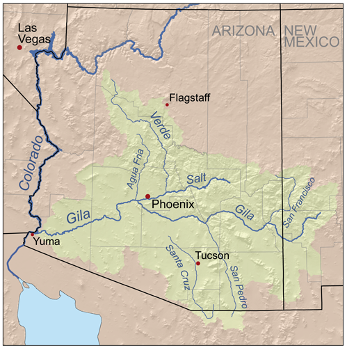


Characteristics and course
The Santa Cruz is a desert river whose behavior changes along its length. In higher-elevation reaches and perennial tributaries such as Sonoita Creek the flow can be reliable in wetter years, while long stretches through arid plains are intermittent or dry in many seasons. Urban effluent and managed recharge have created artificially perennial stretches near Tucson, producing visible flows where the river once ran only after rains. The river’s valley includes riparian woodlands, floodplain sediments, and a mosaic of cottonwood-willow galleries that contrast sharply with surrounding desert scrub.
Human history and cultural significance
Human use of the Santa Cruz corridor goes back millennia. Indigenous peoples, including the ancestors of the region’s modern O’odham and the prehistoric Hohokam cultural complex, developed irrigation and settlement systems along the river. During the Spanish colonial era mission communities were established along its banks; surviving historic complexes such as San Xavier del Bac and Tumacácori testify to that period. Towns and agricultural operations later grew around the river, drawing on its water for crops, livestock and domestic use.
Ecology and conservation
As a riparian corridor in the Sonoran Desert, the Santa Cruz supports plant and animal communities disproportionate to the surrounding aridity. Migratory birds, native fish in permanent pools, and mammals use the shaded river corridor for feeding and breeding. The 20th century brought declines in natural flows from groundwater pumping, channelization and land-use change. In recent decades, local governments, tribes and conservation groups have pursued restoration, bank stabilization, revegetation and managed aquifer recharge to recover habitat and reconnect fragmented reaches.
Uses, management and modern issues
- Water supply: municipal and agricultural pumping, treated effluent reuse, and recharge operations help sustain local communities.
- Cultural and recreational values: historical sites, birdwatching, walking trails and educational programs line parts of the river corridor.
- Binational governance: crossing an international border, the Santa Cruz watershed is affected by policy choices and cooperative efforts on both sides of the line, centered near Nogales and other border communities.
Notable places along the river
- San Rafael Valley and the Patagonia area, where the river originates.
- International border near Nogales, marking the river’s reentry to the U.S.
- Historic mission sites such as Tumacácori and San Xavier del Bac, and towns and communities including Green Valley, Tubac and Tucson.
Efforts to study, restore and adaptively manage the Santa Cruz continue, balancing urban needs, agricultural uses and the desire to preserve a functioning riparian ecosystem in a semi‑arid landscape. For regional context and planning information, see materials provided by local agencies and binational initiatives that address river health, recharge and flood management (Arizona resources), cross‑border coordination (Sonora resources), and municipal programs in the United States and Mexico.
Related articles
Author
AlegsaOnline.com Santa Cruz River (Arizona–Sonora) Leandro Alegsa
URL: https://en.alegsaonline.com/art/87121