Arizona: Geography, history, and significance of the Grand Canyon State
Comprehensive overview of Arizona: physical geography, climate, history, peoples, economy and notable features including the Grand Canyon, Four Corners, major cities and Native American nations.
Arizona is a U.S. state in the southwestern region of the country. It is commonly grouped with the Southwestern United States because of its climate, landscapes, and cultural history. The state shares borders with New Mexico to the east, Utah to the north, Nevada to the northwest, and California to the west. In the far northeast a single point meets Colorado at the Four Corners region, where Arizona touches that state at one corner, a place often noted for the Four Corners monument. To the south, Arizona borders the country of Mexico, forming an important international frontier.
Image gallery
10 Images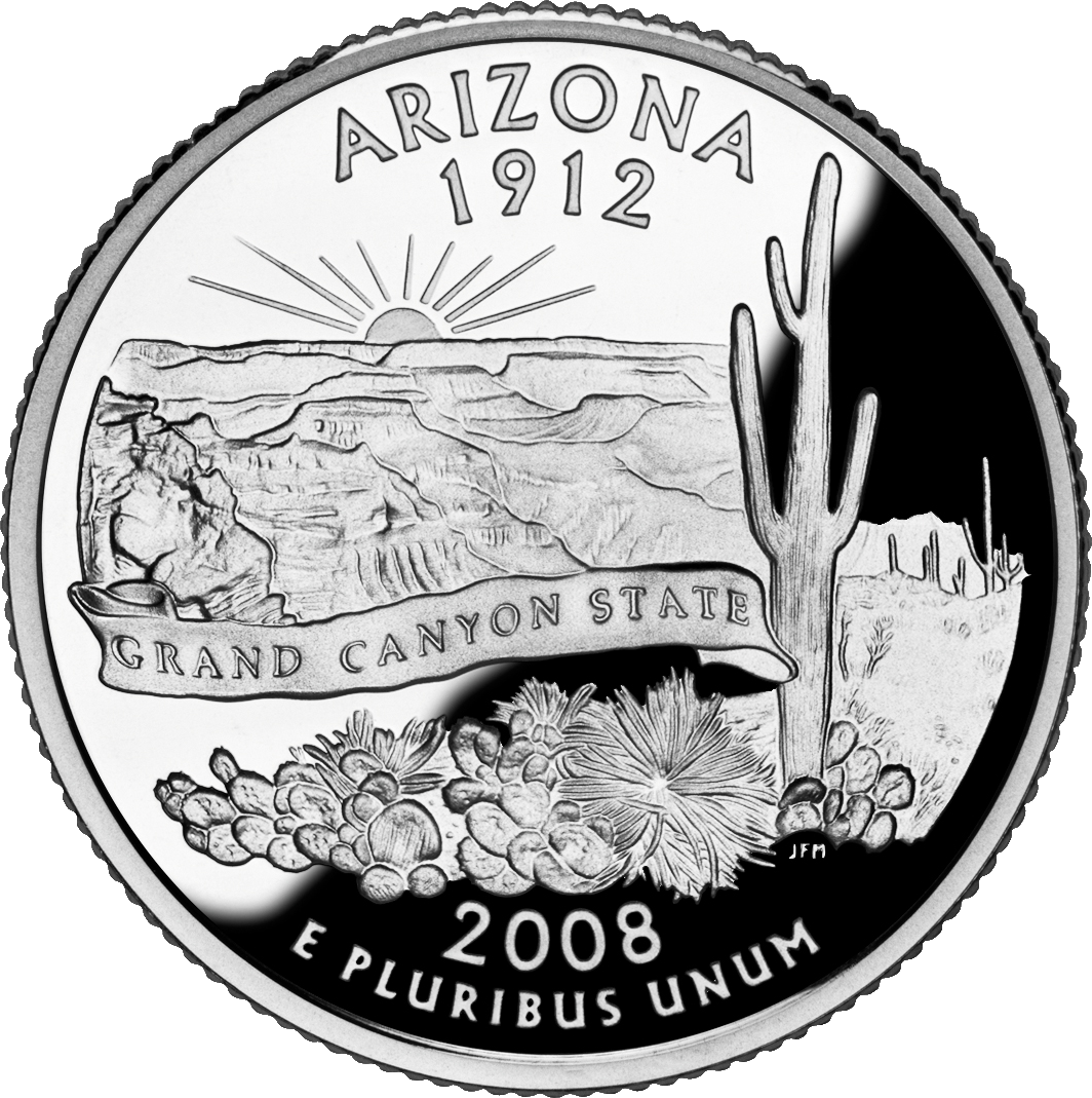


Geography and natural features
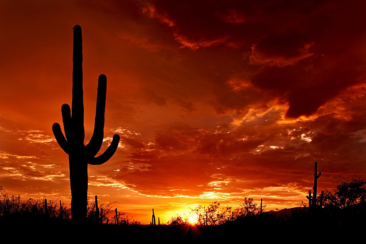
Arizona's terrain ranges from low desert basins to high plateaus and forested mountains. The Sonoran Desert covers much of the southwestern portion and supports unique plants such as the saguaro cactus. In the north, the Colorado Plateau and the Colorado River carved some of the state's most dramatic scenery, including the world-famous Grand Canyon. The state also contains significant mineral deposits and has a long history of copper mining, a reason for the nickname the Copper State. Major waterways, highland forests and riparian corridors provide contrasts to the hot desert lowlands.
Climate and environments
Arizona's climate varies with elevation. Low-lying cities and deserts experience very hot summers with prolonged heat, while higher elevations have milder summers and winter snowfall. For example, the capital and largest city, Phoenix, is notable for its hot summer temperatures. Northern communities on plateaus and mountain ranges can be cool and even skiable during winter months, creating a range of outdoor recreation opportunities.
People, cultures, and governance
Indigenous peoples have lived in the region for millennia; today Arizona is home to many Native American nations, including the Navajo (Diné), Hopi and Tohono O'odham. The state recognizes numerous tribes and reservations, and Native cultures remain an important part of Arizona's cultural fabric. European contact brought Spanish exploration and later Mexican governance before the area became part of the United States. Arizona's path to statehood concluded on February 14, 1912, when it became the 48th state.
Economy, cities and land use
Arizona's economy mixes mining (notably copper), agriculture, tourism and service industries. The Grand Canyon and other natural attractions draw millions of visitors each year, making tourism a major economic component. Agricultural production—especially in irrigated river valleys—supplies winter vegetables and other crops. Urban growth is concentrated in the Phoenix metropolitan area, which is one of the largest metropolitan regions in the country and hosts major commercial, cultural and educational institutions.
Important facts and distinctions
- Nicknames: the Grand Canyon State and the Copper State.
- Bordering jurisdictions: New Mexico, Utah, Nevada, California, and at a single point Colorado (Four Corners).
- International border with Mexico, important for trade, migration and cross-border communities.
- Historic landmarks and modern infrastructure include the Grand Canyon, parts of the Colorado River system, and significant mining regions linked to the state's mineral deposits and extractive history.
Arizona's mixture of desert and mountain landscapes, deep Indigenous and frontier histories, and its economic roles in mining, tourism and agriculture make it a geographically and culturally diverse state. Cities, rural towns, national parks and tribal lands each contribute to the state's identity. For further reading about specific topics—geography, Native nations, or tourism—see regional guides and official resources for conservation, heritage and travel planning at resources such as regional overviews, state portals and tribal websites. Additional authoritative materials and maps are commonly available through educational institutions and public land agencies referenced in many summaries (regional maps, climate summaries, resource guides, transportation, legal boundaries, mineral reports, climate data, and temperature records).
For general orientation: look for maps and visitor information at park and tourism sites (Phoenix area guides and Grand Canyon resources), and consult tribal authorities for culturally appropriate information about Indigenous lands and communities (mineral history, Four Corners, state services, monument information, and border region guidance).
Geography
Throughout the south, Arizona borders Mexico. Otherwise, the border is internal. To the southwest it borders California, to the northwest Nevada. To the north, the border with Utah runs toward Four Corners' Point, the only four-county point in the United States and one of the few in the world. There, Arizona meets Colorado in the far northeast and shares its eastern border entirely with New Mexico.
Arizona belongs to two natural areas. The northeastern part of the state lies on the Colorado Plateau, all other parts of Arizona belong to the Basin and Range region. The border is formed by the Mogollon Rim mountain range.
The Colorado River and the Grand Canyon it forms separate the Arizona Strip from the rest of the state in the northwest. It also forms almost all of Arizona's western border with Nevada and California. Other major rivers in Arizona include the Little Colorado River in the northeastern part of the state and the Gila River and its tributaries in central and southern Arizona.
Structure
See also: List of counties in Arizona
The US state of Arizona is divided into 15 counties, which have an average area of 19,683.6 km².
Climate
Arizona has a dry desert and semi-desert climate, in the north rather steppe climate. This leads to relatively mild winters and hot summers, depending on the altitude. Because of the proximity to the Rocky Mountains, there are usually large temperature differences between day and night. Average rainfall ranges from about 100 to 500 mm per year, with most of the rain falling from July to November. Furthermore, the city of Yuma is one of the sunniest places in the world, with around 4000 hours of sunshine annually. On the other hand, the city of Flagstaff, located at around 2135 meters in the north of the state, is one of the most important winter sports resorts in the United States.
| Monthly average temperatures (max/min) for selected locations in Arizona | ||
| Location | July (°C) | December (°C) |
| 41/28 | 19/7 | |
| 38/23 | 18/4 | |
| 41/28 | 20/8 | |
| 27/11 | 5/−8 | |
| 31/15 | 11/−4 | |
| 36/19 | 13/0 | |
flora and fauna
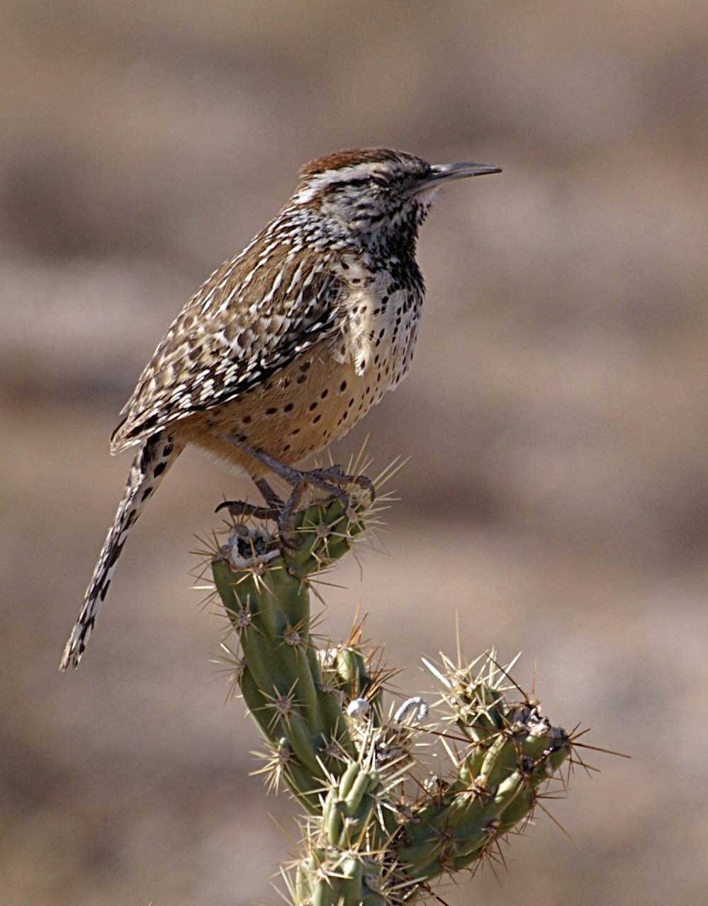
Because of the drought, Arizona grows many cacti, palm lilies and mesquite trees. The largest wildlife species include white-tailed and mule deer, as well as wapiti, pronghorn and bighorn sheep. Scattered bears still live in remote areas. Predators such as cougars, jaguars, badgers, and other marten-like animals live in the mountainous regions. In the Sonoran Desert there are many species of lizards, spiders and snakes.
Population
| Population development | |||
| Census | Inhabitants | ± in % | |
| 1900 | 122.931 | - — | |
| 1910 | 204.354 | 66,2 % | |
| 1920 | 334.162 | 63,5 % | |
| 1930 | 435.573 | 30,3 % | |
| 1940 | 499.261 | 14,6 % | |
| 1950 | 749.587 | 50,1 % | |
| 1960 | 1.302.161 | 73,7 % | |
| 1970 | 1.770.900 | 36 % | |
| 1980 | 2.718.215 | 53,5 % | |
| 1990 | 3.665.228 | 34,8 % | |
| 2000 | 5.130.632 | 40 % | |
| 2010 | 6.413.158 | 25 % | |
| Estimate 2011 | 6.482.505 | 1,1 % | |
| Before 1900 1900–1990 2000 | |||
Arizona is home to 6,392,017 people (as of the 2010 Census), 76.9% of whom are White, 4.5% Native American, 3.4% Black or African American, and 2.3% Asian American. 29.2% identify themselves as Hispanics or Latinos regardless of "race".
Ancestry
The most common ancestries of Arizona's population in 2009 were Mexican (27.4%), German (16%), Irish (10.8%), English (10.1%), and Italian (4.6%). The southern and central counties in particular are primarily Mexican, while the northern counties are largely populated by descendants of British immigrants, and the northeast has the largest percentage of Native American residents.
Since 2003, the Hispanic (Latino) population has given birth to more children than the non-Hispanic population, and Latinos are expected to be the majority of the population by 2035.
Languages
In 2000, 74.1% of the population had English as their first language, 19.5% Spanish, 1.9% Navajo, 0.6% other Native American languages, and 0.5% German. English has been the official language of the state since 2006.
Worldviews
The religious denominations with the most members in 2000 were the Catholic Church with 974,883, the Church of Jesus Christ of Latter-day Saints with 251,974, and the Southern Baptist Convention with 138,516 adherents.
Four-fifths of Arizona's population describes itself as Christian, with Catholics and Protestants strongly represented, and Mormons also making up a non-negligible portion.
- Christians: 80
- all Protestant churches together: 42
- Catholics: 31 %
- Mormons: 6 %
- other Christian denominations: 1 %
- other religions: 2 %
- non-religious: 18 %
Largest cities
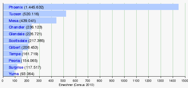
The cities of Phoenix, Mesa, Glendale, Gilbert, Chandler, Scottsdale, and Tempe merge almost seamlessly, so that the Phoenix-Mesa Metropolitan Area is often perceived as a single entity, even though they are administratively separate.
- List of cities in Arizona


Questions and answers
Q: What is Arizona?
A: Arizona is a state in the United States of America, considered part of the Southwestern United States.
Q: What states border Arizona?
A: New Mexico to the east, Utah to the north, Nevada to the northwest, and California to the west. Its northeast corner touches part of Colorado.
Q: Which country borders Arizona to the south?
A: Mexico shares a border with Arizona to the south, a distance of 389 miles (626 km).
Q: What are some nicknames for Arizona?
A: Arizona is called the "Grand Canyon State" and the "Copper State".
Q: When did Arizona become a state?
A: Arizona became a state on February 14th, 1912, and was the 48th state accepted into the United States.
Q: What is the capital city of Arizona?
A: Phoenix is the capital city of Arizona and is also the largest city in the state. It is the largest capital city in the US.
Q: What is the climate like in Arizona?
A: Arizona's climate can be very hot, with an average temperature of about 107 degrees Fahrenheit (42 degrees Celsius) in summer in Phoenix.
Related articles
Author
AlegsaOnline.com Arizona: Geography, history, and significance of the Grand Canyon State Leandro Alegsa
URL: https://en.alegsaonline.com/art/5585
Sources
- commons.wikimedia.org : Arizona
- census.gov : "Arizona: Population estimates"
- kff.org : "Median Annual Household Income"
- hardwoodforest.org : "Hardwood Forest Foundation: Experience: Arizona"
- ncsu.edu : "Prescott Overview"
- azsos.gov : Kids' Page - Arizona State Songs