Panhandle (geography): narrow territorial projections and examples
A panhandle is a narrow projection of territory attached to a larger area on only one side. This article explains its form, causes, examples, and why such regions matter.
Overview
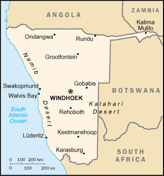
In geography the term "panhandle" describes a slender extension of land that connects to the main body of a state, province, or country on only one side. The name alludes to the handle of a frying pan: a long, thin appendage attached to a broader area. Panhandles are bounded on most sides by other political units, water or international borders, while remaining administered by the parent territory.
Image gallery
2 Images
Typical characteristics
Panhandles vary in length, width and landscape, but share a few common features. They are physically contiguous with the parent territory yet often separated socially, economically or ecologically from it. A panhandle may be surrounded by one or several neighboring countries or internal regions. Because of their shape, panhandles can create transportation bottlenecks, jurisdictional complexities, and distinctive local identities.
How panhandles form
Several processes can produce a panhandle. Historical treaties, colonial-era border drawing, river courses, land purchases, and surveying errors have all contributed. Political compromises sometimes leave narrow corridors to provide a state or country access to particular resources, ports or to satisfy settlement patterns. Over time, these pragmatic decisions become permanent features of maps.
Notable examples
- Florida Panhandle — the northwestern strip of the U.S. state of Florida along the Gulf of Mexico.
- Oklahoma Panhandle — the short, western extension of Oklahoma between Texas and Kansas.
- Alaska Panhandle — the southeastern coastal corridor of Alaska, a string of islands and mainland coast with access to the Pacific.
- Other well-known panhandles include the Texas Panhandle and international examples where borders produce similar shapes.
Importance and distinctions
Panhandles can matter disproportionately to administration, transport and culture. They may host border crossings, unique ecosystems, or communities that feel more connected to adjacent regions than to the governing center. In cartography and political geography, panhandles are related to terms like "salient" (a projecting piece of territory) and distinct from exclaves, which are entirely separated from their parent territory.
Implications and study
Scholars study panhandles to understand how borders affect economics, identity and governance. Practical concerns include road and utility access, emergency services reach, and policy tailored to local needs. For readers interested in maps and border history, panhandles provide clear examples of how human decisions shape the contours of political space and everyday life.
For general background on border forms see the frying-pan analogy and related discussions; for more region-specific information consult resources linked for particular examples above.
Related articles
Author
AlegsaOnline.com Panhandle (geography): narrow territorial projections and examples Leandro Alegsa
URL: https://en.alegsaonline.com/art/74365