OpenStreetMap — the collaborative open geographic database
OpenStreetMap (OSM) is a community-built, editable map and open database of geographic information for the world, used for navigation, research, humanitarian response and many apps.
Overview
OpenStreetMap (OSM) is a global, editable map and underlying geographic database created and maintained by a volunteer community. It provides vector map data and derived map imagery that anyone can view, edit and reuse under open terms. The project emphasizes local knowledge and crowd-sourced contributions to build a detailed representation of streets, paths, points of interest, land use and more.
Image gallery
10 Images


Data model and sources
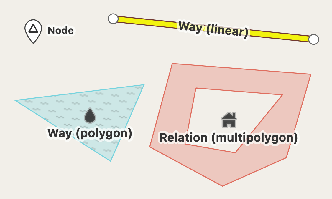
OSM stores geographic information as simple primitives—nodes, ways and relations—combined with descriptive tags. Contributors add data from a variety of sources: handheld GPS traces, aerial and satellite imagery, local surveys, official public-domain datasets and community memory. The result is downloadable vector data suited for routing, analysis and map rendering; some rendered raster tiles are also available for browsing and embedding. For official downloads and mirrors see the project website: OpenStreetMap site.
Editing tools and workflows
Editing can be done in-browser or with desktop editors. Common tools include simple web editors for beginners and more advanced offline editors for power users. Edits are reviewed through changelogs and community discussion; mapping events and organized imports help improve coverage in under-mapped areas. Beginners find gateways and tutorials on the main site while advanced contributors use validation tools and plugins.
History and governance
OSM began as a grassroots mapping effort and has since grown into a worldwide community supported by the OpenStreetMap Foundation, a non-profit that coordinates infrastructure, events and legal stewardship. Community members organize mapping parties, humanitarian mapping drives and regional chapters to improve data in their localities and respond to crises.
Licensing and reuse
The raw geographic database is distributed under an open database license to preserve free reuse, while various rendered map tiles and creative outputs may carry share-alike or attribution requirements. Users should consult the specific license for any dataset or tile service before reuse: database downloads and licensing details are available via the project download pages (database license), and many rendered tile sets reference Creative Commons or similar terms (tile license).
Uses and examples
OpenStreetMap data is used across sectors: navigation and routing apps, humanitarian response and disaster mapping, academic research, urban planning, and embedded systems. Because the data is open, developers and organizations can adapt it for offline maps, custom styling, and integration with other open datasets. For technical resources about vector formats and downloads see the project documentation: vector data resources and regional download portals (global downloads).
Notable distinctions
- OSM is community-driven rather than centrally produced by a corporation.
- Its open database model encourages reuse, corrections and local detail often missing from proprietary maps.
- Contribution scales from single edits to organized imports and humanitarian mapping campaigns.
For more information, documentation and how to start contributing, consult the official pages and community guides linked above or join a local mapping group to learn practical techniques.
Related articles
Author
AlegsaOnline.com OpenStreetMap — the collaborative open geographic database Leandro Alegsa
URL: https://en.alegsaonline.com/art/72790
Sources
- github.com : "OpenStreetMap.org Github"
- wiki.openstreetmap.org : "FAQ"
- alexa.com : "Openstreetmap.org Traffic, Demographics and Competitors - Alexa"
- openstreetmap.org : "OpenStreetMap stats report"
- wiki.openstreetmap.org : "OpenStreetMap Wiki - History of OpenStreetMap"
- blog.osmfoundation.org : "OpenStreetMap data license is ODbL v1.0"