Isle (river) — a right-bank tributary of the Dordogne in southwestern France
The Isle is a river in southwestern France (Occitan: Eila) flowing through Haute-Vienne, Dordogne and Gironde in Nouvelle-Aquitaine and joining the Dordogne River as a right-bank tributary.
Overview
The Isle (Occitan: Eila) is a river in southwestern France. Its course begins in the eastern part of the Nouvelle-Aquitaine region and it runs generally westward through the departments of Haute-Vienne, Dordogne and Gironde before joining the Dordogne River as a right tributary. The river’s approximate location is noted by its coordinates (44°54′56″N 0°14′56″W).
Image gallery
8 Images


Course and towns
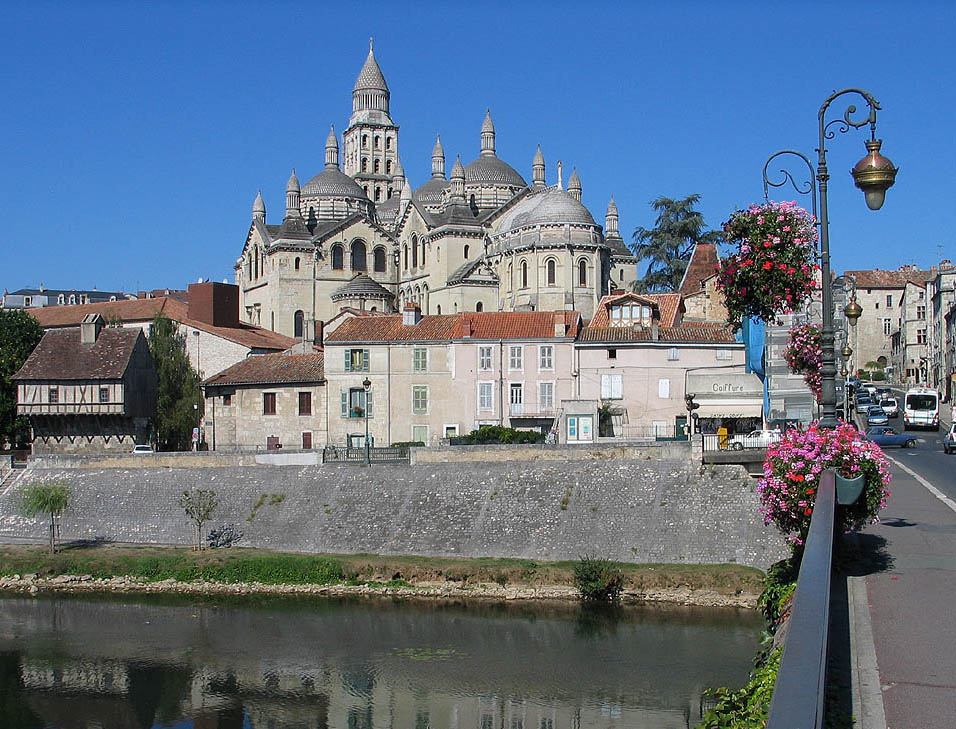
The Isle rises in the uplands of Haute-Vienne and flows across a mix of rural and urban landscapes. On its path it passes through or near several Dordogne towns and communes, most notably the city of Périgueux, which developed historically along the river valley. From the Dordogne department the Isle continues westward and ultimately meets the Dordogne River within the Gironde départemental area, contributing to the larger Dordogne–Gironde fluvial system that drains to the Atlantic.
Characteristics
The Isle drains a basin of moderate size for the region and is fed by numerous small tributaries and seasonal streams. Its flow regime reflects the temperate Atlantic climate of southwest France, with higher discharges in the wetter months and lower flows in late summer. In its lower reaches the river traverses wider floodplains and meanders, while upper reaches are narrower and more confined.
History and human use
The river valley has supported human settlement for centuries. Towns along the Isle made use of the watercourse for freshwater supply, milling, agriculture and local transport. Périgueux, with Roman and medieval roots, owes part of its development to its situation on the river. In more recent centuries, the Isle’s waters have been used for irrigation, small-scale industry and recreational activities such as angling and boating.
Ecology and conservation
Riverine habitats on the Isle support a range of freshwater species and riparian flora. Wetlands and floodplain habitats associated with the Isle are important for birds and amphibians. Like many European rivers, the Isle faces pressures from diffuse pollution, water abstraction and habitat modification; regional authorities and conservation groups in Nouvelle-Aquitaine and local departments (see regional initiatives) monitor water quality and seek measures to restore ecological continuity and biodiversity.
Notable facts and connections
- The Isle is known locally by its Occitan name, Eila (source).
- It is a tributary of the Dordogne, one of southwest France’s principal rivers, which eventually contributes to the Gironde estuary.
- Coordinates and mapping references for the river are commonly provided for navigation and study (coordinates).
Questions and answers
Q: What are the coordinates of The Isle river?
A: The coordinates of The Isle river are 44°54′56″N 0°14′56″W / 44.91556°N 0.24889°W / 44.91556; -0.24889.
Q: Where does The Isle river flow through?
A: The Isle river flows through the Haute-Vienne, Dordogne and Gironde departments, in the Nouvelle-Aquitaine region of south-western France.
Q: Is The Isle river a left or right tributary of the Dordogne river?
A: The Isle river is a right tributary of the Dordogne river.
Q: What is the Occitan name for The Isle river?
A: The Occitan name for The Isle river is Eila.
Q: In what region of France is The Isle river located?
A: The Isle river is located in the Nouvelle-Aquitaine region of south-western France.
Q: Through how many departments does The Isle river flow through?
A: The Isle river flows through three departments - Haute-Vienne, Dordogne, and Gironde.
Q: What kind of river is The Isle?
A: The Isle river is a right tributary of the Dordogne river.
Related articles
Author
AlegsaOnline.com Isle (river) — a right-bank tributary of the Dordogne in southwestern France Leandro Alegsa
URL: https://en.alegsaonline.com/art/48443
Sources
- services.sandre.eaufrance.fr : "L'Isle (P---0150)"
- hydro.eaufrance.fr : "L'Isle à Coutras"
- geoportail.gouv.fr : "Source de l'Isle"
- geoportail.gouv.fr : "Confluence de l'Isle"
- services.sandre.eaufrance.fr : "La Loue (P61-0400)"
- services.sandre.eaufrance.fr : "L'Auvézère (P6--0250)"
- services.sandre.eaufrance.fr : "La Dronne (P7--0250)"
- services.sandre.eaufrance.fr : "Le Lary (P80-0400)"