Hudson Strait: the Arctic channel between the Atlantic and Hudson Bay
Hudson Strait is the marine passage between Baffin Island and northern Quebec that links the Atlantic Ocean to Hudson Bay. It is a long, ice-affected route with strong tides, historical significance, and ecological importance.
Overview
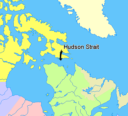
Hudson Strait is the broad channel that connects the open Atlantic Ocean to Hudson Bay, forming a principal seaway into the interior waters of northern Canada. Located between Baffin Island to the north and the mainland of the northern coast of Quebec to the south, the strait stretches roughly 450 miles (about 720 km) from its eastern to western approaches. Its width varies widely, narrowing at points to around 40 miles (64 km) and expanding in places to approximately 150 miles (240 km).
Image gallery
3 Images

Physical characteristics
The eastern entrance is framed by Cape Chidley and Resolution Island. The strait links sub-Arctic and Arctic waters with the North Atlantic, producing strong tidal flows and complex currents. Seasonal sea ice and pack ice dominate much of the year, while storm-driven seas can create hazardous conditions for navigation. Depths vary along the channel, and the mix of islands, shoals and tidal rips has historically challenged mariners.
- Length: about 450 miles / 720 km.
- Width: from roughly 40 to 150 miles (64–240 km).
- Entrances: east between Cape Chidley and Resolution Island; west opening into Hudson Bay.
- Climate: Arctic–subarctic, with heavy ice cover in winter and spring.
History and human use
European knowledge of the strait dates to the early 17th century when the English navigator Henry Hudson sailed into the area in 1609. Early explorers and traders initially hoped these waters might form part of the fabled Northwest Passage, a continuous route linking the Atlantic and Pacific. While the strait is not the Northwest Passage, its discovery opened access to the vast northern interior and played a decisive role in the era of Arctic exploration and the development of fur trade routes.
Ecology, communities and modern significance
The strait supports a range of Arctic marine life—seabirds, seals, and migratory fish—and is an important corridor for whales and ice-associated species. Coastal areas are sparsely populated by Indigenous communities that have long depended on marine resources; those settlements lie along the adjacent shores of Baffin Island and the Labrador–Quebec coast. In modern times the waterway remains important for seasonal shipping to northern ports, for scientific research into Arctic oceanography and climate, and for resource access during ice-reduced months.
Navigation and contemporary issues
Navigation through Hudson Strait demands careful planning because of tides, ice, and rapidly changing weather. Climate change has altered ice seasonality, extending open-water periods in some years and raising new questions about shipping, environmental risk, and the resilience of local communities and ecosystems. The strait continues to be monitored for its strategic, commercial and ecological roles in the broader Arctic region.
For more technical details, charts and contemporary guidance consult hydrographic authorities and regional sources for navigation and marine research (Atlantic Ocean resources and local Canadian publications via Canada-focused portals).
Related articles
Author
AlegsaOnline.com Hudson Strait: the Arctic channel between the Atlantic and Hudson Bay Leandro Alegsa
URL: https://en.alegsaonline.com/art/45551
Sources
- books.google.com : The Hudson Bay road (1498-1915)
- answers.com : answers.com
- tools.wmflabs.org : 62°29′36″N 071°57′43″W / 62.49333°N 71.96194°W / 62.49333; -71.96194 (Hudson Strait)