Ermine Street: Roman road from Londinium to Eboracum
Ermine Street was a principal Roman road linking London with Lincoln and York. Its original Roman name is unknown; its route influenced modern highways and survives in archaeology and place names.
Overview
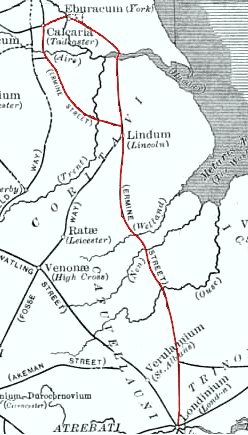
Ermine Street was one of the principal Roman roads in Britain, running broadly north from the provincial capital at Londinium (modern London) to Lindum Colonia (Lincoln) and onward to Eboracum (York). Built and maintained under Roman administration, the road carried troops, official couriers, commercial traffic and facilitated administration across the province. The original Roman designation for the route is not recorded in surviving sources; the English name "Ermine Street" is medieval in origin and has been applied to the principal northbound alignment from London.
Image gallery
3 Images

Route and alignment
The course of Ermine Street is reconstructed through a combination of surviving earthworks, place-name evidence, historic maps and archaeological excavation. It crosses a variety of landscapes and remains visible in places as a remarkably straight alignment, typical of Roman road planning. From the London area it continues north through territory that today lies within Greater London and the counties to the north and east, passing close to several modern towns and surviving as sections of later highways. The southern part of the route is often referred to as the Old North Road where it follows the long-established medieval track out of London to the north and joins later trunk roads such as the A1.
Construction and maintenance
Roman roads like Ermine Street were engineered for durability and drainage. Typical features included a raised agger or roadbank, a layered foundation of compacted materials, and a wearing surface of gravel, cobbles or paving stones where local conditions and traffic warranted. Flanking ditches controlled surface water, and the carriageway width and construction varied with importance and intended use. The Roman administration regularly maintained principal routes to ensure reliable movement of troops and communications between military sites and towns.
Crossings and alternative routings
Where natural barriers existed the Romans adapted by rerouting, building engineered crossings where feasible, or using river transport. The Humber estuary presented a major obstacle on the eastern portion of the island. The Humber is the wide tidal mouth formed by the Rivers Trent and Ouse, and its breadth and tidal conditions made a permanent bridge impracticable at the location where the most direct line would cross. As a result, traffic sometimes followed an alternative inland route to avoid hazardous tidal stretches, and river crossings by boat or ferry are commonly inferred for places where a direct track approached the estuary. The tidal nature of such waters is an important factor in reconstructing Roman itineraries and seasonal movement of goods and people (tidal estuaries).
Archaeological evidence
Evidence for Ermine Street comes from milestones, road surfaces uncovered in excavation, roadside settlements, and the pattern of later settlement that often follows the Roman alignment. Milestones and place names can help confirm the course and indicate distances used in Roman administration. Archaeological survey methods include fieldwalking, geophysical survey, aerial photography and targeted excavation; these techniques continue to refine the known route and reveal local variation in construction and use.
Legacy and modern traces
The route of Ermine Street has left a lasting imprint on the landscape. In many areas medieval and later roads overlay the Roman line, and some modern A-roads and local highways still occupy stretches of the ancient alignment. Where the Roman agger survives as an earthwork it is a feature of archaeological and environmental interest. Local museums and heritage organisations interpret finds from along the corridor, and regional studies provide guides to surviving sections and places where the road can be traced on the ground or in maps (Roman roads in Britain, London).
Research, conservation and visiting
Study of Ermine Street is ongoing. Researchers draw on documentary sources, place-name evidence, landscape archaeology and targeted excavations to clarify uncertainties about alignment, construction and chronology. Conservation and responsible access are priorities where earthworks and paved remains survive, and many local heritage bodies provide information for visitors. For those interested in environmental and hydrological context of river crossings and estuaries related to the route, specialist resources examine the Humber and its tributaries such as the Humber and wider river systems. Locality-focused publications and regional conservation groups remain the best route to up-to-date information about particular stretches, and readers are encouraged to consult local authorities and heritage organisations for visitor guidance (York, Godmanchester).
Although the broad course and significance of Ermine Street are well established, details such as the road's original Roman name and some precise alignments in built-up or heavily altered areas remain subjects for further research. The road exemplifies how Roman transport infrastructure shaped patterns of movement and settlement in Britain for many centuries and continues to be an important focus for archaeological and historical study.
Related articles
Author
AlegsaOnline.com Ermine Street: Roman road from Londinium to Eboracum Leandro Alegsa
URL: https://en.alegsaonline.com/art/31984