River Humber — the estuary of northeastern England
The River Humber is a large deep-water estuary on England's east coast, formed by the Ouse and Trent. It is a major navigation route, ecological zone and historic boundary between counties.
The River Humber is a broad, deep-water estuary on the east coast of England. It is created where the River Ouse and the River Trent meet and flow east into the North Sea. The Humber functions as a tidal channel, a shipping approach for inland ports, and an important natural habitat along roughly 40 miles from the confluence to the sea. For context on its classification, see estuary descriptions and regional references for Northern England.
Image gallery
5 Images


Key characteristics
The Humber is notable for its width, depth and strong tidal currents. Its principal feeders are the Rivers Ouse and Trent; together they drain a large hinterland of central and northern England. The confluence of those rivers is a defining feature: River Ouse and River Trent join to form the estuary, which then opens to the North Sea. The estuary separates the East Riding of Yorkshire to the north and Lincolnshire to the south, acting as a county boundary in places (East Riding of Yorkshire, Lincolnshire).
History and human use
Human activity on the Humber has long centered on navigation, trade and fishing. The wide channel and deep water have supported ports and docks for centuries; settlements such as Kingston upon Hull and nearby fishing and cargo towns grew around access to the estuary. The need to cross the water led to ferries and paddle steamers before the construction of the modern fixed link.
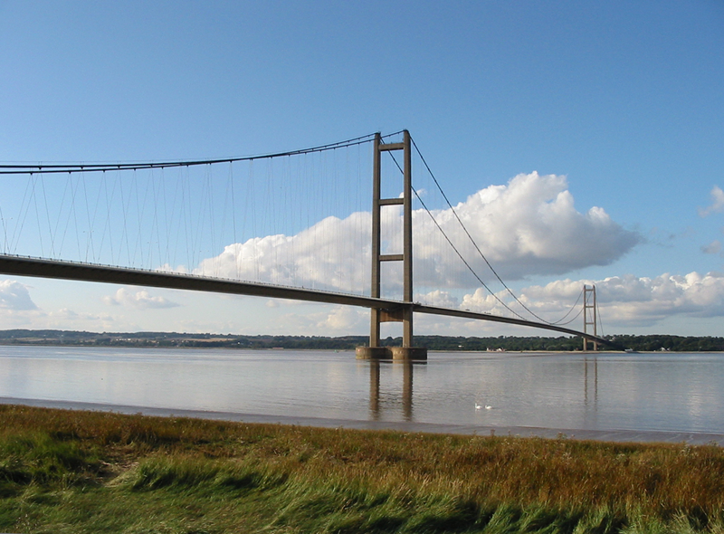
The principal modern crossing is the Humber Bridge, opened in 1981. At the time it was the longest single-span suspension bridge in the world and remains one of the most notable engineering landmarks on the estuary — readers can find technical and historical summaries at resources about the Humber Bridge. Before the bridge, passenger and vehicle ferries were routine across the mile-wide channel.
Uses, ecology and importance
Today the Humber continues to be important for commercial shipping, energy infrastructure and wildlife. Major ports handle cargo and fishing fleets, while estuarine habitats—mudflats, sandbanks and saltmarsh—support migratory birds, nursery grounds for fish and coastal biodiversity. The combination of industrial activity and protected natural areas makes the Humber region a focus for conservation as well as commerce.
Notable facts
- The Humber is the tidal estuary formed by the meeting of two principal rivers; its channel leads east to the sea over a distance of about 40 miles.
- It serves as a local administrative boundary between the East Riding of Yorkshire and Lincolnshire.
- Transport across the estuary evolved from ferries and paddle steamers to the modern Humber Bridge, an internationally recognised suspension bridge.
For further reading and maps consult regional navigation guides, ecological surveys and local histories linked in specialized resources (estuary guide, regional overview, tributary rivers, marine connections, northern bank county, southern bank county, bridge history).
Questions and answers
Q: Where is the River Humber located?
A: The River Humber is located on the east coast of Northern England.
Q: How is the River Humber formed?
A: The River Humber is formed by the River Ouse and the River Trent coming together.
Q: What is the length of the River Humber from its meeting point to the North Sea?
A: The length of the River Humber from its meeting point to the North Sea is about 40 miles.
Q: What are the areas that the River Humber forms part of the border between?
A: The River Humber forms part of the border between the East Riding of Yorkshire on the north side and Lincolnshire on the south side.
Q: What is the name of the only modern crossing on the River Humber and when was it built?
A: The only modern crossing on the River Humber is the Humber Bridge, which was built in 1981.
Q: What was used to cross the River Humber before the Humber Bridge was built?
A: Before the Humber Bridge was built in 1981, paddle steamers were used to cross the mile long span.
Q: What is the current ranking of the Humber Bridge in the list of longest single-span suspension bridges in the world?
A: The Humber Bridge is currently ranked as the fifth longest single-span suspension bridge in the world.
Related articles
Author
AlegsaOnline.com River Humber — the estuary of northeastern England Leandro Alegsa
URL: https://en.alegsaonline.com/art/83109