River Trent: course, history, ecology and significance
Overview of the River Trent in England: its course from Staffordshire to the Humber, name origin, hydrology, ecology, navigation, flood management and cultural importance.
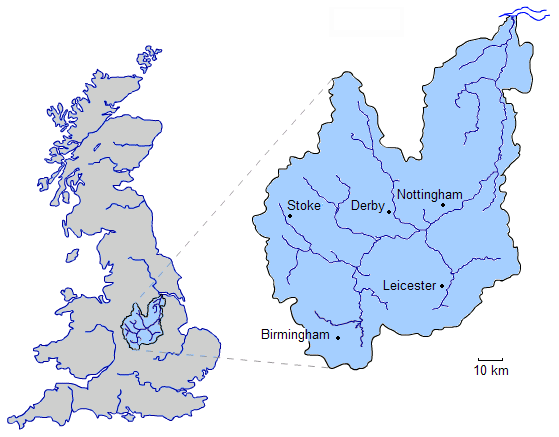
The River Trent is one of England's principal rivers, rising on high ground in Staffordshire and flowing east and north to join the River Ouse and form the Humber estuary, which opens into the North Sea. It is commonly described as the third-longest river in the United Kingdom and drains a large portion of the English Midlands. Over centuries the Trent has shaped landscapes, supported industry and transport, and influenced settlement patterns across central England. The river remains important for biodiversity, recreation and flood management.
Image gallery
3 Images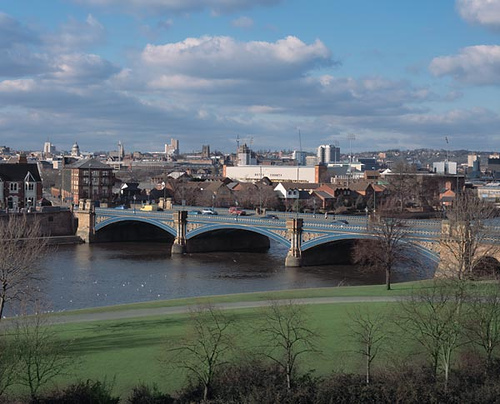

Course and tributaries
The Trent begins in upland moor and pasture country, where small streams coalesce to form a defined channel. From its upper reaches the river flows through or close to counties such as Staffordshire, Derbyshire, Nottinghamshire and Lincolnshire before reaching the estuary. Along its route it receives water from numerous tributaries, including rivers that rise on surrounding hills and plateaux and contribute to the Trent's seasonal flow. The river changes character downstream from steeper, faster upper reaches to broader, meandering lowland floodplain as it approaches the Humber.
Name, origins and human history
The name "Trent" is of ancient origin and is usually linked to a Celtic word or words that imply strong flooding or an "over-way," reflecting how the river can rise rapidly. Archaeological and historical evidence shows human use of the Trent valley for mill sites, transport and settlement since prehistoric and Roman times. In the medieval and early modern eras the river formed administrative boundaries in places and supported local economies through fisheries, milling and trade.
Hydrology, tidal influence and the Aegir
Hydrologically the Trent displays a mix of groundwater-fed and surface runoff behaviour. In its lower reaches the influence of tides from the Humber can be felt, and in some conditions a tidal bore, locally known as the "Aegir," can travel upstream against the river flow. Tidal action affects channel form, sedimentation and flood risk in downstream reaches; freshwater flow, tides and seasonal rainfall together govern water levels throughout the system.
Ecology and conservation
The Trent and its floodplain support a mosaic of habitats including wet woodland, marsh, reedbeds and neutral grasslands. These environments are important for birds, aquatic invertebrates and fish, and they provide corridors for wildlife movement across the Midlands. Water quality and connectivity have been the focus of restoration work in recent decades: measures such as re-meandering, improved fish passage and catchment-sensitive farming aim to benefit biodiversity while supporting sustainable land use.
Navigation, canals and industry
The Trent has long been used for transport. Improvements to navigation in the post-medieval period and the later construction of canals, notably the canal systems linked to the Trent, helped integrate river and inland waterway transport. Historically the river carried agricultural produce, coal and manufactured goods to ports on the Humber and beyond. Today several stretches remain navigable for leisure craft and river services, and the river corridor continues to host a mix of industrial, commercial and recreational activity.
Flood risk and management
Flooding is a natural feature of the Trent's floodplain. Over time a combination of engineered defences—embankments, sluices and bypass channels—and designated washlands has been developed to reduce risk to towns and farmland. Catchment-scale planning by national and local agencies, community groups and landowners aims to combine hard defences with natural flood management techniques such as restoring wetland storage, to reduce peak flows and improve resilience to extreme weather.
Cultural and regional significance
As a major river of England, the Trent has a presence in regional identity, place names and the built environment. Towns and cities near the river grew in response to its resources and transport opportunities. The Trent basin continues to be an area of economic activity as well as a focus for conservation and recreation; riverside trails, angling and boating are popular ways people engage with the river today.
Further reading and resources
- Regional geography and historical accounts provide broader context for the Trent's role in the Midlands and in the formation of the Humber estuary.
- Contemporary conservation and river-management information is available from national and local organisations concerned with water quality, flood defence and habitat restoration.
- For linguistic and place-name discussion see sources on Celtic etymology and river-name history that explore the possible roots of the name "Trent" and comparable river names in Britain.
The River Trent remains a dynamic feature of England's landscape, combining natural processes with long-standing human use. Its management brings together navigation, flood defence, ecological restoration and community interests, reflecting the complex demands placed on a major river in a populated region of the United Kingdom.
Questions and answers
Q: Where does the River Trent start?
A: The River Trent starts in Staffordshire.
Q: What is the third longest river in the United Kingdom?
A: The third longest river in the United Kingdom is the River Trent.
Q: What does "Trent" mean?
A: The name "Trent" comes from a Celtic word possibly meaning "strongly flooding". More specifically, it may be a contraction of two Celtic words, tros ("over") and hynt ("way").
Q: What is unusual about the River Trent compared to other English rivers?
A: The River Trent is unusual amongst English rivers in that it flows north (for the second half of its route), and also exhibits a tidal bore, known as the "Aegir".
Q: Where does the River Trent end?
A: The River Trent ends when it joins with the River Ouse to form the estuary of the Humber which empties into North Sea.
Q: What area does it drain?
A: The area drained by the river includes most of northern Midlands.
Related articles
Author
AlegsaOnline.com River Trent: course, history, ecology and significance Leandro Alegsa
URL: https://en.alegsaonline.com/art/83137
Sources
- geiriadur.net : University of Wales Online Dictionary