Yasin Valley (Gilgit–Baltistan): geography, culture and travel overview
High mountain valley in the Hindu Kush of northern Pakistan, noted for steep peaks, alpine pastures, orchard agriculture, traditional villages and seasonal access via the Karakoram Highway and roads through Gupis.
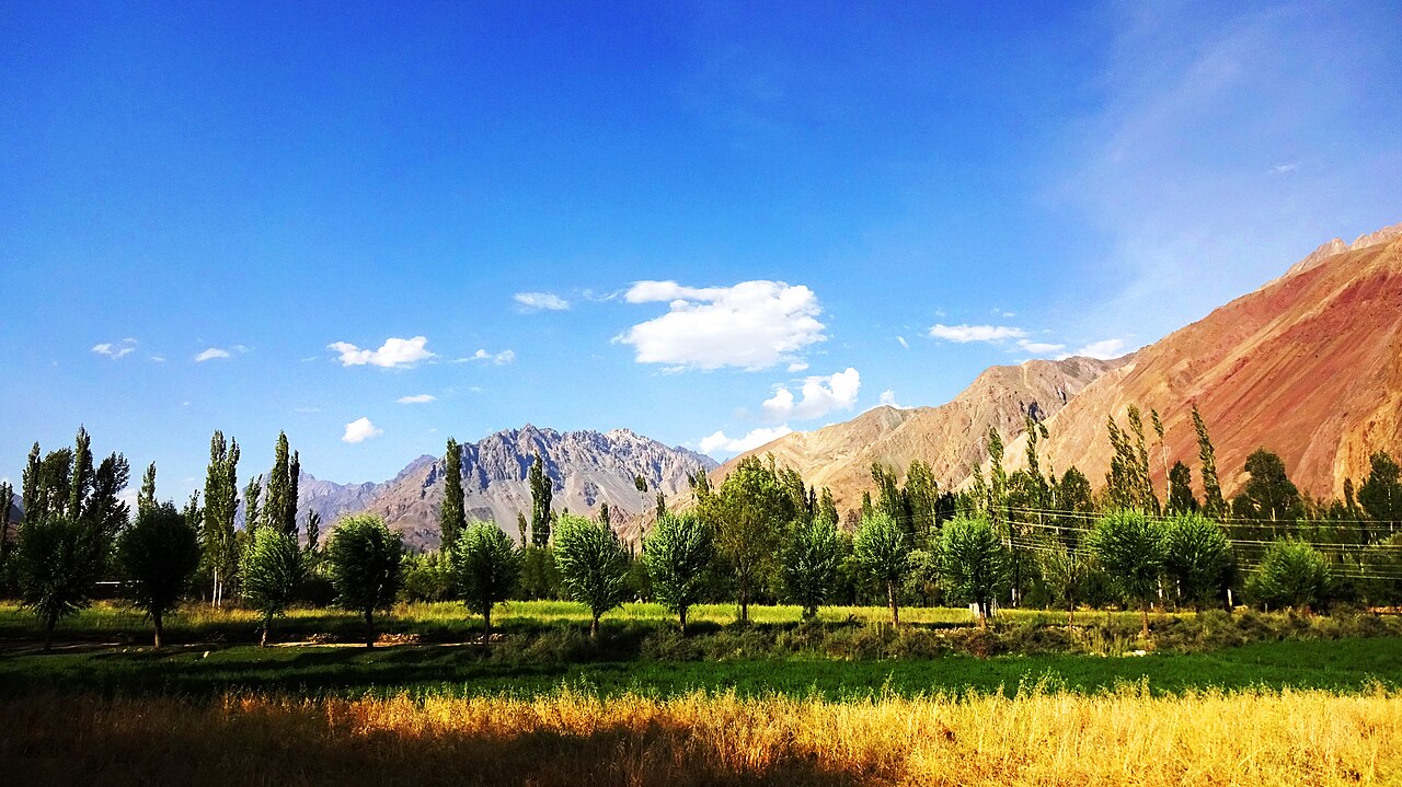
The Yasin Valley is a high mountain valley in the northwestern part of Gilgit–Baltistan, Pakistan, lying within the broad spine of the Hindu Kush. It forms part of a complex of interlinked valleys in the region, characterised by steep slopes, terraced fields and narrow river corridors. The valley's villages and seasonal pastures reflect a long history of mountain agriculture and local exchange across high passes.
Image gallery
9 Images


Location and access
Administratively the valley is associated with the Ghizer region (often referenced as the Gupis–Yasin area) of northern Pakistan. The most common approach for overland visitors is to travel along the main north–south artery and then branch off toward the valley: the route uses the Karakoram Highway before turning toward Gupis and following local roads northwest into Yasin. Travellers from Pakistan's capital typically proceed north from Islamabad and then continue by road into Gilgit–Baltistan, transferring to regional roads for the final approach into the valley. Roads and passes are affected by seasonal snow and weather, so timing and local advice are important.
Landscape, climate and land use
Yasin ranges from riverine terraces and irrigated fields at lower elevations to alpine meadows, scree slopes and higher glaciated ridges. The climate is a high‑mountain type with short, cool summers and long, cold winters; most agricultural and travel activity is concentrated in the warmer months. Local land use combines smallholder cultivation, fruit orchards (including widely planted stone fruits and apples across Gilgit–Baltistan), livestock grazing and limited woodland patches used for fuel and construction.
People, language and culture
The valley is home to small, dispersed settlements whose inhabitants maintain livelihoods based on farming, herding and seasonal labour. Cultural life in Yasin reflects traditions common to the highlands of northern Pakistan: community festivals, oral traditions and practices tied to the agricultural calendar. Local speech varieties and cultural traits show affinities with neighbouring valleys; regionally spoken languages include Burushaski, Shina and other Dardic and Pamir languages in different communities, reflecting the linguistic diversity of Gilgit–Baltistan.
History, passes and regional links
For centuries, Yasin and adjacent valleys have been connected by high mountain passes that facilitated trade, seasonal migration and social links across the greater Karakoram–Hindu Kush complex. Several passes separate Yasin from neighbouring valleys such as Ishkoman; these routes have been important for local commerce and for linking remote communities. The valley's strategic position in the highland network has influenced settlement patterns and historical contacts.
Tourism and practical information
Visitors are attracted by dramatic mountain scenery, trekking opportunities and the chance to observe traditional village life. Facilities are modest: larger villages provide basic guest accommodation and supplies, while services in remote hamlets are limited. Important practical points include checking seasonal road conditions, hiring local guides for unfamiliar tracks, and respecting community norms. Sustainable travel practices help support local livelihoods and protect fragile mountain ecosystems.
Conservation and development
Like many high‑mountain areas, Yasin faces pressures from climate variability, changing land use and the demands of development. Efforts to balance tourism, agriculture and conservation are part of regional planning, and community‑based approaches are increasingly promoted to maintain ecosystem services, protect water sources and preserve cultural landscapes.
- Access: approach via the Karakoram Highway Karakoram Highway and the turn toward Gupis before continuing into Yasin.
- Seasonality: plan travel in late spring to early autumn; snow can close mountain passes in winter.
- Local advice: consult regional travel resources and local administrations for current road and permit information.
Questions and answers
Q: What is Yasin Valley?
A: Yasin Valley is a high mountain valley in the Hindu Kush mountains in the northwest region of Gilgit in the Northern Areas of Pakistan.
Q: How is Yasin Valley separated from the Ishkoman Valley?
A: Yasin Valley is separated from the Ishkoman Valley by a high mountain pass.
Q: How can one reach Yasin Valley?
A: To reach Yasin Valley, one must take the Karakoram Highway north from Islamabad and then turn left to reach Gupis in Ghizar. After Gupis, one continues northwest to reach the Yasin Valley.
Q: What kind of natural beauty does Yasin Valley have?
A: Yasin Valley has a spectacular natural beauty.
Q: Where is Yasin Valley located?
A: Yasin Valley is located in the northwest region of Gilgit in the Northern Areas of Pakistan.
Q: What kind of mountains surround Yasin Valley?
A: Yasin Valley is surrounded by the Hindu Kush mountains.
Q: What is the route one has to take to reach Yasin Valley from Islamabad?
A: To reach Yasin Valley from Islamabad, one must take the Karakoram Highway north and then turn left towards Gupis in Ghizar. After Gupis, one continues northwest to reach the Yasin Valley.
Related articles
Author
AlegsaOnline.com Yasin Valley (Gilgit–Baltistan): geography, culture and travel overview Leandro Alegsa
URL: https://en.alegsaonline.com/art/109664