
Upper Normandy (Haute-Normandie): overview, geography, economy and history
A concise encyclopedia entry on Upper Normandy (Haute-Normandie), a former French region: geography, departments, economy, historical changes, culture and notable features.

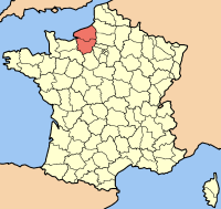
Upper Normandy, known in French as Haute-Normandie, was a formal administrative region of France in the north-west of the country. Centered on the city of Rouen, which served as the capital, the territory lay along the lower reaches of the Seine and included a mix of coastal, riverine and inland landscapes. At the start of the 21st century it had roughly 1.9 million inhabitants (circa 2007). In 2016 the region was administratively reunited with Lower Normandy to form the single region of Normandy, but the name Upper Normandy remains in common geographic and historical use.
Image gallery
5 Images


Geography and administrative divisions
Upper Normandy occupied a strategic location where the Seine meets the English Channel. The terrain combined fertile agricultural plains, chalk cliffs and important port facilities. Administratively it consisted of two departments: Seine-Maritime, which includes the ports and coastal towns, and Eure, which is more rural and agricultural. Major urban centres included Rouen, Le Havre and Évreux, each playing different roles in commerce, industry and culture.

History and development
The modern entity called Upper Normandy was created in the mid-20th century when the historic province of Normandy was divided for administrative purposes. From 1956 until 2016 the two-part arrangement — Upper and Lower Normandy — governed regional matters. During this period the area developed an industrial base while preserving agricultural traditions; in 2016 the two parts were merged back into a reunited Normandy region as part of a national territorial reform.
Economy and industries
Upper Normandy combined intensive agriculture with heavy industry. It was long notable as France’s leading producer of flax, a crop used for linen and other textiles. Industrial districts around the Seine supported petrochemical plants and related activities; the regional economy also included manufacturing and a growing pharmaceutical sector, components often grouped together under the umbrella term industries. The presence of large ports supported trade, shipbuilding, and logistics.
Culture, transport and notable facts
Culturally, Upper Normandy preserved many urban and rural landmarks: Gothic churches, maritime architecture and coastal scenery that attracted artists and tourists. Rouen’s cathedral and the cliffs at Étretat are prominent examples. Transport links — river navigation on the Seine, major roads and sea access at Le Havre — helped make the area an economic corridor between Paris and the English Channel. Though its administrative status changed, the term Upper Normandy continues to describe this distinctive portion of the Normandy region in geography, economy and heritage.
Quick reference
- Former administrative name: Haute-Normandie
- Reunited with: Lower Normandy to form Normandy
- Main departments: Seine-Maritime, Eure
- Notable sectors: agriculture (flax), petrochemical, manufacturing, pharmaceuticals
Related articles
Author
AlegsaOnline.com Upper Normandy (Haute-Normandie): overview, geography, economy and history Leandro Alegsa
URL: https://en.alegsaonline.com/art/103492