Tsushima Strait (Korea Strait): geography, history, and significance
A concise overview of the Tsushima Strait (also called the Korea Strait), its geography, channels, currents, historical role, economic importance, and naming distinctions between Japan and Korea.
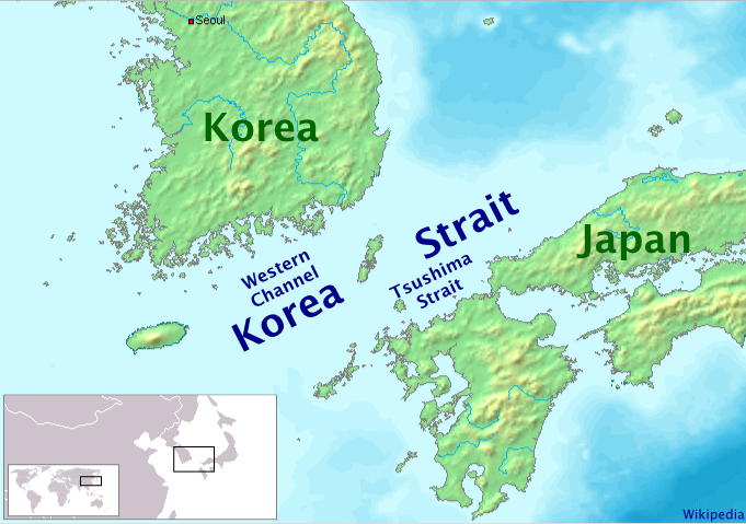
The Tsushima Strait, commonly referred to as the Korea Strait in some contexts, is the narrow seaway separating the southwestern tip of Japan from the southeastern coast of South Korea. It forms part of the link between the open East China Sea and the relatively enclosed Sea of Japan, within the broader marine region of the northwest Pacific Ocean. The name can be used broadly for the oceanic area between the two countries or more narrowly to describe the passage bounded by the Japanese island of Tsushima Island and the southern Japanese island of Kyushu.
Image gallery
3 Images

Geography and physical characteristics
The waterway consists of two principal channels divided by Tsushima Island: a western route adjacent to the Korean coast and an eastern route between Tsushima and Kyushu. These channels vary in width and depth but are generally recognized as a relatively shallow passage compared with open ocean basins. The strait helps regulate water exchange between the seas and is traversed by notable currents, including a warm branch of the Kuroshio system often called the Tsushima Current, which carries warmer, saline water into the Sea of Japan and influences local climate and marine productivity.
History and strategic role
For centuries the strait has been a vital highway for ships, fishermen, and cultural contact across the Korean Peninsula and the Japanese islands. Its strategic importance became prominent in modern times: control of the seaway affected trade, naval movements, and military operations in East Asia. Several historical naval engagements and patrols have taken place in and near the strait, underscoring its value as both a commercial corridor and a strategic chokepoint.
Economic and ecological importance
The Tsushima/Korea Strait supports commercial shipping lanes connecting major ports, regional fisheries that harvest species attracted by mixing waters, and marine ecosystems shaped by the inflow of warm currents. Fishing, ferry services, and international trade rely on its navigable routes. The mixing of different water masses creates productive feeding grounds, while the passage also serves as a migration corridor for marine species.
Naming, boundaries, and modern context
Terminology can differ by country and discipline: some sources favor the historic name "Korea Strait," others "Tsushima Strait." The word Korea Strait is used alternately with the local Japanese name for the channel. Today the area is governed by modern maritime boundaries, international shipping regulations, and cooperative management of fisheries and search-and-rescue operations. Navigation charts and maritime authorities on both sides maintain detailed information about depths, currents, and safe routes through this busy corridor.
Notable facts and distinctions
- The passage functions both as an international sea lane and as a local transport link between islands and peninsulas.
- Its currents contribute to the Sea of Japan's temperature and ecosystem dynamics.
- Names and cartographic labels may vary according to national usage and historical context; researchers and mariners therefore consult multiple sources when planning passage through the strait.
For navigational, historical, or environmental research, authoritative maritime guides and national hydrographic offices provide up-to-date charts and advisories for the Tsushima/Korea Strait region; general background materials are also available through regional oceanographic and historical references linked to broader studies of the East China Sea, the Sea of Japan, and the wider northwest Pacific Ocean.
Related articles
Author
AlegsaOnline.com Tsushima Strait (Korea Strait): geography, history, and significance Leandro Alegsa
URL: https://en.alegsaonline.com/art/101898
Sources
- books.google.com : The New York Times Guide to Essential Knowledge, 2nd ed., p. 609
- books.google.com : "Tsushima Kaikyō"
- state.gov : "Limits in the Seas, No. 121; Straight Baseline and Territorial Sea Claims: South Korea," p. 23
- books.google.com : Island Disputes and the Law of the Sea: An Examination of Sovereignty and Delimitation Disputes, p. 27
- books.google.com : Maritime Boundary Disputes, Settlement Processes, and the Law of the Sea, p. 53