South Korea
Template:Infobox State/Maintenance/TRANSCRIPTION
Template:Infobox State/Maintenance/NAME-German
The Republic of Korea (Korean: 대한민국, Hanja: 大韓民國, IPA [ˈtɛ̝ːɦa̠nminɡuk̚], revised romanization: Daehan Minguk, McCune-Reischauer: Taehan Min'guk), usually called South Korea, is located in East Asia and occupies the southern part of the Korean Peninsula. Its only land border is the 243 km border with its northern neighbor, North Korea. The two successor states to Chōsens were formed in 1948 during the emerging Cold War; the ensuing Korean War cemented the division of Korea. The North is socialist and autocratic, while a parliamentary democracy has been established over time in capitalist South Korea, which is diplomatically oriented toward the West. To the west, South Korea borders the Yellow Sea (in South Korea: West Sea), to the south the East China Sea, and to the east the Sea of Japan (in South Korea: East Sea).
With around 51.7 million inhabitants, South Korea is one of the 30 most populous countries in the world and, with over 500 inhabitants per square kilometre, one of the most densely populated states. About half of the population lives in the metropolitan area of the capital Seoul, a cosmopolitan city with the fourth largest economic output worldwide. Over two million people live in each of the cities of Busan, Incheon and Daegu.
"The Miracle on the Han River", as the period of rapid economic growth from 1962 onwards is called, quickly transformed South Korea from a poor agricultural country into a modern industrial state. It is also referred to as a tiger state. In the production of ships and electronic products such as semiconductors, microchips, flat screens and computers, South Korean industry has achieved a dominant position in the market. This has also increased the country's cultural importance, which is expressed in the Korean Wave, for example. The country is a member state of the United Nations, the G20, the OECD, APEC and ASEAN+3.
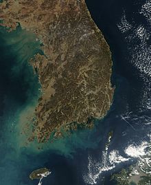
Satellite image of South Korea
State name
The official German state name is Republic of Korea; colloquially, however, one usually speaks of South Korea. In Korean, the country is officially called Daehan Minguk (대한민국, 大韓民國; Eng. "Republic of Greater Korea"). It is commonly called Hanguk (한국, 韓國, "Korea state") or Namhan (남한, 南韓, "South Korea") in its short form in South Korea, in distinction from Bukhan (북한, 北韓, "North Korea"). Since in North Korea "Korea" is not referred to as Han (한, 韓) but as Chosŏn (조선, 朝鮮), "South Korea" there is appropriately called Nam-Chosŏn (남조선, 南朝鮮).
The word Han (한, 韓) traces its origin to the historical empire Samhan (삼한, 三韓; "Three Koreas"), which was formed from the empires Mahan, Jinhan and Byeonhan and existed in the period from the first to the fourth century AD. This name was taken up again in the name of the empire Daehan Jeguk (Empire of Greater Korea) founded in 1897.
The name in Western languages has its origin in Cauly, as Marco Polo called the peninsula during his travels in the late 13th century. This is probably based on the Chinese pronunciation of the Korean kingdom Goryeo (Chinese Gāolì). In European records, both spellings Corea and Korea appeared until the 20th century. In English and German, the spelling with K eventually prevailed, in Romance languages the spelling with C.
Geography
South Korea's land area is 100,284 square kilometers. Of this, 290 square kilometers are water areas; there are no major natural lakes.
South Korea comprises the southern part of the Korean Peninsula and offshore islands. Near the west coast and in the southeast is flat land, but almost everywhere interspersed with hills, which constitutes at most one-third of the national territory, but is home to the great majority of the inhabitants. The great rest of the country is mountainous; except on a narrow strip on the east coast and in small valley bottoms there are no lowlands. Both the mountains and the hills of the plains are mostly wooded; though they seldom reach great heights, they often have a steep relief.
Mountains and mountain ranges
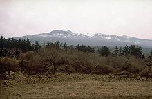
About 70% of South Korea is mountainous. The highest mountain is the volcano Hallasan with 1950 meters on Jeju Island, on the South Korean mainland are the highest Jirisan in the south with 1915 meters and the Seoraksan in the northeast with 1708 meters. South Korea is crisscrossed by five major mountains, the largest being the Taebaek Mountains. It begins in southeastern North Korea and then runs along almost the entire east coast of South Korea. The second largest mountain range, called Sobaek, branches off from Taebaek in a southwesterly direction; it runs through the center of the country. Smaller are the Gwangju, Charyeong and Noryang mountains. The main watershed running from North Korea across the Seoraksan to the Jirisan is called the Baekdudaegan (백두대간; 白頭大幹).
Rivers
Four major rivers run through South Korea. The longest of them is called Nakdonggang and has a length of 525 kilometers. It originates from the confluence of two headwaters in the Taebaek Mountains near the city of Taebaek and flows from there, unlike most rivers in the country, to the south and flows into the East Sea near Busan. The second longest river, at 497.5 kilometers, is the Hangang, whose northern branch rises in North Korea. Its southern branch also rises at Mount Taebaek. Both Han rivers join about 35 kilometres before Seoul, before they flow united through the middle of the capital and shortly afterwards flow into the Yellow Sea as a border river to North Korea. Other important rivers are the Geumgang (401 kilometers) and the Seomjingang (212 kilometers).
Coast and islands
South Korea abuts the sea on three sides:
- In the east to the East Sea, internationally also called "Sea of Japan" (see also name dispute about the Sea of Japan),
- in the south to the Korea Strait,
- in the west to the Yellow Sea. The coastline is a total of 2413 kilometers long.
The coasts in the west and south have as Ria many bays and peninsulas, which are offshore about 4400 medium-sized and smaller islands. Of these, less than 500 are inhabited. The second largest mudflat in the world, called Saemangeum, is also located on the west coast. The east coast, which is poor in bays and steep in many places, has only a few and very small islands and rocks offshore.
The largest island by far is called Jejudo, which is located about 150 kilometers south of the southwest coast of the mainland, is 1845.6 square kilometers in size and forms the province of Jeju-do together with several small islands.
flora and fauna
About two thirds of the country is forested. The original mixed forests with oaks, maples, beeches, elms, poplars, spruces and aspens have given way to secondary forest in many places, as a great deal of forest has fallen victim to the need for firewood and slash-and-burn agriculture. At higher altitudes coniferous forest with spruces and larches follows. The flora of South Korea is considerably richer in species than that of Central Europe. The easily visible higher plants alone are represented with about 3400 species and subspecies in 880 genera. Thus Korea's plant palette ranges from alpine mountain pines and rhododendrons above the tree line in the northern mountains to subtropical bamboo, laurel and camellias on the warm southern coast and on Jejudo.
Large mammals such as tigers, leopards and bears were common throughout the Korean Peninsula; however, deforestation and poaching have virtually eliminated them from South Korea. Lynx and Bengal cats live in the forests, and there are seals on the coasts. Notable bird species include the mandarin duck, white-bellied black woodpecker, Manchurian crane and neck-ringed scops owl. About 3.9% of South Korea's land area is protected.
Climate
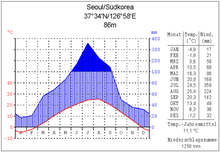
South Korea is located in the temperate climate zone, in which one distinguishes four different seasons. Exceptions are some subtropical valleys on the south coast of Jejudo and some high altitude regions above 1700 meters.
Spring usually starts between the end of March and the beginning of April and is mild and quite sunny. Winds then often carry fine yellow desert dust from the Gobi Desert to South Korea. In summer, southerly winds bring hot, humid air from the Philippines. The summer monsoon season, called jangma (장마) in South Korea, usually begins in late June or early July and lasts into September. Most of the annual precipitation falls during this period. Rain alternates with clear days. This is followed by a very hot midsummer, which is difficult to bear, especially because of the high humidity. The daily maximum temperature then often exceeds 30 °C, accompanied by a humidity of 80 to 95 %.
Autumn sets in mid-September, when the winds start blowing from the northwest again. The dry continental air provides plenty of sunshine, while the temperature slowly begins to drop. Winter in South Korea is very cold and dry. The winds from Siberia rarely bring snow. From January onwards, a special climate constellation provides a peculiar temperature pattern, with three cold days alternating with four somewhat milder ones.
Climate data
| Month | Jan | Feb | Mar | Apr | May | Jun | Jul | Aug | Sep | Oct | Nov | Dec | |||
| Season | Winter | Spring | Summer | Fall | Winter | ||||||||||
| Weather distinguishing features | cold | mild | warm | moderately | cold | ||||||||||
| dry | damp | dry | |||||||||||||
| Snow | Hwangsa | clear | Rain | much rain/typhoon | clear | Snow | |||||||||
| Year | Spring | Summer | Fall | Winter | Jan | Feb | Mar | Apr | May | Jun | Jul | Aug | Sep | Oct | Nov | Dec | |
| T-mean (°C) | 11,5 | 10,4 | 22,7 | 13,4 | −0,5 | −2,1 | −0,3 | 4,6 | 10,9 | 15,9 | 20,0 | 23,6 | 24,4 | 19,6 | 13,7 | 6,9 | 0,8 |
| T-Min (°C) | 6,5 | 4,8 | 18,5 | 8,2 | −5,5 | −7,0 | −5,2 | −0,8 | 5,0 | 10,2 | 15,3 | 19,9 | 20,4 | 14,9 | 8,0 | 1,8 | −4,2 |
| T-Max (°C) | 16,5 | 16,1 | 26,9 | 18,7 | 4,4 | 2,8 | 4,6 | 9,9 | 16,8 | 21,7 | 24,8 | 27,4 | 28,5 | 24,4 | 19,5 | 12,1 | 5,8 |
| T-distance (°C) | 10,0 | 11,3 | 8,4 | 10,4 | 9,8 | 9,8 | 9,7 | 10,6 | 11,7 | 11,5 | 9,5 | 7,5 | 8,1 | 9,5 | 11,4 | 10,4 | 9,9 |
| Frost Days | 114,2 | 26,0 | 0,7 | 17,1 | 70,5 | 25,5 | 21,9 | 18,0 | 6,7 | 1,3 | 0,4 | 0,2 | 0,2 | 0,4 | 3,6 | 13,1 | 23,0 |
| Rainy days | 119,6 | 28,1 | 39,8 | 26,0 | 25,6 | 8,8 | 8,6 | 9,1 | 9,7 | 9,3 | 11,6 | 15,2 | 13,1 | 10,0 | 7,3 | 8,7 | 8,2 |
| Precipitation (mm) | 1404 | 287 | 723 | 283 | 111 | 37 | 44 | 66 | 110 | 111 | 187 | 289 | 247 | 159 | 67 | 57 | 30 |
| Air pressure (hPa - 1000) | 11,9 | 9,0 | 22,2 | 12,1 | 4,2 | 3,7 | 4,2 | 5,7 | 8,8 | 12,5 | 17,9 | 24,1 | 24,5 | 17,7 | 11,3 | 7,2 | 4,6 |
| Cloudiness (%) | 52,9 | 51,8 | 66,9 | 49,9 | 43,2 | 42,2 | 47,5 | 49,7 | 52,1 | 53,6 | 66,2 | 71,8 | 62,7 | 59,4 | 45,2 | 45,0 | 40,0 |
Mean values for the years 1961-1990. Seasons denote a full quarter of each year (spring: March to May, summer: June to August, autumn: September to November, winter: December to February)
Note: The source of this data is no longer available, but statistical climate data from the Korean government from 2001 to 2017 is.
The average data of individual regions partly deviate significantly from those mentioned. In the northern and central regions, higher temperature differences over the year must be expected than in the southern coastal areas. On the east coast it is usually somewhat warmer than on the west coast, as the Taebaek Mountains prevent cold winds from Siberia from blowing in.
Natural phenomena
Unlike neighbouring Japan, South Korea is hardly affected by natural disasters. On average, only 20 earthquakes occur in South Korea each year. Of these, an average of 9.2 earthquakes per year are above the value of 3.0 on the Richter scale (corresponding to the "perception threshold" of an earthquake). In the long-term trend, however, the number of earthquakes has increased again since 1992. In 2006, a total of 50 earthquakes occurred, in 2007 a total of 42 and in 2008 a total of 46. In Japan, on the other hand, around 1200 earthquakes with intensities greater than 3.0 on the Richter scale are recorded each year. However, there are no active volcanoes in South Korea.
Typhoons can occur especially between late July and early September, but they usually lose their power before they reach South Korea. From March to May, the air is sometimes filled with fine yellow desert sand (kor. 황사 hwangsa), which blows in from China or Mongolia together with pollutants and settles over the country like a blanket of fog.
Environment
See also: Transnational pollution in East Asia
South Korea's rapid economic growth has led to numerous side effects on the environment. Emissions from industry and traffic create high air pollution and cause acid rain. Per capita, South Korea emits 9.5 tons of carbon dioxide annually (2002 estimate). South Korea had the ninth-highest CO2 emissions in 2015. South Korea is the world's second largest consumer of CFCs despite its relatively small population. Another major problem is water pollution from residential and industrial wastewater, as well as rapidly growing piles of garbage caused in part by wasteful packaging of consumer goods. The problem of transboundary pollution is being attempted to be solved by the South Korean Ministry of the Environment together with the relevant agencies of Japan and the People's Republic of China.
During the Asian crisis, it became apparent that the South Korean economy is very dependent on energy imports. South Korea has therefore set itself the goal of promoting renewable energies for the 21st century. The government program "Low Carbon, Green Growth" has been in place since 2008. It contains long-term strategies for the promotion of green environmental technologies. In January 2009, in the wake of the global economic crisis, a further green economic stimulus package worth 50 trillion won was launched. This was followed in July 2009 by a five-year green growth plan worth 107 trillion won, which also aims to promote sustainable economic activity. Overall, the programs are aimed at expanding renewable energies, revitalizing polluted rivers, creating an environmentally friendly transportation infrastructure and energy-saving measures. In addition, 1.8 million new jobs are to be created in the environmental sector.
Management structure
→ Main article: Administrative division of South Korea
South Korea is politically divided into a Special City at the highest sublevel:
Seoul,
into a special autonomous city:
Sejong,
into six independent major cities:
Busan, Daegu, Daejeon, Gwangju, Incheon and Ulsan
in eight provinces:
Chungcheongbuk-do, Chungcheongnam-do, Gangwon-do, Gyeonggi-do, Gyeongsangbuk-do, Gyeongsangnam-do, Jeollabuk-do and Jeollanam-do
as well as to a special autonomous province:
Jeju-do.
Cities
See also: List of cities in South Korea
The largest city, with 10,103,233 inhabitants, is the capital Seoul in the northwest. Together with the surrounding cities, it forms the Sudogwon metropolitan region, with about 25 million inhabitants the second largest metropolitan area in the world after Tokyo. In the extreme southeast of the peninsula lies South Korea's second largest city Busan (3,519,401 inhabitants); it has one of the world's busiest ports. It is followed by the port city of Incheon (2,902,608 inhabitants) on the west coast just outside Seoul, and Daegu in the southeastern interior with 2,493,264 inhabitants. The fifth largest city is the centrally located Daejeon with 1,531,809 inhabitants, and the sixth largest is Gwangju with 1,475,884 inhabitants in the southwest. Unlike the cities mentioned above, Suwon (1,174,228 inhabitants), Goyang (1,006,154 inhabitants) and Seongnam (974,608 inhabitants) are not politically equivalent to a province, but belong to the province of Gyeonggi-do. Like Incheon, they are so close to Seoul that they are now connected to its subway network. The eighth largest city is Ulsan, located on the southern part of the east coast, with 1,166,377 inhabitants.
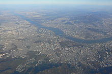
Seoul from the bird's eye view
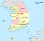
Political map of South Korea
.jpg)
South Korea has four seasons
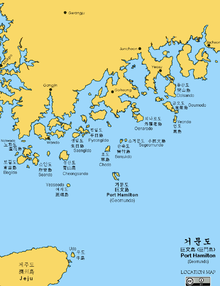
Detail of the south coast
Climate diagram Seoul
Mount Hallasan in Jeju-do
Questions and Answers
Q: Where is South Korea located?
A: South Korea is located in the southern part of the Korean peninsula, in the northeast region of Asia.
Q: What is the capital city of South Korea?
A: The capital city of South Korea is Seoul.
Q: What is the official name of South Korea?
A: The official name of South Korea is the Republic of Korea in English, 대한민국 (Daehan Minguk) in Korean writing (Hangeul), and 大韓民國 in Chinese characters (Hanja).
Q: Where do half of the country's people live?
A: Half of the country's people live in its capital city, Seoul, or near the city in the metropolitan area.
Q: Is Seoul metropolitan area one of the most populous metropolitan areas in the world?
A: Yes, Seoul metropolitan area is one of the most populous metropolitan areas in the world.
Q: Is South Korea considered a significant cultural power?
A: Yes, South Korea has become a significant cultural power in recent years, largely due to bands like BTS, Korean drama, as well as its economic miracle.
Q: What is the economic situation of South Korea?
A: South Korea's economic situation is considered a miracle, having experienced rapid industrialization, economic growth, and development over the years.
Search within the encyclopedia