
Taiwan Strait (Formosa Strait) — geography, history, and significance
The Taiwan Strait is the sea passage between mainland China and Taiwan. This article explains its geography, oceanography, history, strategic role, economic importance and environmental issues.
The Taiwan Strait, also historically called the Formosa Strait, is the body of water that separates the island of Taiwan from mainland China. It lies within the broader region of the South China Sea and opens toward the East China Sea on its northeastern side. The strait is relatively narrow for an international waterway: its commonly cited width is about 180 km, with the narrowest point roughly 131 km across. The name "Taiwan Straits" is a frequent misnomer; the correct English is "Taiwan Strait."
Image gallery
10 Images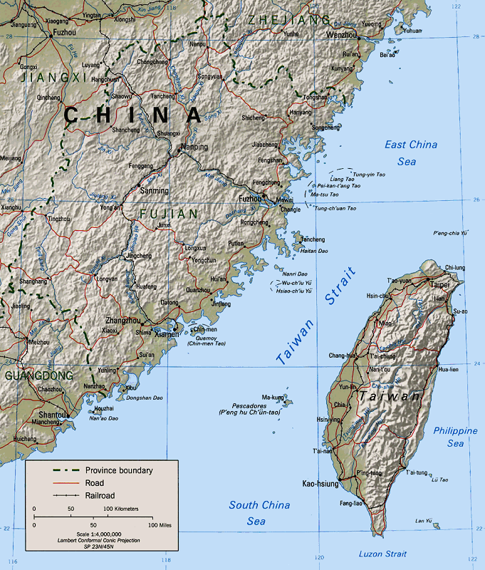




Geography and physical characteristics
The channel is shallow compared with many oceanic passages, with a continental shelf that influences currents, waves and sediment transport. Tidal currents, monsoon winds and seasonal temperature differences shape the hydrography, producing a dynamic marine environment. The strait forms an important link between adjacent seas and affects local climate patterns on both sides. Its bathymetry and current patterns have practical consequences for navigation, fishing and coastal communities.
History and strategic significance
Since the mid-20th century the Taiwan Strait has been a focal point of cross-strait relations. After the Chinese Civil War in 1949, forces of the Republic of China retreated to Taiwan and the waterway became a de facto maritime frontier. The area witnessed major confrontations during the 1950s, and it remains central to military planning and exercises by both the People's Republic of China and Taiwan. Because of its proximity to densely populated coastlines and major ports, any escalation in the strait can have wide regional consequences.
Economic and maritime importance
The Taiwan Strait sees heavy shipping traffic, including commercial vessels moving between East Asian ports and broader international routes. Coastal fisheries are economically important for communities on both sides. Proposals and occasional discussions about fixed links — such as bridges or tunnels — have appeared in public debate, but the combination of political, environmental and engineering challenges has so far prevented realization of such projects. The strait's waters are governed by international maritime law frameworks that affect passage rights and resource claims.
Environment and ecology
The strait supports diverse marine life and productive fisheries, but it is also subject to pollution pressures from coastal development, shipping and land-based runoff. Seasonal upwelling and mixing influence nutrient availability and fish distribution. Conservationists and local authorities on both sides occasionally coordinate on research or incident response, although political tensions can complicate sustained cooperative efforts.
Contemporary issues and notable facts
Today the Taiwan Strait remains one of East Asia's most sensitive waterways. It is frequently mentioned in discussions of regional security, freedom of navigation, and cross-strait diplomacy. Civilian shipping generally continues under peacetime norms, but naval activity, air patrols and periodic exercises attract international attention. Historical names, legal questions and environmental concerns all contribute to the strait's complexity as both a practical maritime corridor and a symbol of broader political issues.
Further reading and resources
- General map and overview of the Taiwan Strait
- Mainland China coastal information
- Taiwan government maritime resources
- South China Sea regional context
- East China Sea connections
- People's Republic of China policy materials
- Republic of China (Taiwan) policy materials
- Background on the Chinese Civil War
- Timeline of key post-1949 events
- Historical context about the Kuomintang
- Biographical and historical sources on Chiang Kai-shek
Related articles
Author
AlegsaOnline.com Taiwan Strait (Formosa Strait) — geography, history, and significance Leandro Alegsa
URL: https://en.alegsaonline.com/art/95952